STP 07-19-2017: High Moisture Supplies Storms with Lots of Rainfall

Issue Date: Wednesday, July 19, 2017
Issue Time: 10:25AM MDT

Summary:

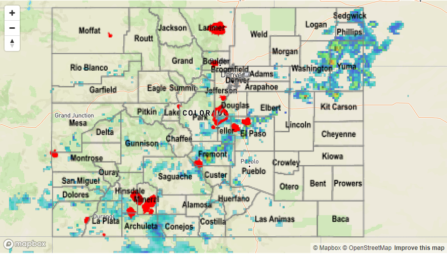
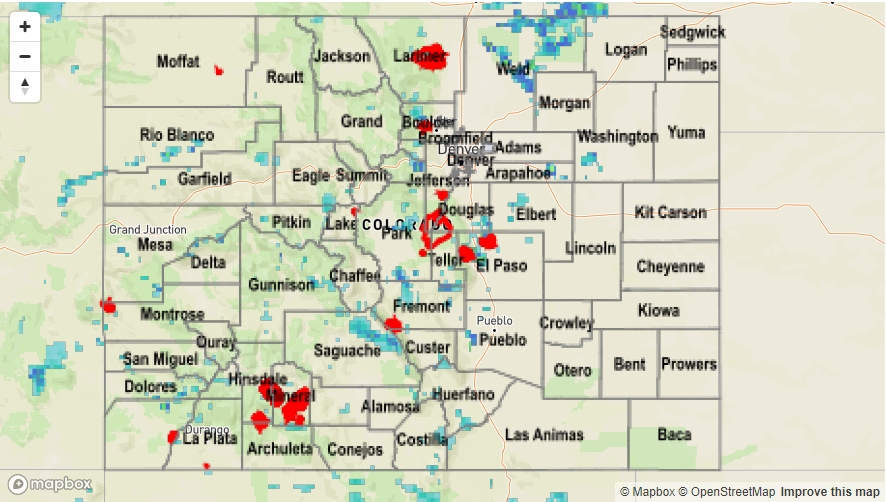
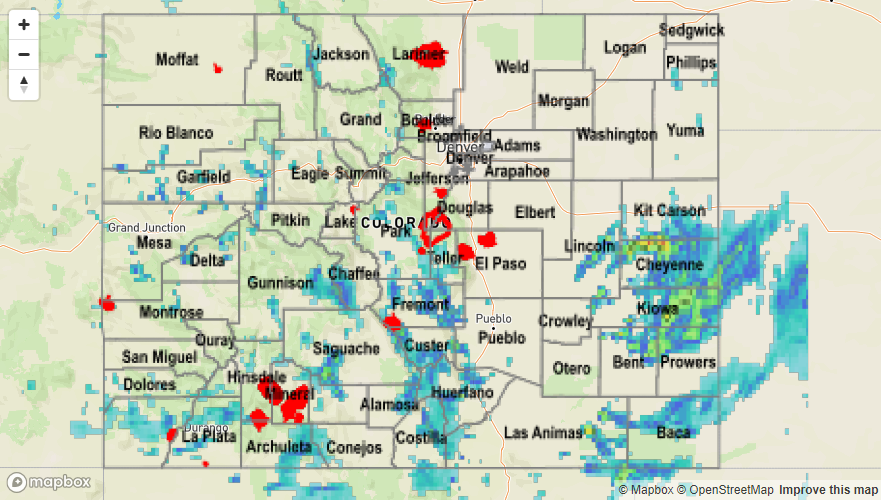
Precipitable Water (PW) ended up increasing dramatically over the entire eastern portion of the state yesterday afternoon. PW values were at least 1 inch and over 1.5 inches in the Northeast Plains. Convection occurred over the central and southern mountains, with 1 hour rain rates just over 0.5 inches with Silverton reporting 0.62 inches in one hour. Teller County reported 0.6 inches in 30 minutes. The highest total rainfall recorded value was over Clear Creek County with 1.1 inches in 3 hours. Radar estimates 3 hour totals of 2 inches. Small stream flooding occurred over Cotopaxi and Texas Creek in west Fremont County at 6:50 PM.

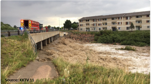
Both Colorado Springs and Pueblo had areal flooding advisories and flash flooding. Over Colorado Springs, rainfall totals of 2.37 inches were reported. There was even a report of 2.94 inches in just over 30 minutes in this same area southwest of Colorado Springs. This was located in the storm core, but there isn’t a sure way to verify this amount. Nonetheless, it shows the intensity of the rainfall. Radar estimates were 1.5 inches per hour with 3-hour totals of 2.5 inches. Total rainfall over Pueblo was estimated at 1.5 inches. Over Colorado Springs, total rainfall was estimated at 2.5 with the highest recorded precipitation value of 1.18 inches at a CoCoRaHS station near the airport. Gusts up to 41 mph were also recorded. A photo from Sand Creek in Colorado Springs from KKTV 11 News is below.

Lastly, severe thunderstorms fired over the Northeast Plains along a surface boundary. High PW in this area and dew points up to 65F, lead to heavy local rainfall, flooding, strong winds and 1 inch hail. A flash flood warning was issued for west central Yuma County at 6:35 PM where a severe thunderstorm produced 3 to 5 inches of rain. Radar estimated storm totals show up to 4+ inches with 1-hour rain rates of 2.5 inches and 2-hour rain rates of 4 inches. CoCoRaHS in the area have rainfall total up to 1.54 inches, but most of the storms occurred in ungauged territories. There were no official flood reports for these storms.

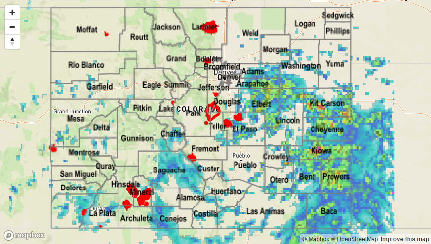
To see how much precipitation fell over the last 24 hours, see the Storm Total Precipitation Map below.

Storm Total Precip Legend

STP 07-18-2017: Very Isolated Heavy Rainfall

Issue Date: Tuesday, July 18, 2017
Issue Time: 10:00AM MDT

Summary:

The ridge over northern Colorado limited the southerly surface winds and thus, moisture from the south. Weak upslope flow set up with a dry air mass yesterday afternoon. The strongest storms were confined to the mountains and southern Urban Corridor against the mountains. The southern portion of the high country favored higher moisture. Most storms that formed had gusty winds and small hail. The highest wind gust recorded was 30 mph at the Air Force Academy. Storm totals were up to 1 inch from the radar estimates over the mountains. CoCoRaHS highest total was in San Juan County with 0.5 inches.

Storms quickly weakened as they moved off the mountains, but not before dumping heavy rain over Colorado Springs. Most of the Urban Corridor reported totals were over an inch with the highest report being 1.38 inches at Peterson AFB. Radar estimates of 1-hour precipitation were just over one inch with totals as high as 1.5 inches. Just north of Colorado Spring, there was an Areal Flood Advisory for a storm that produced 0.87 inches in 20 minutes near Palmer Park. A USGS gage at Foothills Elementary recorded 0.7 inches in 1 hour. Gusty winds and small hail were also associated with the thunderstorms that formed yesterday. There were no storm reports other than this heavy rain as of this morning.

To see how much precipitation fell over the state in the last 24-hours, see the Storm Total Precipitation Map below.

Storm Total Precip Legend

STP 07-17-2017: Flash Flooding with Heavy Rainfall

Issue Date: Monday, July 17, 2017
Issue Time: 9:55 AM MDT

Summary

Storms began to fire over the higher terrain again yesterday afternoon. A weak surface low formed over the SE Colorado, which helped pull moisture into the southern portion of the state and helped organize low-level convergence. Although the coverage of storms was less impressive than Saturday, there was still local flooding with storms that were able to fire up. A flash flood warning and flash flood advisory were issued for SW Chaffee County along the Sawatch Range. Radar indicated 1.6 inches of rain over saturated soils. There was also flooding reported along Hayden Creek on the west side of the Hayden Pass burn scar. The last flash flood warning was issued for the Junkins burn scar, although no flooding was reported as of Monday morning. Heavy rainfall of 0.97 inches was reported near Beulah, CO. Totals in the mountains ranged from 1 to 2.2 inches with 1-hr rates just over 1 inch. The largest observed value was at a SNOTEL station near Monarch, which recorded 1 inch of rainfall.

Storms also fired up over the Eastern Plains along the KS border. There were several flood advisories with 1-hr totals of 2.5 inches estimated by radar and 3-hr totals of 3 inches estimated by radar. Local CoCoRaHS showed up to 1 inch of rain over bucketed areas. These storms had heavy rain as well as 0.75 inch hail and gusty winds. Lamar airport recorded gusts of 38 mph. The USGS gage measuring the Arkansas River at Lamar is running at the Action stage from yesterday’s rainfall. CoCoRaHS stations recorded just under 1 inch of rainfall, but radar rainfall estimates over rural Prowers County show 2 inches of rain with other thunderstorms contributing in the Southeast Plains. The Arkansas River level is expected to drop under action level as this area of the state will remain dry today.

For rainfall estimates for the last 24-hours, please see the State Precipitation Map below.


Storm Total Precip Legend

STP 07-16-2017: Heavy Rainfall Resulted in Flash Flooding

Issue Date: Sunday, July 16th, 2017
Issue Time: 10:10 AM MDT

Summary:

Numerous thunderstorms produced heavy rainfall yesterday as high values of atmospheric moisture and a mid-level disturbance outdueled the upper-level ridge. Slow storm motions exacerbated the effect of heavy rain, allowing storms to dump rain over the same location for extended periods of time. Flash flooding was reported to the National Weather Service in multiple locations, including a mud flow on that closed Highway 285 just south of mile marker 148 in Chaffee County. Additionally, flood waters off of the Hayden Pass Burn Scar flooded a campground SW of Coaldale where residents and the campground were evacuated along County Road 6 (Fremont County). Further east over the plains, 2-3 feet of water covered the underpass at the intersection of Highway 287 and Highway 96 (street flooding was also observed in Eads).

Here is a quick listing of the heavy rain and flash flood reports submitted to the National Weather Service yesterday:

Heavy Rain: 3 miles SW of Air Force Academy (1.42 inches)
Heavy Rain 5 miles NE of Manitou Springs (1 inch)
Flash Flood: Eads (Kiowa County)
Flash Flood: 3 miles SSE of Buena Vista (Chaffee County)
Flash Flood: 4 miles SW of Coaldale (Fremont County)
Flash Flood: 1 mile SW of Coaldale (Fremont County)

Please see the STP map below for a look at precipitation totals from the last 24 hours.

Storm Total Precip Legend