STP 07-27-2017: Efficient Thunderstorms Drop Impressive Rainfall

Issue Date: Thursday, July 27, 2017
Issue Time: 10:50AM MDT

Summary:

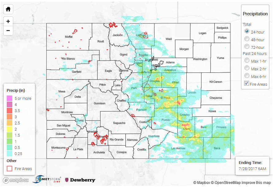
Yesterday was one of those July Colorado days where you could just feel the moisture when you walked out the door. Dew points were near 60F by noon across the Urban Corridor and Eastern Plains with the mid-levels saturated as well. The High pressure over Oklahoma allowed moisture to pour into the eastern plains. There was some drying throughout the day over the western portion of the state, which meant more isolated thunderstorms when compared to the previous couple days. Storms begin to fire off the high terrain a little later than normal with the upslope flow. Storm motion was more easterly, so the thunderstorms over the western portion of the state were confined to the mountains. In this area, local storm centers were estimated at 1.5 inches of rain. A CoCoRaHS station happened to be positioned over SW Gunnison County that captured that storm center at 3.11 inches. This gage should be read with a grain of salt as we were not able to confirm this 24-hour amount this morning.

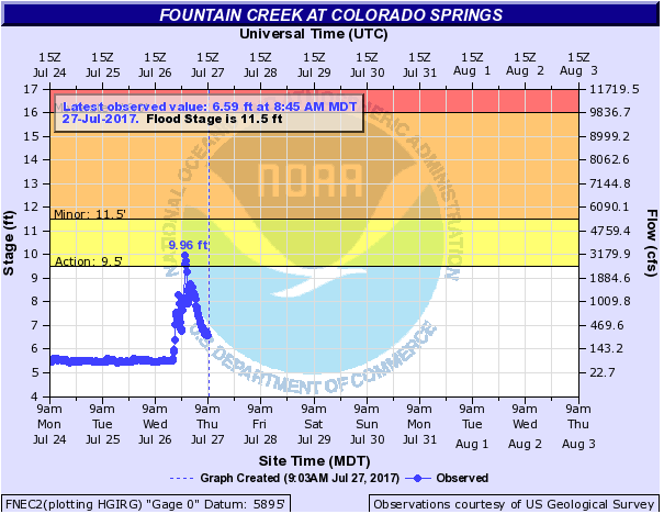
The storms that formed over the higher terrain of the Front Range and Southeast Mountains moved off the mountains in the late afternoon and evening. The rainfall amounts from these widespread storms were nothing less than impressive. With the high moisture, multiple rounds of storms were able to fire. The extensive precipitation gage network throughout the Urban Corridor gave us an idea pretty early in the afternoon about how efficient these storms were going to be. Over Douglas County near Russellville Gulch, 2.68 inches fell in 1-hour with 1.14” falling in 10 minute. Another storm was recorded dropping 2.48 inches in 45 minutes. While these were some of the highest rainfall amounts, other storms had well over 1 inch in 30-min. The list of the most impressive storm reports are below. CDOT reported rain washing mud and rocks onto most roads west of Denver, Golden and Boulder including US 285, CO 74, US 40, US 6,  CO 72 and CO 119. In Cripple Creek, CR 11 at US 67 was flooded. Ponding in yards and fields was also reported over the Franktown area. Radar estimates the 3-6 hour totals were just over 3.5 inches with CoCoRaHS stations recording 3.18 inches. A USGS gage recorded 3.05 inches at Fort Carson and 3.78 inches at Franktown. Fountain Creek was running high last night which can be seen at the gage in Colorado Springs reaching action level last evening.

Over the Eastern Plains, the high moisture was paired with larger instability and weak shear. This allowed storms in the SE corner to persist into the night. The 1-hour max precipitation rates were as high as 2 inches. The 3-6 hour totals were up to 4 inches with 24 hour total just over 4 inches in Otero County. Unfortunately, this area isn’t as well gaged, but a CoCoRaHS station recorded 3.5 inches of rain over Otero County for the 24-hour period.

Impressive reported rain totals:

10-min: 1.14” at Russellville Gulch near Franktown

10-min: 0.67 at UDFCD gage in Littleton

15-min: 0.96” at Cherry Hills ASOS

15-min: 0.79” at the Rosedale gage just west of Evergreen

15-min: 0.59” at 4mi Creek south of Deckers

15-min: 0.5” in Park County

18-min: 1.25” at Berthoud

20-min: 0.75” in Falcon near Colorado Springs

30-min: 1.5” at Marston Lake in Littleton

30-min: 0.98” in For Collins; 3 other gages reported over 0.9” in 30-min

30-min: 0.94” Choke Cherry Reservoir near Genesee

30-min: 0.91” at the Rosedale gage just west of Evergreen

30-min: 0.88” at Cripple Creek in Teller County

30-min: 0.5” at Porphyry gage near Jamestown

1-hr: 2.68” at Russellville Gulch near Franktown

1-hr: 1.13” at Fort Carson

To see how much rain fell over your area the last 24-hours, check out our new Precipitation Map below.

STP 07-26-2017: Continuous Rain Causes Flooding Problems for Western Colorado

Issue Date: Wednesday, July 26, 2017
Issue Time: 10:05AM MDT

Summary:

Yesterday morning started with clouds over most of the state and lingering showers over the west, central portion of the state. Cloud cover helped both keep temperatures down as well as limited instability over the northern portion of the state. Higher moisture also began to pour into the eastern portion of the state throughout the day. Daytime heating helped burn off some cloud cover, and around noon, the next set of storms started firing over the higher terrain starting in the south. Over the Western portion of the state, estimated 1-hour rain rates were under an inch. However, ongoing showers and thunderstorms throughout the day made a problematic situation for 3- and 24-hour totals on already saturated soils. Several Areal Flood Advisories were issued. Storm total estimates were as high as 2 inches in the mountains with the highest reported 1-hour rainfall of 1.82 inches in Saguache County at a CoCoRaHS station. In Montrose, 0.5 inches of rain fall in 25 minutes. Another location in Montrose reported 0.85 inches in 30 minutes. Trimble, CO reported 1.1 inches in the 24-hour period. Water was flowing across Highway 141 at mile marker 3 north of Dove Creek in Dolores County. All creeks north of Dove Creek were reported to be running full and spilling into the washes west of Dove Creek that cross Highway 491.

In the Front Range, cloud cover helped limit instability along the Urban Corridor. Storms over the higher terrain had storm totals up to 1.6 inches, but most quickly dissipated or weakened as they moved into the plains except over the Palmer Divide. An isolated storm managed to hold together out over the Southeastern Plains. The winds were strong enough to blow over several trees near Lamar at 4:30PM. Storm totals were as high as 3 inches with 1-hour rain rates up to 1.5 inches. Lastly, heavy rain producing thunderstorms were able to initiate over the NE corner of the state in the higher instability during the late afternoon and evening. Storm totals were 1.5 inches. There was no flooding reported with these storms.

To see how much precipitation fell in your neighborhood the last 24-hours, check out the Precipitation Map below:

Storm Total Precip Legend

STP 07-25-2017: Plume of Monsoon Moisture

Issue Date: Tuesday, July 25, 2017
Issue Time: 10:50AM MDT

Summary:

A surge of monsoon flow yesterday brought extremely high amounts of moisture into the state. Precipitable Water was at near record levels over the western portion of the state. This allowed numerous storms began firing over the higher terrain with the upslope flow around 11am. There was nearly continuous rain in the western portion of the state yesterday that continued through this morning. Isolated light showers are ongoing over the Southwest Slope and are moving northward/northwestward. These storms should begin to dissipate just as the next round begins to fire over the higher terrain. The continuous rainfall on saturated soils again today will exacerbate the danger of debris slides, mud flows and small stream flooding.

Yesterday, the 1-hour maximum rain rates were estimated by radar to be just over 0.5 inches over the western portion of the state. The more meaningful 24-hour accumulations, on top of already saturated soils, were estimated to be as high as 1.6 inches.  Heavy rainfall was reported in Durango with 0.75 inches falling in a short period of time. Over La Plata County, heavy rain of 0.94 inches was reported. The CoCoRaHS stations in La Plata County had widespread reports of 0.75-0.85 inches. A SNOTEL site in the San Juan Mountains reported 1.30 inches falling in the 24-hour period. Gusty winds accompanied these storms with a gust of 51 mph recorded at the Grand Junction Airport. Over the Front Range, an isolated cell in Teller County dropped an estimated 1.5 inches of rain. Large rivers continue to run under Action Stage in the higher terrain and Western Slope, but small streams are likely running high and should be monitored closely throughout the day with this next round of precipitation.

As of this morning, there were no flood reports for Monday. For rainfall estimates in your area, take a look at the Precipitation Map below.

Storm Total Precip Legend

STP 07-24-2017: Nearly Stationary Isolated Storms Produced Impressive Rainfall

Issue Date: Monday, July 24, 2017
Issue Time: 11AM MDT

Summary:

Though moisture decreased on Sunday, compared to the previous days, it is always good to keep in mind that our impressive mountains are capable of generating their own circulation. This allows for the production of storms that may seem surprising to a non-local. During clear summer mornings, quick heating allows the higher elevations to heat up higher than the nearby airmass (at the same altitude). This drives an upslope circulation that can create many intricacies that would be impossible without the mountains. The Palmer Ridge is a favored area for such processes. On Sunday, several nearly stationary cells developed on the northern side of the Palmer Ridge. Despite only lasting for an hour or two, the cells were able to deliver impressive rainfall amounts. One of the cells, over southern Douglas County, happened to fall directly on a rain gage maintained by the Urban Drainage and Flood Control District, which measured 1.02 inches of rain in 30 minutes. Another cell formed almost directly over the USGS gage on the South Platte River (near Cheesman Lake), where over 1 inch fell in less than 1 hour. What are the odds that each storm fell directly over a well maintained gage? Who knows, but we are grateful!

Farther west, stubborn moisture with monsoon origins, refused to leave Colorado. Although storm activity was less widespread than the past 48 hours, the strongest cells were still able to deliver heavy rainfall. For example, a CoCoRaHS observer in La Plata County reported 1 inch of rainfall in less than 1 hour.

Fortunately, flooding was not reported on Sunday. For rainfall estimates in your area, check out our Precipitation Map below.

Storm Total Precip Legend