SPM 08-12-2017: Plume of Moisture Aids Showers in Southern Colorado

Issue Date: Saturday, August 12, 2017
Issue Time: 09:40AM MDT

Summary

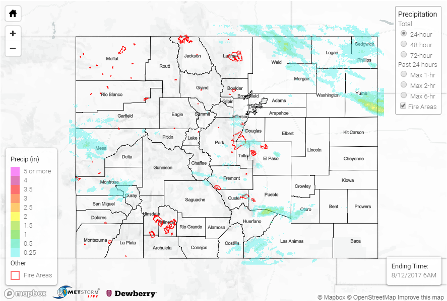
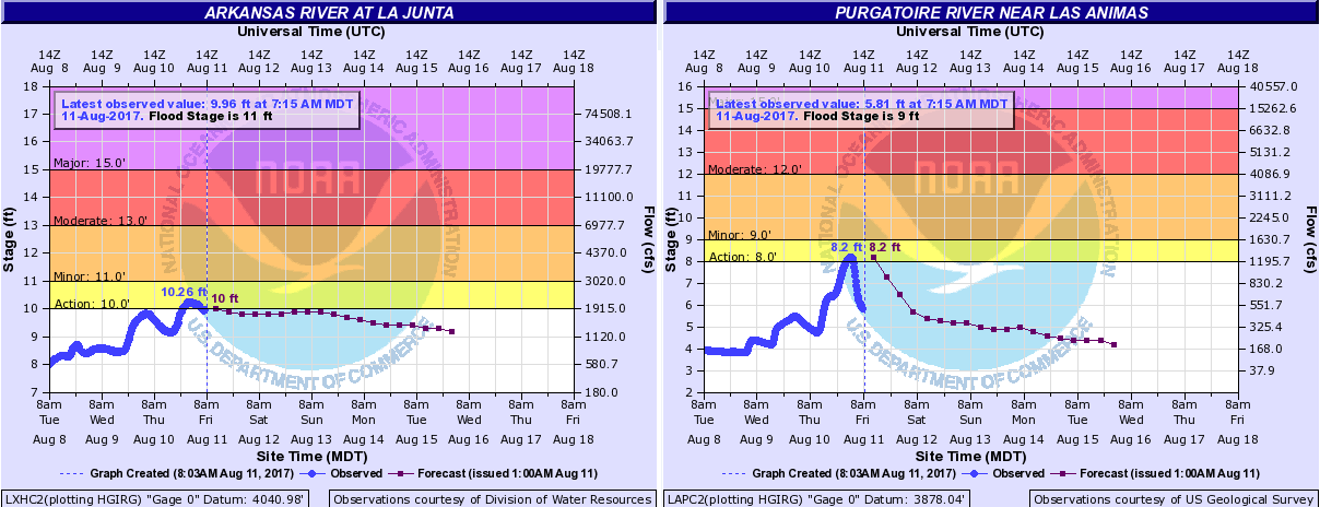
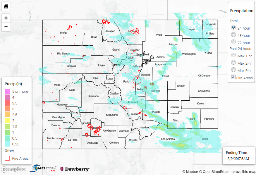
Monsoon moisture moved through the southern portion of the state yesterday. Showers began yesterday morning over the San Juan Mountains. The rain throughout the day accumulated to just over 1 inch. As this plume moved over E/NE, it encountered a fairly stable air. Cloud cover was not able to break up as much, which limited instability. However, this disturbance was strong enough to create widespread showers with some stronger embedded convection. One thunderstorm triggered Flash Flood Warning over the Junkins burn scar, but fortunately, no flooding was reported. As storms moved off the higher terrain they quickly dissipated in strength. The widespread showers were able to increase the flow enough at the USGS La Junta gage on the Arkansas River that it reached Action stage. Please stay tuned to the daily Flood Threat Bulletin for the latest information on the Arkansas River. Radar storm total estimates over this area were as high as 2.2 inches with a SNOTEL station recording 0.9 inches near the southern Southeast Mountains.

More storms were able to fire over the Cheyenne Ridge later in the evening that moved through the northeast corner of the state. While initially these storms had a Severe Thunderstorm Warning, they quickly began to weaken with the lack of instability. This was not before the storms quickly dropped 2.12 inches over Grover, CO in Weld County. Within this line of storms, radar estimates were highest in Yuma County where 2.9 inches fell in about one hour.

To see how much rain fell in your area, scroll down and take a look at the State Precipitation Map below.

SPM 08-11-2017: Severe Thunderstorms Produce Heavy Rain with Baseball Size Hail

Issue Date: Friday, August 11, 2017
Issue Time: 10:35AM MDT

Summary

Favorable thunderstorm dynamics and high moisture brought severe weather to the eastern plains yesterday. Storms formed over the mountains around midday and moved SE into high instability and shear. A few isolated supercells were able to form that dropped large hail, heavy precipitation and gusty winds. Eventually, these stormed merged and made a line of severe thunderstorms along the cold front that dropped south over the state in the evening and overnight hours. This storms ended just after midnight, but not before dropping impressive amounts of rain even though they were fast moving.

The highest precipitation amounts over the mountains were along the Northern Front Range where 0.95 inches fell at a CoCoRaHS gage. In the Fort Collins area, gusty winds and hail up to 0.88 inches in diameter were reported with the thunderstorms. Just north of Fort Collins, 1.43 inches of rain fell over a 30 minute period. Over Greeley, 2.38 inches of rain in 45 minutes was reported. Radar estimates in this area are as high as 2.2 inches. Further south, over the urban portion of El Paso County, a trained spotter recorded 1.1 inches in 20 minutes accompanied by 0.88 inch diameter hail. As the thunderstorms moved into the plains, and over more favorable severe thunderstorm dynamics, they dropped impressive rain and hail. Prowers and Bent County reported 2.75 inch diameter hail (baseball size)! Rainfall just over 3.5 inches was estimated by radar with a report of 2.7 inches in Walsh, Colorado.

Two gages along the Arkansas River basin have reached action stage yesterday. The first was the Purgatoire River near Las Animas and the second was the Arkansas River at La Junta. Rainfall over this basin is forecasted through the weekend, and with saturated soils, runoff will be high. There is a strong chance for riverine flooding at some point this weekend, though no major flooding is forecasted. We will continue monitoring the gages and any updates will be posted to our daily Flood Threat Bulletin and Twitter account @COFloodUpdates.

To see how much rain fell in your neighborhood, take a peek at the State Precipitation Map below.

STP 08-10-2017: More Heavy Rainfall Across Southeast Colorado

Issue Date: Thursday, August 10, 2017
Issue Time: 11AM MDT

Summary:

Though rainfall coverage was lower on Wednesday compared to previous days, this did not stop Mother Nature from delivering more heavy rainfall across parts of our state. Several rounds of shower and storm activity developed along the Front Range and then trekked south and eastward during the afternoon and evening hours. The most impactful storm of the day was probably over Teller County, where over 2 inches of rainfall likely fell in a 60-90 minute period. County Road 11 was flooded with 6 inches of water northwest of Cripple Creek. Some impressive streamflow spikes were measured from this storm. Fourmile Creek went from 100 c.f.s. to over 1,000 c.f.s. in less than 90 minutes (see below). Turkey Creek also experienced a brief spike, though flooding was not an issue.

Additional heavy rainfall occurred farther south and east as storms moved off the Palmer Ridge in the later afternoon and evening hours. At least two different storms moved across the cluster of USGS rain gages in Las Animas County, which measured two different pulses of about 1 inch per hour of rainfall. A few of the stronger cells became severe, prompting severe thunderstorm warnings for large hail and gusty winds.

Meanwhile, out west, storm coverage was isolated to scattered in nature. Rainfall amounts up to 0.5 inches were recorded, along with a few reports of gusty winds.

For rainfall estimates in your area, check out our State Precipitation Map below.

SPM 08-09-2017: PM Rain Strikes the Southeast Plains Again

Issue Date: Wednesday, August 9, 2017
Issue Time: 09:40AM MDT

Summary

Unlike Monday, clouds yesterday were able to break up and allow instability to build. This allowed for our more normal diurnal heating pattern to set up. Storms began to fire over the higher terrain in the early afternoon and moved off into a higher instability environment over the Southeast Plains. Paired with some shear over this same area, a Severe Thunderstorm Watch was issued. A band of thunderstorms formed spanning most of the eastern plains in the early evening, and a severe thunderstorm watch was issued for the Southeast Plains. Thunderstorms that formed produced gusty winds, heavy rain and decent sized hail. A storm in NW Baca County even briefly had a tornado warning, but there was no confirmation of a tornado on the ground. A Flash Flood Warning was issued for SE Las Animas County.

Fremont and El Paso County reported hail up to 0.88 inches in diameter. Over Woodland Park, heavy rain fell with a report of 1 inch in 10 minutes that caused street flooding. Over Colorado Springs, a USGS gage at Cheyenne Creek recorded 1.11 inches in 1 hour. In the eastern plains, the storm over Las Animas produced up to 3 inches of rain. 1-hour rain rates were as high as 2.5 inches. Over the western portion of the state, two SNOTEL stations recorded over an inch of rain. The first was near Steamboat Lake (1.5 inches) and the other in Grand Mesa National Forest (1.1 inches).

Concern remains over the Arkansas River basin. With multiple days of heavy rainfall and a continued active weather pattern, there is a dangerous flooding potential. This will continue to be monitored closely and any updates will be posted to our pages here and our Twitter account @COFloodUpdates.

To see how much rain fell in your area yesterday, take a look at the State Precipitation Map below.