Issue Date: Wednesday, August 9, 2017
Issue Time: 09:40AM MDT
Summary
Unlike Monday, clouds yesterday were able to break up and allow instability to build. This allowed for our more normal diurnal heating pattern to set up. Storms began to fire over the higher terrain in the early afternoon and moved off into a higher instability environment over the Southeast Plains. Paired with some shear over this same area, a Severe Thunderstorm Watch was issued. A band of thunderstorms formed spanning most of the eastern plains in the early evening, and a severe thunderstorm watch was issued for the Southeast Plains. Thunderstorms that formed produced gusty winds, heavy rain and decent sized hail. A storm in NW Baca County even briefly had a tornado warning, but there was no confirmation of a tornado on the ground. A Flash Flood Warning was issued for SE Las Animas County.
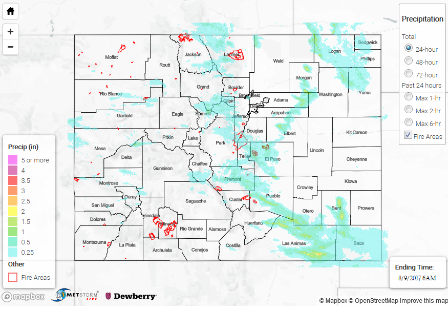
Fremont and El Paso County reported hail up to 0.88 inches in diameter. Over Woodland Park, heavy rain fell with a report of 1 inch in 10 minutes that caused street flooding. Over Colorado Springs, a USGS gage at Cheyenne Creek recorded 1.11 inches in 1 hour. In the eastern plains, the storm over Las Animas produced up to 3 inches of rain. 1-hour rain rates were as high as 2.5 inches. Over the western portion of the state, two SNOTEL stations recorded over an inch of rain. The first was near Steamboat Lake (1.5 inches) and the other in Grand Mesa National Forest (1.1 inches).
Concern remains over the Arkansas River basin. With multiple days of heavy rainfall and a continued active weather pattern, there is a dangerous flooding potential. This will continue to be monitored closely and any updates will be posted to our pages here and our Twitter account @COFloodUpdates.
To see how much rain fell in your area yesterday, take a look at the State Precipitation Map below.