Issue Date: Friday, August 11, 2017
Issue Time: 10:35AM MDT
Summary
Favorable thunderstorm dynamics and high moisture brought severe weather to the eastern plains yesterday. Storms formed over the mountains around midday and moved SE into high instability and shear. A few isolated supercells were able to form that dropped large hail, heavy precipitation and gusty winds. Eventually, these stormed merged and made a line of severe thunderstorms along the cold front that dropped south over the state in the evening and overnight hours. This storms ended just after midnight, but not before dropping impressive amounts of rain even though they were fast moving.
The highest precipitation amounts over the mountains were along the Northern Front Range where 0.95 inches fell at a CoCoRaHS gage. In the Fort Collins area, gusty winds and hail up to 0.88 inches in diameter were reported with the thunderstorms. Just north of Fort Collins, 1.43 inches of rain fell over a 30 minute period. Over Greeley, 2.38 inches of rain in 45 minutes was reported. Radar estimates in this area are as high as 2.2 inches. Further south, over the urban portion of El Paso County, a trained spotter recorded 1.1 inches in 20 minutes accompanied by 0.88 inch diameter hail. As the thunderstorms moved into the plains, and over more favorable severe thunderstorm dynamics, they dropped impressive rain and hail. Prowers and Bent County reported 2.75 inch diameter hail (baseball size)! Rainfall just over 3.5 inches was estimated by radar with a report of 2.7 inches in Walsh, Colorado.
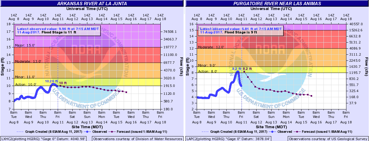
Two gages along the Arkansas River basin have reached action stage yesterday. The first was the Purgatoire River near Las Animas and the second was the Arkansas River at La Junta. Rainfall over this basin is forecasted through the weekend, and with saturated soils, runoff will be high. There is a strong chance for riverine flooding at some point this weekend, though no major flooding is forecasted. We will continue monitoring the gages and any updates will be posted to our daily Flood Threat Bulletin and Twitter account @COFloodUpdates.
To see how much rain fell in your neighborhood, take a peek at the State Precipitation Map below.
