SPM 08-16-2017: Moisture and Dynamics Aid in Heavy Precipitation

Issue Date: Wednesday, August 16, 2017
Issue Time: 09:55AM MDT

Summary

Above normal low-level moisture continued to hold on over the northeast plains yesterday. A large-scale trough was positioned over the west coast that helped support a surface low pressure system over Colorado. The low pressure helped pull in moist air on its eastern side for a couple rounds of showers and thunderstorms yesterday, but the heaviest precipitation remained just east over Nebraska. A cold front moved through the area last night, and the upper-level trough continues to move through the state this morning. This trough is supporting light showers over the eastern plains.

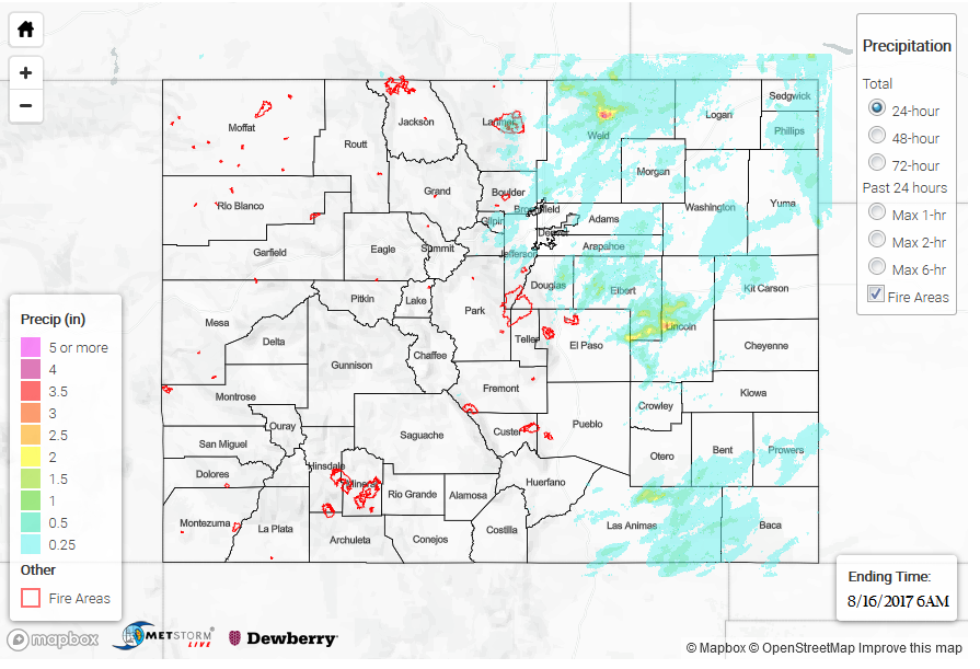
With favorable dynamic forcing, many of the storms of the plains yesterday became severe and produced gusty winds with hail up to 2 inches in diameter. There were also two Flash Flood Warnings for thunderstorms over Lincoln and Kit Carson County and a few other Areal Flood Advisories for the thunderstorms due slower storm motion.  Storm totals over Lincoln County were as high as 3 inches with 1-hour rain rates up to 2.5 inches proving storms yesterday to be efficient precipitation producers. A report just outside of Hugo stated that there was 3 feet of standing water in a field and water over roadways. In Weld County, just over 4 inches were estimated by radar with 1 hour rain rates up to 3.5 inches. There were no gages in the area to confirm totals and most of the heavy precipitation fell in ungaged areas. The highest CoCoRaHS observation over Sedgwick County where 1.22 inches was recorded for the 24-hour period. Over the mountains, the scattered storms favored the northern portion of the state. Due to the lower moisture environment, heavy rainfall was not forecasted. The largest 24-hour total was recorded over Larimer (0.63 inches), but all other reports were under 0.5 inches.

To see how much rain fell over your area, check out the State Precipitation Map below.

Click Here For Map Overview

The map below shows radar-estimated, rainfall gage-adjusted Quantitative Precipitation Estimates (QPE) across Colorado. The map is updated daily during the operational season (May 1 – Sep 30) by 11AM. The following six layers are currently available: 24-hour, 48-hour and 72-hour total precipitation, as well as maximum 1-hour, 2-hour and 6-hour precipitation over the past 24 hour period (to estimate where flash flooding may have occurred). The accumulation ending time is 6AM of the date shown in the bottom right corner. Also shown optionally are fire burn areas since 2012. The home button in the top left corner resets the map to the original zoom.

Note: We have identified a possible underestimation in QPE over the southwest part of the state. We are working to on this issue, and will provide an update as soon as possible.

SPM 08-15-2017: Worst Case Scenario Rainfall Rates Realized

Issue Date: Tuesday, August 15, 2017
Issue Time: 11AM MDT

Summary:

It is no secret that heavy rainfall and flood forecasting is an imperfect (though improving) science and sometimes Mother Nature throws us a curveball. Monday afternoon was one of those times. Every morning, we produce a “worst-case scenario” rainfall estimate across the state using our ensemble guidance. Very often, this is an excellent tool for depicting realistic maximum rainfall rates, as well as the locations most likely to be impacted. Yesterday, our guidance for max 3-hour rainfall looked like this:

There was a pocket of higher values across up to 2.25 inches in 3 hours in eastern Colorado where some members of the ensemble indicated a potential convergence zone developing. However, this intensity is not all that noteworthy especially given its presumed low chance of occurrence based on our morning analysis. Also note the higher values just across the border in western KS and NE.

In reality, not only did the convergence zone materialize stronger than expected, it was also significantly farther west than expected, extending almost to Denver metro. Thus, yesterday afternoon’s almost all of yesterday’s individual storms ended up being on the higher side of guidance, or even above it. Moderate rainfall amounts were observed across parts of the higher terrain where up to 0.6 inches of rainfall fell. However, across the northern part of the Palmer Ridge, some much more impressive storms developed. The strongest cell in the state occurred over Kit Carson county as an outflow boundary moved in from NE. Slowly moving cells with access to plenty of “fresh” moist air from the south hung out right along I-70 for a 2-3 hour period. Max 1-hour rainfall rates above 2 inches were common, though the more impressive tally was 4+ inches of rainfall estimated over a roughly 2 hour period. Unfortunately, there were no official gage reports above 1.5 inches though significant street flooding was reported near Vona, which likely required much more than 1.5 inches of rainfall to produce. Another line of storms formed farther west, though rainfall rates with these was significantly lower, up to 1.5 inches per hour. Numerous flash flood warnings were posted for this activity yesterday afternoon.

SPM 08-14-2017: Another Round of Severe Weather for the Eastern Plains

Issue Date: Monday, August 14, 2017
Issue Time: 09:50AM MDT

Summary

A lee trough set up yesterday that helped pull in moisture on its east side and brought drier conditions to its west. Dew points over Denver yesterday afternoon were around 40F, while on the far eastern plains, dew points were in the mid-60s. These lower moisture areas produced more gusty winds with storms that came through than heavy rainfall. Storms began firing over the mountains around 1PM as well as over the Southeast Plains along a surface boundary. Eventually the storms over the Northeast Plains merged and moved S/SE through the evening hours and exited over the Kansas border around 1AM. Showers over the mountains quickly ended after sundown.

A severe thunderstorm watch was issued for the eastern plains due to increased moisture, shear and a good amount of instability. Thunderstorms that made it into the far eastern plains, quickly became severe. Over Prowers County, hail up to 2.75 inches was recorded. These storms also had strong winds. Over Burlington, a 66 mph gust was recorded at a weather station. Storm totals in the area were estimated at 1.6 inches with 1-hour rain rates around the same amount. Two flood advisories were issued yesterday for Rio Blanco and Garfield County. Precipitation totals in the area were estimated at 1.4 inches. As of this morning, there were no flood reports. The gage at La Junta along the Arkansas River continues to run at Action Stage this morning, but flow is forecasted to decrease throughout the day.

To see how much rain fell in your neighborhood, check out the State Precipitation Map below.

Click Here For Map Overview

The map below shows radar-estimated, rainfall gage-adjusted Quantitative Precipitation Estimates (QPE) across Colorado. The map is updated daily during the operational season (May 1 – Sep 30) by 11AM. The following six layers are currently available: 24-hour, 48-hour and 72-hour total precipitation, as well as maximum 1-hour, 2-hour and 6-hour precipitation over the past 24 hour period (to estimate where flash flooding may have occurred). The accumulation ending time is 6AM of the date shown in the bottom right corner. Also shown optionally are fire burn areas since 2012. The home button in the top left corner resets the map to the original zoom.

Note: We have identified a possible underestimation in QPE over the southwest part of the state. We are working to on this issue, and will provide an update as soon as possible.

SPM 08-13-2017: Large Hail, one Tornado and Local, Heavy Rainfall for the Palmer Ridge and Northeast Plains

Issue Date: Sunday, August 13, 2017
Issue Time: 10:45AM MDT

Summary

Warmer temperatures and sunny skies helped build more instability over the Northern portion of the state yesterday. Scattered storms formed over the mountains (favoring the north) and outflow boundaries helped initiate additional storms over the adjacent plains. Over the Northeast Plains, a short wave moved over the state in the afternoon in an area of high instability and shear where storms quickly become severe. Large hail and gusty winds were the main threats with heavy, local rainfall also falling. As these storms moved to the SE, they merged with other storms moving east along the Palmer Divide. This line of convection moved S/SE and eventually exited the state around midnight.

Drier mid and lower levels helped confine the higher precipitation totals to the eastern plains. Over the mountains, a Flash Flood Warning was issued for Rio Blanco County. Radar estimates are as high as 1.6 inches, but no flooding was reported. Over the Front Range, the heavier precipitation fell over the adjacent plains along the Palmer Divide. A CoCoRaHS station recorded 3.17 inches of rain over El Paso County with radar estimates as high as 4 inches (1 in 50 year event). An Areal Flood Advisory was issued but no reports of flooding as of this morning. Over the Denver Metro area rain rates of 0.5 inches in 10 minutes occurred, but storms were short-lived. Further east over the plains, 2 inch hail and gusty winds accompanied the severe thunderstorms. There were a couple of tornado reports in Washington County near Anton, Colorado. 1-hour rain rates were as high as 1.5 inches with storm total rainfall estimated at 2 inches. As of this morning, there were no flooding reports.

The Arkansas River gage at La Junta continues to run at Action stage and will be closely monitored throughout the day as widespread rainfall is likely over the Southeast Plains. Please see the Flood Threat Bulletin for more details.

To see how much rain fell in your area, scroll down and take a peek at the State Precipitation Map below.