SPM 05-19-2018: Ample Moisture and Broad-Scale Support for Numerous Showers/Thunderstorms

Issue Date: Saturday, May 19th, 2018
Issue Time: 9:30 AM MDT

Summary:

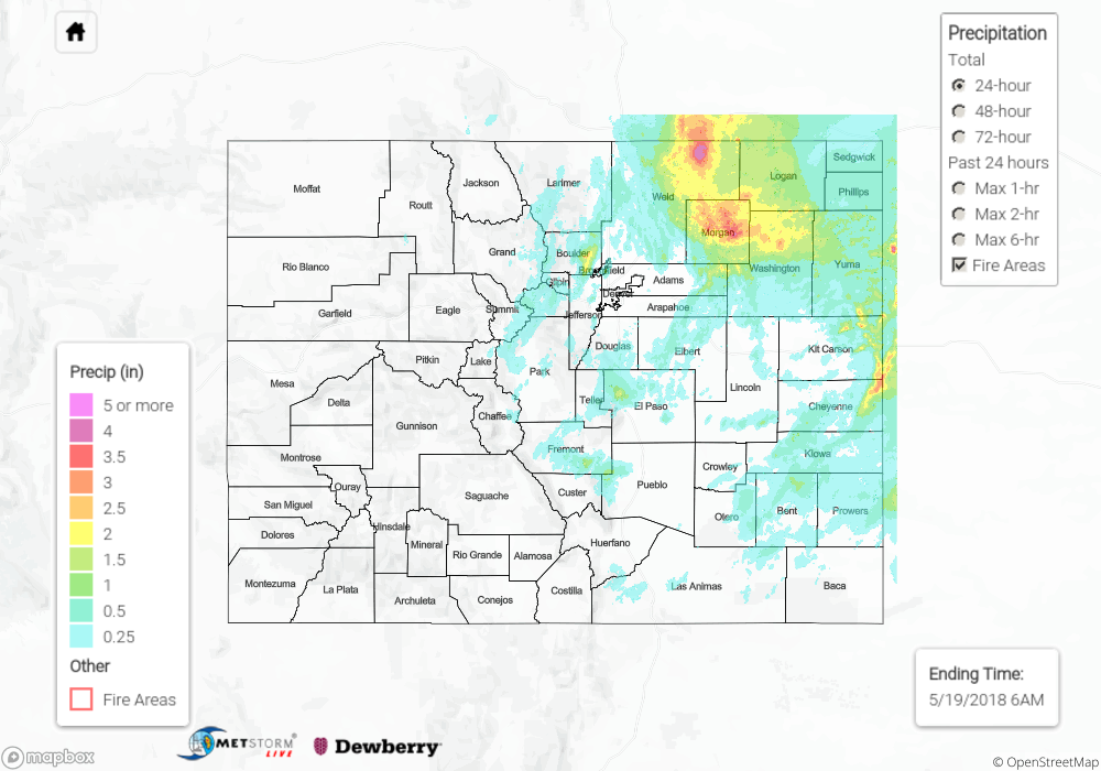
Much of the state got in on the rain act yesterday, especially east of the Continental Divide where lower-level moisture and instability was best. Storms got an early start over the Front Range, as is usual, beginning during the early afternoon hours. Eventually, storms slowly made their way eastward across the Urban Corridor and then over the Plains. Heavy rainfall and plenty of hail were the main impacts from stronger thunderstorms yesterday, producing isolated street/field/small stream flooding across portions of the Urban Corridor, Front Range, and Northeast Plains.

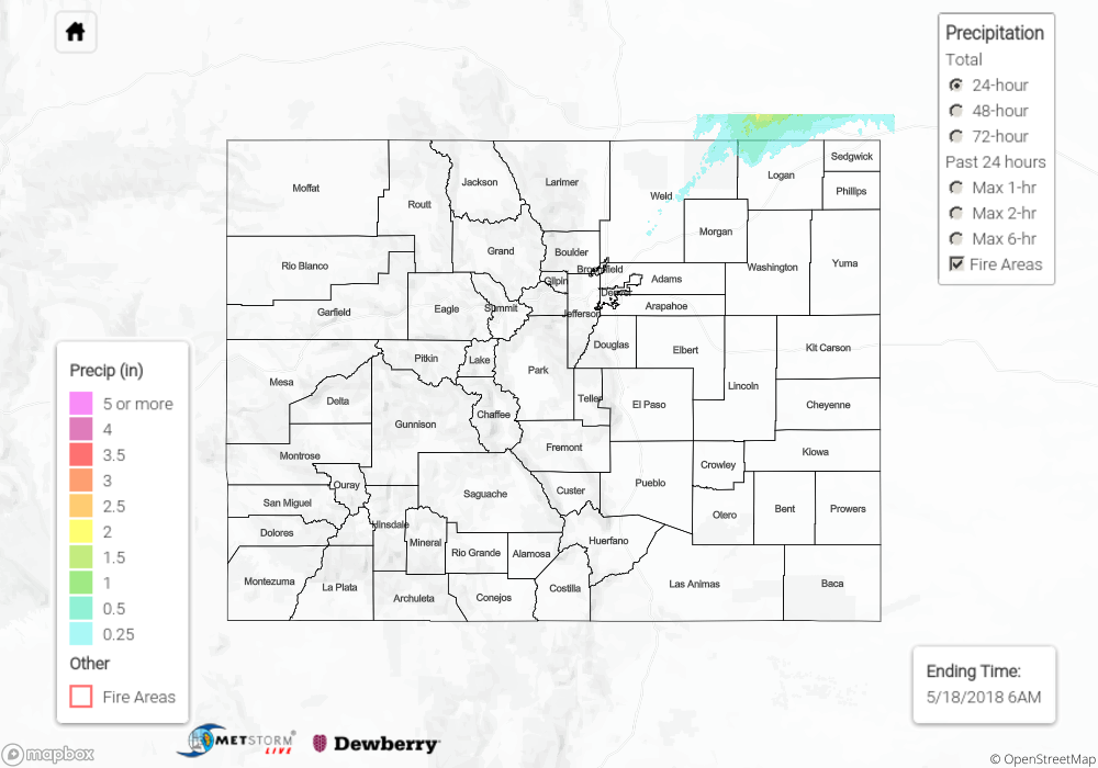
West of the Continental Divide, showers/thunderstorms were more of the garden variety, with the majority of activity over the Northwest Slope, Northern Mountains, and Central Mountains. Elsewhere, only a few isolated showers were mustered.

Numerous showers and an isolated thunderstorm or two continue across portions of the Front Range, Urban Corridor, Palmer Ridge, Northeast Plains, and Southeast Plains this morning. For a look at precipitation estimates in your area, please see our State Precipitation Map below.

Click Here For Map Overview

The map below shows radar-estimated, rainfall gage-adjusted Quantitative Precipitation Estimates (QPE) across Colorado. The map is updated daily during the operational season (May 1 – Sep 30) by 11AM. The following six layers are currently available: 24-hour, 48-hour and 72-hour total precipitation, as well as maximum 1-hour, 2-hour and 6-hour precipitation over the past 24 hour period (to estimate where flash flooding may have occurred). The accumulation ending time is 6AM of the date shown in the bottom right corner. Also shown optionally are fire burn areas since 2012. The home button in the top left corner resets the map to the original zoom.

Note: We have identified a possible underestimation in QPE over the southwest part of the state. We are working to on this issue, and will provide an update as soon as possible.

SPM 05-18-2018: Overnight MCS Rainfall Confined to Nebraska Panhandle

Issue Date: Friday, May 18, 2018
Issue Time: 10:25AM MDT

Summary:

Late day convergence along a boundary helped fuel some isolated thunderstorms over the northern Urban Corridor and Northeast Plains yesterday. These elevated thunderstorms produced stronger winds rather than hefty rainfall. A gust of 40 mph was recorded at the Greeley airport, and 1 inch hail was reported in Peetz. As the storms tracked to the east/northeast, they exited the state by 9PM into the panhandle of NE. Heavy, overnight convection occurred in the panhandle into this morning. A small portion of this convection sneaked its way back into Weld County at the Colorado/Nebraska state line. Radar estimates over the area were 1 inch.

Flooding was not reported Thursday. To see rainfall estimates in your area, scroll down to the State Precipitation Map below.

Click Here For Map Overview

The map below shows radar-estimated, rainfall gage-adjusted Quantitative Precipitation Estimates (QPE) across Colorado. The map is updated daily during the operational season (May 1 – Sep 30) by 11AM. The following six layers are currently available: 24-hour, 48-hour and 72-hour total precipitation, as well as maximum 1-hour, 2-hour and 6-hour precipitation over the past 24 hour period (to estimate where flash flooding may have occurred). The accumulation ending time is 6AM of the date shown in the bottom right corner. Also shown optionally are fire burn areas since 2012. The home button in the top left corner resets the map to the original zoom.

Note: We have identified a possible underestimation in QPE over the southwest part of the state. We are working to on this issue, and will provide an update as soon as possible.

SPM 05-17-2018: Warm and Dry as the Upper Ridge Won the Day

Issue Date: Thursday, May 17th, 2018
Issue Time: 9:30 AM MDT

Summary:

As far as precipitation is concerned, yesterday was one of the more boring days in recent weeks. Dry and warm conditions dominated the day as the upper ridge, and associated dry air, capped off the environment and suppressed any potential development. A few streaks of virga painted the sky during the late afternoon and evening, but that was all Mother Nature could muster. With the capped environment, a moisture influx was able to prime the atmosphere for a couple strong-to-severe thunderstorms today over the eastern plains – be sure to check in with the FTB for more information.

Flash flooding was not reported yesterday. For a look at precipitation estimates in your area, please see our State Precipitation Map below.

Click Here For Map Overview

The map below shows radar-estimated, rainfall gage-adjusted Quantitative Precipitation Estimates (QPE) across Colorado. The map is updated daily during the operational season (May 1 – Sep 30) by 11AM. The following six layers are currently available: 24-hour, 48-hour and 72-hour total precipitation, as well as maximum 1-hour, 2-hour and 6-hour precipitation over the past 24 hour period (to estimate where flash flooding may have occurred). The accumulation ending time is 6AM of the date shown in the bottom right corner. Also shown optionally are fire burn areas since 2012. The home button in the top left corner resets the map to the original zoom.

Note: We have identified a possible underestimation in QPE over the southwest part of the state. We are working to on this issue, and will provide an update as soon as possible.

SPM 05-16-2018: Scattered Thunderstorms Rumbled, Bringing Periods of Heavy Rain and Hail

Issue Date: Wednesday, May 16th, 2018
Issue Time: 9:30 AM MDT

Summary:

The upper-level low finally began to break down and ejected a shortwave disturbance that passed overhead yesterday. This disturbance worked in concert with daytime heating and orographic support to drive the development of isolated-to-scattered thunderstorms along/east of the Front Range/Southeast Mountains and over the plains. The bulk of activity occurred during the afternoon/evening hours yesterday, but a few storms were able to keep chugging along into the early morning hours. Storms over the lower elevations of the Urban Corridor (south of Douglas County) and Southeast Plains were the most efficient rainfall producers thanks to having access to deeper moisture than those to the north. The largest hail report of the day came from 1 mile SW of Atwood (Logan County) where 1.75 inch diameter hail was observed by a trained spotter. According to CoCoRaHS observers, the big winners for rainfall are as follows:

El Paso County: 1.33 inches
Otero County: 1.21 inches
Cheyenne County: 0.85 inches
Prowers County: 0.72 inches

Flash flooding was not reported yesterday. For a look at precipitation estimates in your area, please see our State Precipitation Map below.

Click Here For Map Overview

The map below shows radar-estimated, rainfall gage-adjusted Quantitative Precipitation Estimates (QPE) across Colorado. The map is updated daily during the operational season (May 1 – Sep 30) by 11AM. The following six layers are currently available: 24-hour, 48-hour and 72-hour total precipitation, as well as maximum 1-hour, 2-hour and 6-hour precipitation over the past 24 hour period (to estimate where flash flooding may have occurred). The accumulation ending time is 6AM of the date shown in the bottom right corner. Also shown optionally are fire burn areas since 2012. The home button in the top left corner resets the map to the original zoom.

Note: We have identified a possible underestimation in QPE over the southwest part of the state. We are working to on this issue, and will provide an update as soon as possible.