SPM 08-02-2022: Heavy Rain for Central, Southern Mountains

Issue Date: Tuesday, August 2nd, 2022
Issue Time: 11:15 AM MDT

Summary:

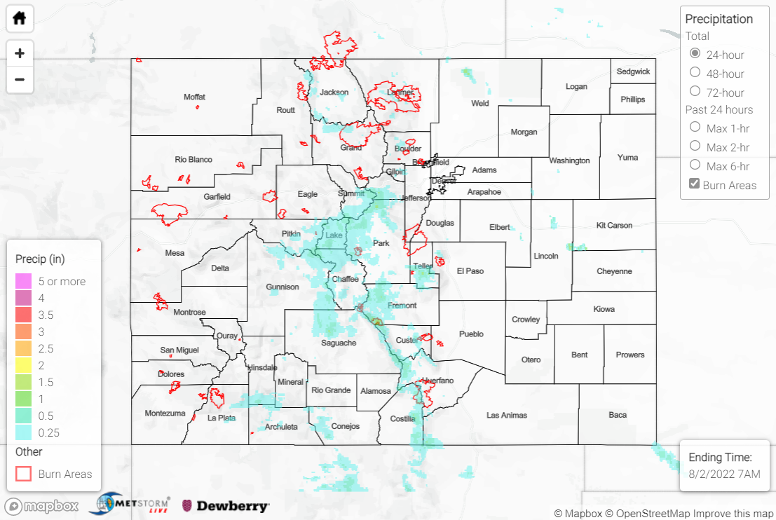
Monday saw showers and storms mostly limited to the high elevations, with the heaviest rain falling across the mountains in central and southern portions of the state.

From the Central Mountains southeastward across the Southeast Mountains, QPE data suggests localized amounts up to 2” occurred. Flash Flood Warnings were issued for the Decker burn scar, Hayden Pass burn scar (2016), and Spring Creek burn scar, but no flooding was reported. A Flash Flood Warning, with no flooding reported, was also issued for northwest Gunnison and west-central Pitkin Counties. Notable rainfall observations in this region include 1.20” near Independence Pass, 1.06” near Breckenridge, 0.90” near Medano Pass, and 0.80” near Fort Garland.

Farther southwest across the San Juan Mountains, QPE data suggests 0.50-1.00” of rain was observed, but these amounts are likely underestimated as the Grand Junction radar remained offline yesterday. A Flash Flood Warning and Flood Advisory were issued for northwest Archuleta, south-central Hinsdale, and east-central La Plata Counties, with a debris flow reported across County Road 501. State Highway 114 was also reported as closed due to flooding approximately 12 miles west-northwest of Saguache. Notable rainfall observations in the San Juans include 1.95” near Durango and 1.82” near Rico.

Lighter precipitation was observed across the Northern Mountains and northern Front Range, where no flooding was reported but Flood Advisories were issued for both the East Troublesome and Cameron Peak burn scars. QPE data suggests amounts of up to 0.50”, with an automated gauge north of Hot Sulphur Springs measuring 0.35”.

If you observe flooding in your area, remember to use the “Report a Flood” page to make any flood reports when you can safely do so. For precipitation estimates in our area, check out the map below.
Click Here For Map Overview

The map below shows radar-estimated, rainfall gage-adjusted Quantitative Precipitation Estimates (QPE) across Colorado. The map is updated daily during the operational season (May 1 – Sep 30) by 11AM. The following six layers are currently available: 24-hour, 48-hour and 72-hour total precipitation, as well as maximum 1-hour, 2-hour and 6-hour precipitation over the past 24 hour period (to estimate where flash flooding may have occurred). The accumulation ending time is 7AM of the date shown in the bottom right corner. Also shown optionally are vulnerable fire burn areas (post 2012), which are updated throughout the season to include new, vulnerable burn areas. The home button in the top left corner resets the map to the original zoom.

SPM 08-01-2022: Rain from Northeast to Southwest, Calmer Sunday

Issue Date: Monday, August 1st, 2022
Issue Time: 9:50 AM MDT

Summary:

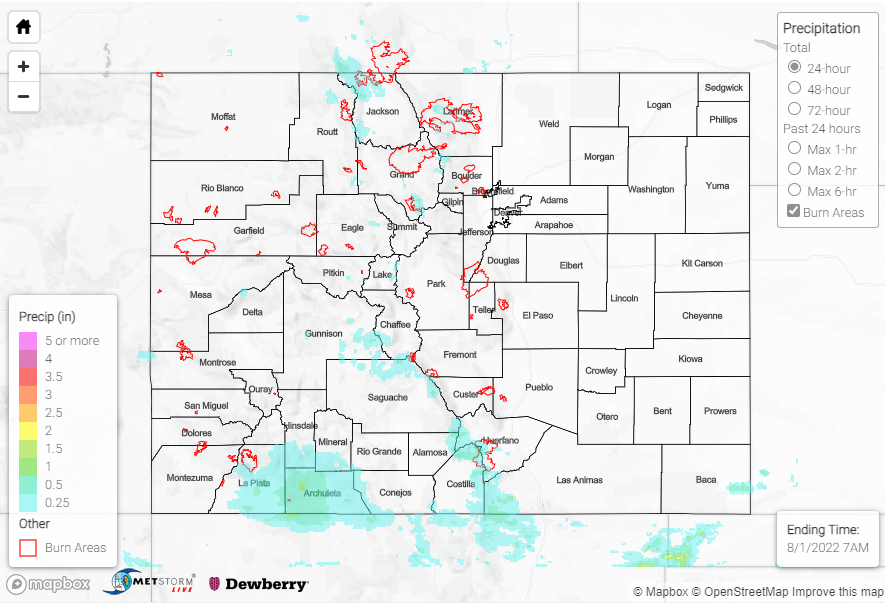
Sunday saw less rain than the last few days, with the majority of precipitation from the southwest corner of the state up to the northeast. The Southern Plains and Northwest Slope stayed quite dry.

East of Chromo near the southern border saw the most rain yesterday, reporting up to 0.91” of precipitation, along with hail in the area. The rest of the Southern Slope received between 0-0.20” roughly, with a few outliers such as as 0.52” west of Durango, and 0.39” in Placerville, among others. One flood advisory was issued near Durango, but flooding was reported. The Northern Plains saw second highest totals – up to 0.83” in Fairfield via CoCoRaHS.

Across the Central Mountains, Front Range, and Urban Corridor, many areas received between 0″ and 0.2”. Some more notable amounts include:

-0.78” near Aspen
-0.28” near Leadville
-0.51” in Divide
-0.24” in Briggsdale
-up to 0.32” near Fort Collins

There were two flood advisories for the Cameron Peak and East Troublesome burn scars, but no flooding has been reported. In other news, a small fire broke out in Larimer County on Wild Wing Drive, issuing evacuations for residents. Residents were able to return home later that day as the fire was quickly contained.

As a reminder, the Grand Junction radar is down, which means QPE totals in the western part of the state will be underestimated.

No flooding was reported today. If you observe flooding in your area, remember to use the “Report a Flood” page to make any flood reports when you can safely do so. For precipitation estimates in our area, check out the map below.
Click Here For Map Overview

The map below shows radar-estimated, rainfall gage-adjusted Quantitative Precipitation Estimates (QPE) across Colorado. The map is updated daily during the operational season (May 1 – Sep 30) by 11AM. The following six layers are currently available: 24-hour, 48-hour and 72-hour total precipitation, as well as maximum 1-hour, 2-hour and 6-hour precipitation over the past 24 hour period (to estimate where flash flooding may have occurred). The accumulation ending time is 7AM of the date shown in the bottom right corner. Also shown optionally are vulnerable fire burn areas (post 2012), which are updated throughout the season to include new, vulnerable burn areas. The home button in the top left corner resets the map to the original zoom.

SPM 07-31-2022: More Heavy Rain for Southern High Elevations

Issue Date: Sunday, July 31st, 2022
Issue Time: 9:30 AM MDT

Summary:

The upper-level ridge was shunted southward on Saturday, limiting the extent of monsoonal moisture into northern portions of the state. As such, storms were mostly limited to the high southern elevations, and the highest elevations of the northern Front Range. Storms developed by mid-afternoon, with dry air and stability over the Plains limiting convection there.

The heaviest rain was observed across southern portions of the state, particularly the southern Southwest Slope, San Juan Mountains, and Southeast Mountains, as well as over higher elevations in the Grand Valley. The Grand Junction radar remains out, meaning QPE data is likely underestimated, but amounts of 1-2” appear to have been common based on rain gauge data. Some notable observations include:

• 1.68” southwest of Cortez
• 1.41” near Bayfield
• 1.28” near Grand Mesa
• 1.14” near San Luis Lake
• 1.10” near both Durango and Pagosa Springs
• 0.98” west of Trinidad

A series of Flood Advisories were issued for areas south and west of Durango based on satellite and lightning data, but no flooding was reported. Further north, a Flash Flood Warning was issued for northern Gunnison and northwestern Pitkin County, with local law enforcement reporting a mudslide over Highway 133 north of Redstone near mile marker 57. A Flash Flood Warning was also issued for portions of the Pine Gulch burn scar, but no flooding was reported. Multiple rivers in the southern Southwest Slope continue experiencing much above normal flows after rainfall the past few days, including the Mancos, San Juan, Los Pinos, and Piedra Rivers, but no flooding has been reported.

For the northern Front Range, multiple Flood Advisories were issued for portions of the Cameron Peak burn scar, but no flooding was reported; QPE data suggests amounts of up to 0.50-0.75”. In the extreme southeastern tip of the state, an isolated storm in east-central Baca County prompted a Flash Flood Warning after dropping 1.54” of rain per a trained storm spotter, but no flooding was reported.

If you observe flooding in your area, remember to use the “Report a Flood” page to make any flood reports when you can safely do so. For precipitation estimates in our area, check out the map below.
Click Here For Map Overview

The map below shows radar-estimated, rainfall gage-adjusted Quantitative Precipitation Estimates (QPE) across Colorado. The map is updated daily during the operational season (May 1 – Sep 30) by 11AM. The following six layers are currently available: 24-hour, 48-hour and 72-hour total precipitation, as well as maximum 1-hour, 2-hour and 6-hour precipitation over the past 24 hour period (to estimate where flash flooding may have occurred). The accumulation ending time is 7AM of the date shown in the bottom right corner. Also shown optionally are vulnerable fire burn areas (post 2012), which are updated throughout the season to include new, vulnerable burn areas. The home button in the top left corner resets the map to the original zoom.

SPM 07-30-2022: Heavy Rain for Portions of I-25 Corridor, Southern High Terrain, Far Eastern Plains

Issue Date: Saturday, July 30th, 2022
Issue Time: 11:45 AM MDT

Summary:

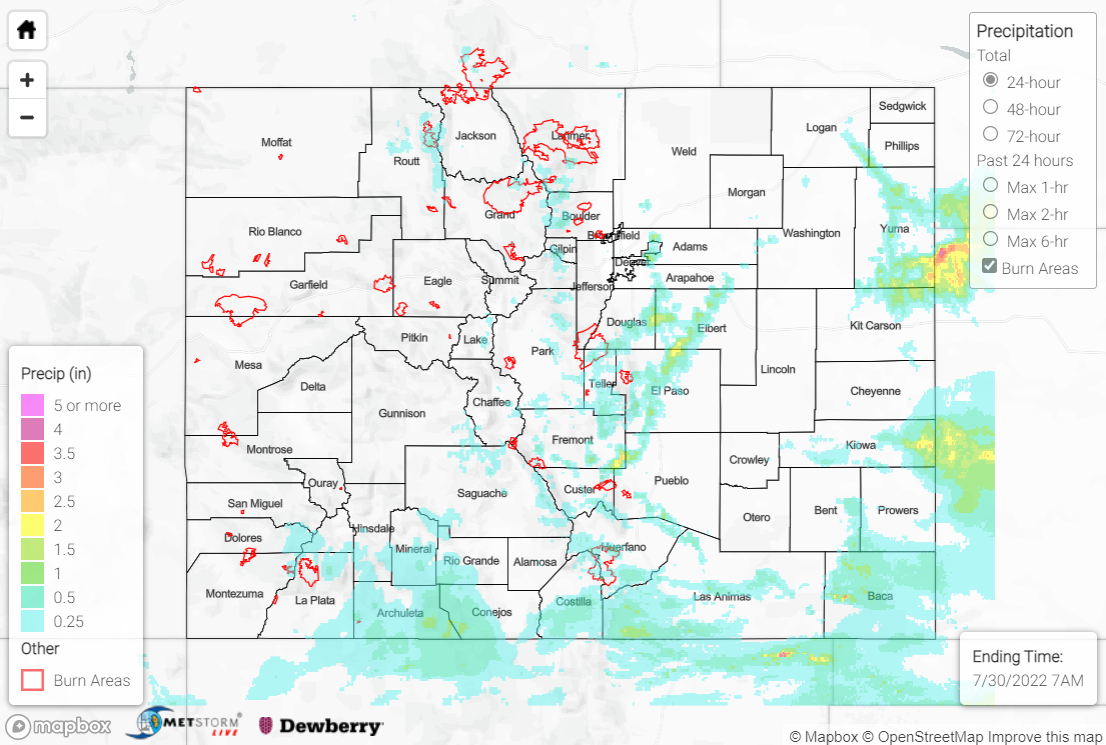
With plentiful monsoonal moisture remaining anchored over Colorado, showers and storms were once again able to develop over the high terrain by early afternoon on Friday. Diurnal heating and weak disturbances aloft combined to get convection going, with the heaviest rain falling over the southern Urban Corridor/western Palmer Ridge, far eastern Plains, and far southern mountains/foothills.

A Flash Flood Warning was issued for southern portions of the Cameron Peak burn scar, with an automated gauge near Glen Haven measuring 0.91”; 0.75” of this total fell in just 20 minutes, which has an estimated ARI of over 10 years. An emergency manager reported flood waters washing over County Road 43 at Miller Fork Crossing, although no debris flows were reported. Another Flash Flood Warning was issued for portions of the East Troublesome burn scar, but no flooding was reported. CoCoRaHS observers reported over an inch of rain just south of Estes Park.

QPE data suggests amounts up to 2+” fell along the I-25 corridor south of Denver and north of Pueblo, with multiple Flash Flood Warnings and Flood Advisories issued in the area. A trained spotter reported an intersection under up to 8” of water near Falcon, while members of the public reported Peyton Highway flooded 5 miles north of Peyton. Notable rainfall totals include:

• 2.40” near Elizabeth
• 2.32” near Peyton
• 1.70” near Franktown
• 1.33” near Colorado Springs

Further south over the San Juan Mountains, Southeast Mountains, and Palmer Ridge, QPE data suggests amounts up to 1”, although amounts are likely underestimated over the San Juans thanks to the Grand Junction radar outage. Several rivers, creeks, and streams in the region are running much above normal after the rainfall the last several days, including the San Juan River and Piedra River, although no flooding has been reported. Notable rainfall totals include:

• 1.31” southeast of Pagosa Springs
• 1.15” near Mesa Verde National Park
• 1.09” west of Trinidad

For the far eastern Plains, QPE data suggests amounts up to 2.5” were observed in some locations, particularly across Yuma and eastern Kiowa Counties. Rain gauge observations are sparse, but a CoCoRaHS observer measured 0.84” near Burlington, while an automated gauge near Idalia measured 0.88”.

Lastly, check out the video below of a landspout tornado that occurred east of Denver near Buckley Air Force Base!

If you observe flooding in your area, remember to use the “Report a Flood” page to make any flood reports when you can safely do so. For precipitation estimates in our area, check out the map below.

Click Here For Map Overview

The map below shows radar-estimated, rainfall gage-adjusted Quantitative Precipitation Estimates (QPE) across Colorado. The map is updated daily during the operational season (May 1 – Sep 30) by 11AM. The following six layers are currently available: 24-hour, 48-hour and 72-hour total precipitation, as well as maximum 1-hour, 2-hour and 6-hour precipitation over the past 24 hour period (to estimate where flash flooding may have occurred). The accumulation ending time is 7AM of the date shown in the bottom right corner. Also shown optionally are vulnerable fire burn areas (post 2012), which are updated throughout the season to include new, vulnerable burn areas. The home button in the top left corner resets the map to the original zoom.