Issue Date: Sunday, July 31st, 2022
Issue Time: 9:30 AM MDT
Summary:
The upper-level ridge was shunted southward on Saturday, limiting the extent of monsoonal moisture into northern portions of the state. As such, storms were mostly limited to the high southern elevations, and the highest elevations of the northern Front Range. Storms developed by mid-afternoon, with dry air and stability over the Plains limiting convection there.
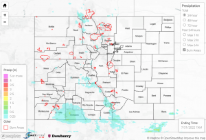
The heaviest rain was observed across southern portions of the state, particularly the southern Southwest Slope, San Juan Mountains, and Southeast Mountains, as well as over higher elevations in the Grand Valley. The Grand Junction radar remains out, meaning QPE data is likely underestimated, but amounts of 1-2” appear to have been common based on rain gauge data. Some notable observations include:
• 1.68” southwest of Cortez
• 1.41” near Bayfield
• 1.28” near Grand Mesa
• 1.14” near San Luis Lake
• 1.10” near both Durango and Pagosa Springs
• 0.98” west of Trinidad
A series of Flood Advisories were issued for areas south and west of Durango based on satellite and lightning data, but no flooding was reported. Further north, a Flash Flood Warning was issued for northern Gunnison and northwestern Pitkin County, with local law enforcement reporting a mudslide over Highway 133 north of Redstone near mile marker 57. A Flash Flood Warning was also issued for portions of the Pine Gulch burn scar, but no flooding was reported. Multiple rivers in the southern Southwest Slope continue experiencing much above normal flows after rainfall the past few days, including the Mancos, San Juan, Los Pinos, and Piedra Rivers, but no flooding has been reported.
For the northern Front Range, multiple Flood Advisories were issued for portions of the Cameron Peak burn scar, but no flooding was reported; QPE data suggests amounts of up to 0.50-0.75”. In the extreme southeastern tip of the state, an isolated storm in east-central Baca County prompted a Flash Flood Warning after dropping 1.54” of rain per a trained storm spotter, but no flooding was reported.
If you observe flooding in your area, remember to use the “Report a Flood” page to make any flood reports when you can safely do so. For precipitation estimates in our area, check out the map below.
