Issue Date: Saturday, July 30th, 2022
Issue Time: 11:45 AM MDT
Summary:
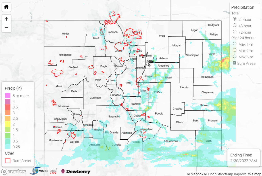
With plentiful monsoonal moisture remaining anchored over Colorado, showers and storms were once again able to develop over the high terrain by early afternoon on Friday. Diurnal heating and weak disturbances aloft combined to get convection going, with the heaviest rain falling over the southern Urban Corridor/western Palmer Ridge, far eastern Plains, and far southern mountains/foothills.
A Flash Flood Warning was issued for southern portions of the Cameron Peak burn scar, with an automated gauge near Glen Haven measuring 0.91”; 0.75” of this total fell in just 20 minutes, which has an estimated ARI of over 10 years. An emergency manager reported flood waters washing over County Road 43 at Miller Fork Crossing, although no debris flows were reported. Another Flash Flood Warning was issued for portions of the East Troublesome burn scar, but no flooding was reported. CoCoRaHS observers reported over an inch of rain just south of Estes Park.
QPE data suggests amounts up to 2+” fell along the I-25 corridor south of Denver and north of Pueblo, with multiple Flash Flood Warnings and Flood Advisories issued in the area. A trained spotter reported an intersection under up to 8” of water near Falcon, while members of the public reported Peyton Highway flooded 5 miles north of Peyton. Notable rainfall totals include:
• 2.40” near Elizabeth
• 2.32” near Peyton
• 1.70” near Franktown
• 1.33” near Colorado Springs
Further south over the San Juan Mountains, Southeast Mountains, and Palmer Ridge, QPE data suggests amounts up to 1”, although amounts are likely underestimated over the San Juans thanks to the Grand Junction radar outage. Several rivers, creeks, and streams in the region are running much above normal after the rainfall the last several days, including the San Juan River and Piedra River, although no flooding has been reported. Notable rainfall totals include:
• 1.31” southeast of Pagosa Springs
• 1.15” near Mesa Verde National Park
• 1.09” west of Trinidad
For the far eastern Plains, QPE data suggests amounts up to 2.5” were observed in some locations, particularly across Yuma and eastern Kiowa Counties. Rain gauge observations are sparse, but a CoCoRaHS observer measured 0.84” near Burlington, while an automated gauge near Idalia measured 0.88”.
Lastly, check out the video below of a landspout tornado that occurred east of Denver near Buckley Air Force Base!
Here is one of many videos we’ve received from the landspout that occurred a couple of miles north of the Buckley Air Force Base earlier this afternoon. Thanks to @NWS_BaltWash meteorologist Brandon Fling (@fling40) for doing a little storm spotting for us! #cowx pic.twitter.com/Sr6BfNBVFo
— NWS Boulder (@NWSBoulder) July 30, 2022
If you observe flooding in your area, remember to use the “Report a Flood” page to make any flood reports when you can safely do so. For precipitation estimates in our area, check out the map below.
