SPM 07-08-2019: Afternoon Rainfall Returned to the Mountains and Adjacent Plains with Widespread Measurable Rainfall for Western CO

Issue Date: Monday, July 8th, 2019
Issue Time: 10:00AM MDT

Summary:

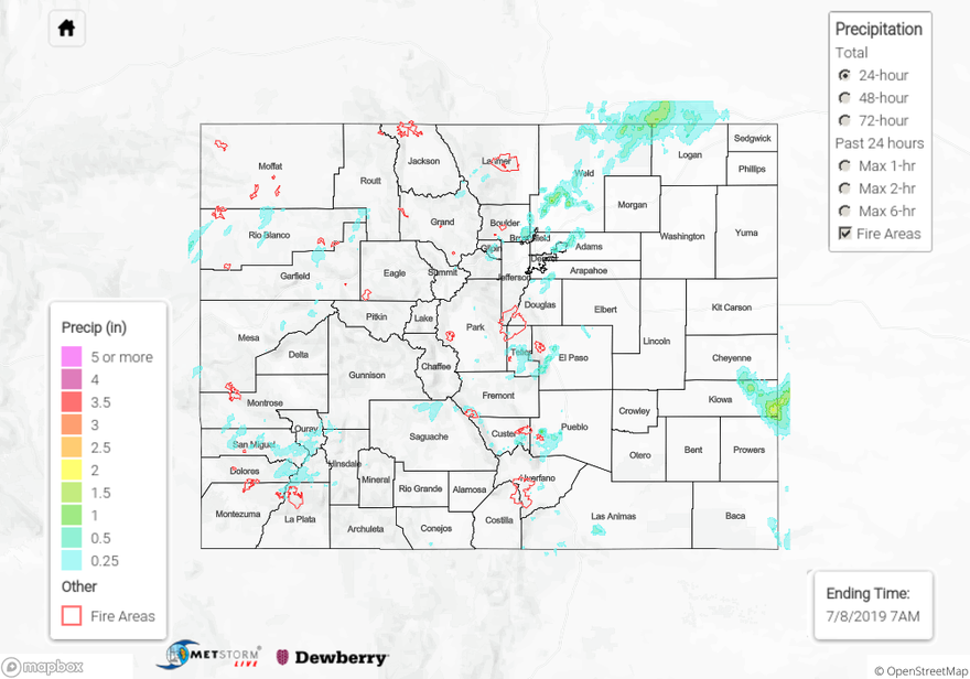
Similar pattern to Saturday across the state with an increase of moisture over western Colorado (northward), which allowed showers and weak thunderstorms back into the forecast across the western region. Passing shortwaves from the trough and around the high pressure helped kick off a little more widespread activity with the diurnal flow pattern. Storm motion was to the northeast, but back building allowed for some higher accumulations. Storms to the west produced strong gusts, plentiful lightning and spots of moderate rainfall totals for this time of year. Outflow gusts from storms were measured around 50 mph at various locations. There was a rainfall report of 0.78 inches of rain in Montrose with 0.64 inches reported in Durango. 24-hour totals just north of the 416 fire were just under 0.5 inches. Over Marvel, CO a CoCoRaHS station recorded 0.84 inches.

To the east, highest accumulations were over the northern Urban Corridor and Kiowa County with storms moving off the high terrains around 4PM. Storms had some decent low level moisture to work with over the adjacent plains, and with trailing storms, totals by radar were estimated as high as 1.5 inches. An Areal Flood advisory was issued over the area of this storm, but flooding was not reported as of this morning. Hail also accompanied the storms with reports of 0.75 inch diameter hail in Lafayette and Louisville. At 5:50PM MDT, a Flood Advisory was also issued for the Hayden Pass burn area. Radar estimated up to 0.35 inches of rain fell over the scar, but flooding was not reported. Lastly, an outflow boundary from convection in Kansas kicked off a thunderstorm over Kiowa County in the moisture rich environment around 1:30 AM. Radar estimates around 2 inches of rain fell with this storm.

No NWS Flood Warnings were issued for riverine flooding yesterday. However the Blue River below Dillon and Roaring Fork River in Pitkin County had Flood Advisories for Minor flooding of low lying areas next to the river, including pedestrian paths. To see the latest Flood Advisories, click the FTB and scroll down the riverine section.

Outside of Minor lowland flooding along the Roaring Fork River, flooding was not reported yesterday. To see estimated precipitation totals over your area on Sunday, scroll down to the State Precipitation Map below.

Click Here For Map Overview

The map below shows radar-estimated, rainfall gage-adjusted Quantitative Precipitation Estimates (QPE) across Colorado. The map is updated daily during the operational season (May 1 – Sep 30) by 11AM. The following six layers are currently available: 24-hour, 48-hour and 72-hour total precipitation, as well as maximum 1-hour, 2-hour and 6-hour precipitation over the past 24 hour period (to estimate where flash flooding may have occurred). The 24-hour, 48-hour and 72-hour total precipitation contain bias corrections that are not disaggregated into the hourly estimates, so there will likely be some differences. The accumulation ending time is 7AM of the date shown in the bottom right corner. Also shown optionally are vulnerable fire burn areas (post 2012), which are updated throughout the season to include new, vulnerable burn areas. The home button in the top left corner resets the map to the original zoom.

SPM 07-07-2019: Thunderstorms Over the Central High Country and Northeast Plains

Issue Date: Sunday, July 7, 2019
Issue Time: 10:45AM MDT

Summary:

Brief afternoon thunderstorms formed over the Continental Divide yesterday as a shortwave passed over Colorado.  Additional severe thunderstorms clipped the far northeast corner of the state along a stationary boundary late last night. Weak steering winds over the northern half of the state and high country prevented most storms from moving to the east off of the Divide.  Moisture returned to the western half of the state after a mostly dry week, with maximum relative humidity measuring up to 95% over the San Juan Mountains and San Luis Valley.  Precipitation remained light in most areas, with CoCoRaHS stations measuring between a trace and 0.2 inches.  The far northeast corner measured the most rain for the day, with 1 inch measured in Sedgwick County.  Downsloping winds off of the Southeast Mountains weakened moisture advection over the Raton Ridge, Southeast Plains, and Palmer Ridge, thus preventing rainfall over most of the area.  Radar derived rain up to 0.5 inches over the Raton Ridge but CoCoRaHS stations only measured 0.27 inches.

Gages remain in action stage along the Arkansas River near La Junta and Avondale, the Blue River below Dillon, the Roaring Fork River near Aspen, and the Rio Grande River at Alamosa.  Flows along these rivers remain high due to upstream dam releases.  No flooding was reported yesterday.

For a look at precipitation estimates in your area, please see the State Precipitation Map below.

Click Here For Map Overview

The map below shows radar-estimated, rainfall gage-adjusted Quantitative Precipitation Estimates (QPE) across Colorado. The map is updated daily during the operational season (May 1 – Sep 30) by 11AM. The following six layers are currently available: 24-hour, 48-hour and 72-hour total precipitation, as well as maximum 1-hour, 2-hour and 6-hour precipitation over the past 24 hour period (to estimate where flash flooding may have occurred). The 24-hour, 48-hour and 72-hour total precipitation contain bias corrections that are not disaggregated into the hourly estimates, so there will likely be some differences. The accumulation ending time is 7AM of the date shown in the bottom right corner. Also shown optionally are vulnerable fire burn areas (post 2012), which are updated throughout the season to include new, vulnerable burn areas. The home button in the top left corner resets the map to the original zoom.

SPM 07-06-2019: Severe Thunderstorms and Large Hail East of the Foothills

Issue Date: Saturday, July 6, 2019
Issue Time: 9:30 AM MDT

Summary:

Severe thunderstorms were reported over the Urban Corridor, eastern plains, and Palmer Ridge yesterday as a shortwave passed over the state. Moisture levels remained high throughout the day, as a surface low pulled in moisture rich air from the Great Plains. Upslope flow over the Urban Corridor and Palmer Ridge caused storms to pick up and rapidly intensify around 3PM. Upper level steering winds were very weak, which allowed thunderstorms to linger over areas for quite some time, producing hail and heavy rain. Overnight a low level jet over the eastern plains provided dynamic forcing to maintain severe storms into the early morning. Rain gages from the UDFCD Alert network reported 1.79 inches in 2 hours near Longmont, and 1.06 inches in 2 hours near Boulder Municipal Airport. Large hail was reported the NWS throughout the Urban Corridor, with notable reports of 2.5 inch diameter hail in El Paso County near Black Forest and in Boulder County near Lafayette. Heavy rain was also reported to the NWS, with 0.61 inches in 15 minutes reported near Firestone in Weld County, and 2.36 inches in 90 minutes over Cheyenne County! Radar derived estimates up to 3.5 inches over Cheyenne County, and up to 2.5 inches in El Paso County.

No flash flooding was reported yesterday. The river gage on the Arkansas River near Avondale retreated to Action stage around 9PM last night. The gage along the Roaring Fork River near Aspen rose to Action stage early this morning due to snow melt throughout the week.

For a look at precipitation estimates in your area, please see the State Precipitation Map below.

Click Here For Map Overview

The map below shows radar-estimated, rainfall gage-adjusted Quantitative Precipitation Estimates (QPE) across Colorado. The map is updated daily during the operational season (May 1 – Sep 30) by 11AM. The following six layers are currently available: 24-hour, 48-hour and 72-hour total precipitation, as well as maximum 1-hour, 2-hour and 6-hour precipitation over the past 24 hour period (to estimate where flash flooding may have occurred). The 24-hour, 48-hour and 72-hour total precipitation contain bias corrections that are not disaggregated into the hourly estimates, so there will likely be some differences. The accumulation ending time is 7AM of the date shown in the bottom right corner. Also shown optionally are vulnerable fire burn areas (post 2012), which are updated throughout the season to include new, vulnerable burn areas. The home button in the top left corner resets the map to the original zoom.

SPM 07-05-2019: Heavy Rain, Hail and Severe Thunderstorms

Issue Date: Friday, July 5th, 2019
Issue Time: 11:00 AM MDT

Summary:

High levels of surface moisture and a passing shortwave produced heavy rainfall and hail over the Urban Corridor and Northeast Plains.  Slow southerly steering winds combined with deep convection produced severe storms over the Urban Corridor, with reports to NWS of 1.5 inch diameter hail over Monument, and 2 inch diameter hail near Parker.  CoCoRaHS stations along the Urban Corridor reported rain between 0.3 and 0.7 inches, with isolated reports of up to 1.03 inches in Arapahoe, Denver, and Adams Counties.  Early evening storms that initiated over the Cheyenne Ridge produced up to 1.13 inches in Logan County.  Radar derived estimates over the Northeast Plains produced up to 1.5 inches in southeastern Morgan and Northern Washington Counties.  A few isolated storms over the Palmer Ridge and Southeast Plains also showed radar derived estimates of up to 0.5 inches.

Minor flood stage was maintained throughout the day yesterday along the Arkansas River near Avondale.  Rivers remain swollen in the high country due to snowmelt and dam releases.  For more information on river levels, please visit today’s FTB.

To see estimated precipitation totals over your neighborhood yesterday, scroll down to the State Precipitation Map below.

Click Here For Map Overview

The map below shows radar-estimated, rainfall gage-adjusted Quantitative Precipitation Estimates (QPE) across Colorado. The map is updated daily during the operational season (May 1 – Sep 30) by 11AM. The following six layers are currently available: 24-hour, 48-hour and 72-hour total precipitation, as well as maximum 1-hour, 2-hour and 6-hour precipitation over the past 24 hour period (to estimate where flash flooding may have occurred). The 24-hour, 48-hour and 72-hour total precipitation contain bias corrections that are not disaggregated into the hourly estimates, so there will likely be some differences. The accumulation ending time is 7AM of the date shown in the bottom right corner. Also shown optionally are vulnerable fire burn areas (post 2012), which are updated throughout the season to include new, vulnerable burn areas. The home button in the top left corner resets the map to the original zoom.