SPM 07-12-2019: Widespread Afternoon Thunderstorms over the High Country and Southeast Plains

Issue date: Friday, July 12, 2019
Issue Time: 9:50AM MDT

Summary:

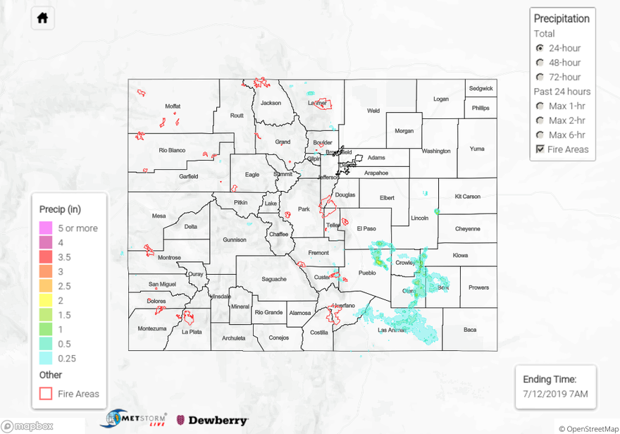
Midlevel moisture returned to the state yesterday as moisture was advected in on the backside of the high pressure system centered over the area.  A midlevel vorticity maximum formed a surface low in south-central Colorado yesterday around 1PM, sparking thunderstorms over the high country and Southeast Plains.  Weak northwesterly flow pushed the storms off of the Southeast Mountains and over the surrounding plains early last night.  Outflow boundaries from two storms combined over the Pueblo area to create a short-lived MCS that traveled to the southeast.  Weak upper level dynamics prevented the MCS from traveling to the southeast border, but moderate to heavy rainfall was reported throughout the Southeast Plains.  Radar derived rainfall up to 2 inches to the north of Avondale.  Surface reports from CoCoRaHS measured 0.48 inches near La Junta in Otero County, and 0.84 inches near Villegreen in Las Animas County.

Upslope flow along the Front Range was aided by the passage of a shortwave through Wyoming last night, producing rain over the foothills and Urban Corridor around sunset.  A RAWS surface observation near Redfeather Lakes in Larimer County reported 0.72 inches of rain over a two hour period around 6PM.  Other reports throughout the high country show marginal accumulations up to 0.1 inches.

For a look at precipitation in your area, please check out our State Precipitation Map below.

Click Here For Map Overview

The map below shows radar-estimated, rainfall gage-adjusted Quantitative Precipitation Estimates (QPE) across Colorado. The map is updated daily during the operational season (May 1 – Sep 30) by 11AM. The following six layers are currently available: 24-hour, 48-hour and 72-hour total precipitation, as well as maximum 1-hour, 2-hour and 6-hour precipitation over the past 24 hour period (to estimate where flash flooding may have occurred). The 24-hour, 48-hour and 72-hour total precipitation contain bias corrections that are not disaggregated into the hourly estimates, so there will likely be some differences. The accumulation ending time is 7AM of the date shown in the bottom right corner. Also shown optionally are vulnerable fire burn areas (post 2012), which are updated throughout the season to include new, vulnerable burn areas. The home button in the top left corner resets the map to the original zoom.

SPM 07-11-2019: Weak Thunderstorms over the High Country

Issue date: Thursday, July 11, 2019
Issue Time: 9:45 AM MDT

Summary:

Isolated weak thunderstorms formed over the San Juan Mountains and Central Mountains yesterday afternoon as a vorticity maximum formed over the area.  Slow upper level winds and large scale subsidence underneath the high pressure ridge prevented the storms from moving over the eastern plains.  Radar derived rainfall of up to 0.25 inches over the regions above.  CWOP stations near Fairplay in Park County and Trinidad in Las Animas County measured 0.13 and 0.05 inches respectively.  Many surface stations underneath areas of radar measured rainfall didn’t report rain, meaning that dry air underneath the storm base likely evaporated the precipitation prior to it reaching the surface.  Passage of the cold front over the eastern plains, kept high temperatures in the upper 80°Fs yesterday, but clear skies and advection of hot, dry air from the west southwest allowed highs to reach 98°F over the Grand Valley.

The AHPS gage on the Arkansas River near La Junta retreated below Action stage rapidly by noon yesterday morning.  The gage on the Rio Grande River near Alamosa remains at Action stage.  There were no reports of flooding yesterday.

For a look at precipitation in your area, please check out our State Precipitation Map below.

Click Here For Map Overview

The map below shows radar-estimated, rainfall gage-adjusted Quantitative Precipitation Estimates (QPE) across Colorado. The map is updated daily during the operational season (May 1 – Sep 30) by 11AM. The following six layers are currently available: 24-hour, 48-hour and 72-hour total precipitation, as well as maximum 1-hour, 2-hour and 6-hour precipitation over the past 24 hour period (to estimate where flash flooding may have occurred). The 24-hour, 48-hour and 72-hour total precipitation contain bias corrections that are not disaggregated into the hourly estimates, so there will likely be some differences. The accumulation ending time is 7AM of the date shown in the bottom right corner. Also shown optionally are vulnerable fire burn areas (post 2012), which are updated throughout the season to include new, vulnerable burn areas. The home button in the top left corner resets the map to the original zoom.

SPM 07-10-2019: Isolated Thunderstorm Over the Northeast Plains, Sunny and Dry Statewide

Issue Date: Wednesday, July 10, 2019
Issue Time: 10AM MDT

Summary:

Things really dried out yesterday as high pressure set in over the area.  West of the Continental Divide maximum relative humidity stayed below 50% over most areas. High temperatures approached 100°F in the Arkansas River Valley over the Southeast Plains, with temperatures in the low 90°Fs over most of the eastern plains.  Highs were measured in the 60°Fs and 70°Fs over the high country, with a high of 94°Fs near Grand Junction.  An isolated thunderstorm passed over the far northeast corner of the state around 11PM yesterday as a cold front made its way south over the area.  A CoCoRaHS station near Julesburg in Sedgwick County measured 0.5 inches of rain.  Two additional CoCoRaHS stations picked up marginal rain yesterday in Teller and Chaffee Counties, measuring 0.01 and 0.02 inches respectively.

Flooding was not reported on Tuesday.  The AHPS gage bellow Dillon retreated below Action stage mid-morning yesterday and the Flood Advisory for the Roaring Fork River near Aspen was cancelled at 11:30AM as waters retreated below bankfull.  The gages on the Arkansas River near La Junta and the Rio Grande near Alamosa remain at Action State due to dam releases.

For rainfall estimates in your area, check out our State Precipitation Map below.

Click Here For Map Overview

The map below shows radar-estimated, rainfall gage-adjusted Quantitative Precipitation Estimates (QPE) across Colorado. The map is updated daily during the operational season (May 1 – Sep 30) by 11AM. The following six layers are currently available: 24-hour, 48-hour and 72-hour total precipitation, as well as maximum 1-hour, 2-hour and 6-hour precipitation over the past 24 hour period (to estimate where flash flooding may have occurred). The 24-hour, 48-hour and 72-hour total precipitation contain bias corrections that are not disaggregated into the hourly estimates, so there will likely be some differences. The accumulation ending time is 7AM of the date shown in the bottom right corner. Also shown optionally are vulnerable fire burn areas (post 2012), which are updated throughout the season to include new, vulnerable burn areas. The home button in the top left corner resets the map to the original zoom.

SPM 07-09-2019: Severe Thunderstorms Over the Eastern Plains and Light Rain Over the High Country

Issue Date: Tuesday, July 9, 2019
Issue Time: 10AM MDT

Summary:

Upper level forcing was favorable for severe thunderstorms over the eastern plains.  A shortwave passed over the northern edge of the state yesterday afternoon, which aided warm, moist air in the production of hail and heavy rain.  Directional wind shear over the eastern plains allowed for the generation of supercells, which consequently caused the NWS to issue two tornado warnings, one over Yuma County and the other over the boundary of Kit Carson and Cheyenne Country.  Flash flooding was reported to the NWS at 8PM last night in Cheyenne County near Wells with reports of flooding over roadways.  Areal flood warnings were also issued by the NWS over Washington County at 7PM, with radar indicating 3 to 6 inches of rain since noon.  Powerful outflow boundaries off of a storm generated over the Palmer Ridge around noon produced a MCS that traveled slowly over the eastern plains, producing widespread moderate rainfall.  Radar estimated 1.5 to 2 inches over rain over Kit Carson, Cheyenne, and Washington Counties.

Upslope flow over the high country allowed for afternoon showers, but accumulation remained limited as dry air entered the state from the west and southwest throughout the day.  Rain was greatest over the I-70 corridor, with reports from CoCoRaHS of up to 0.3 inches spanning from Clear Creek to eastern Garfield County.  Heavy rainfall of 0.71 inches was reported to the NWS near Fruitvale in Mesa County at 3PM.  Storms made their way off of the Front Range and Southeast Mountains by 3PM, but high cloud bases limited accumulation in most areas along the foothills to 0.1 inches, with isolated CoCoRaHS reports of 0.48 inches in El Paso County.

To see estimated precipitation totals over your area on Monday, scroll down to the State Precipitation Map below.

Click Here For Map Overview

The map below shows radar-estimated, rainfall gage-adjusted Quantitative Precipitation Estimates (QPE) across Colorado. The map is updated daily during the operational season (May 1 – Sep 30) by 11AM. The following six layers are currently available: 24-hour, 48-hour and 72-hour total precipitation, as well as maximum 1-hour, 2-hour and 6-hour precipitation over the past 24 hour period (to estimate where flash flooding may have occurred). The 24-hour, 48-hour and 72-hour total precipitation contain bias corrections that are not disaggregated into the hourly estimates, so there will likely be some differences. The accumulation ending time is 7AM of the date shown in the bottom right corner. Also shown optionally are vulnerable fire burn areas (post 2012), which are updated throughout the season to include new, vulnerable burn areas. The home button in the top left corner resets the map to the original zoom.