Issue Date: Tuesday, July 9, 2019
Issue Time: 10AM MDT
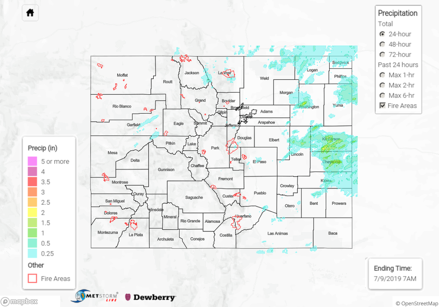
Summary:
Upper level forcing was favorable for severe thunderstorms over the eastern plains. A shortwave passed over the northern edge of the state yesterday afternoon, which aided warm, moist air in the production of hail and heavy rain. Directional wind shear over the eastern plains allowed for the generation of supercells, which consequently caused the NWS to issue two tornado warnings, one over Yuma County and the other over the boundary of Kit Carson and Cheyenne Country. Flash flooding was reported to the NWS at 8PM last night in Cheyenne County near Wells with reports of flooding over roadways. Areal flood warnings were also issued by the NWS over Washington County at 7PM, with radar indicating 3 to 6 inches of rain since noon. Powerful outflow boundaries off of a storm generated over the Palmer Ridge around noon produced a MCS that traveled slowly over the eastern plains, producing widespread moderate rainfall. Radar estimated 1.5 to 2 inches over rain over Kit Carson, Cheyenne, and Washington Counties.
Upslope flow over the high country allowed for afternoon showers, but accumulation remained limited as dry air entered the state from the west and southwest throughout the day. Rain was greatest over the I-70 corridor, with reports from CoCoRaHS of up to 0.3 inches spanning from Clear Creek to eastern Garfield County. Heavy rainfall of 0.71 inches was reported to the NWS near Fruitvale in Mesa County at 3PM. Storms made their way off of the Front Range and Southeast Mountains by 3PM, but high cloud bases limited accumulation in most areas along the foothills to 0.1 inches, with isolated CoCoRaHS reports of 0.48 inches in El Paso County.
To see estimated precipitation totals over your area on Monday, scroll down to the State Precipitation Map below.
Click Here For Map Overview