SPM 08-09-2019: Heavy Rainfall over the Palmer Ridge Causes Flooding Issues

Issue Date: Friday, August 9th, 2019
Issue Time: 10:10AM MDT

Summary:

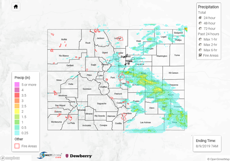
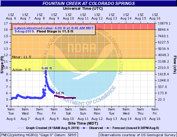
Storms began to initiate yesterday around 1PM. As storms moved into the moisture rich environment over the adjacent eastern plains, they dropped quite a bit of rainfall. They were moving fairly quickly, which kept totals from being too high. Therefore the higher totals you see over the Palmer Ridge are from a one or more storms passing over throughout the 24-hour period. Max 1-hour rainfall rates were still impressive though for how fast the storms were moving (1-1.5 inches). One storm over NE Huerfano County recorded 2.5 inches. There were several ALERT gages over Douglas County that produced over an inch per hour as well with the highest gage near Perry Park at 1.7 inches (from two storms). A Flash Flood was reported east of I-25 near the Air Force Academy where 6 or more inches of rain were flowing over the roadway. A nearby spotter report 1.5 inches just south of the report. The WWTP station at the USAF recorded 2.68 inches for the 24-hour period! Near Manitou Springs, another USGS gage recorded 2.11 inches for the 24-hour period. Not surprisingly, this heavy rainfall caused Fountain Creek at Colorado Springs to spike into Action Stage (see below). There was even a brief touchdown of a tornado (source: spotter) near Meadow Lake Airport. Storms yesterday were producing some strong outflow boundaries, so the dust on the ground could very well have been associated with this feature rather than a tornado touchdown. NWS will do a survey in the next day or two to confirm the touchdown. Near Wetmore, 1.7 inches of rain was reported with street flooding and rocks on Highway 96. This will enhance the flood threat over the Junkins burn area this afternoon as soils are likely saturated, which would increase runoff and the potential for flash flooding.

Alamosa even saw some rainfall with trace amounts recorded in the interior of the valley. Along the edges near Del Norte, close to a half inch was recorded by two CoCoRaHS stations. Best rainfall over the higher terrains of western Colorado was near Powderhorn and Gunnison and then north near the Flat Tops. Radar indicates up to 0.5 inches fell near the higher elevations of Palisade. Meeker Airport recorded 0.26 inches for the day and Gypsum 0.34 inches. Flooding was not reported west of the Continental Divide due to faster steering winds and drier air mixing in from the southwest.

To see estimated precipitation totals over your neighborhood, scroll down the State Precipitation Map below.

Click Here For Map Overview

The map below shows radar-estimated, rainfall gage-adjusted Quantitative Precipitation Estimates (QPE) across Colorado. The map is updated daily during the operational season (May 1 – Sep 30) by 11AM. The following six layers are currently available: 24-hour, 48-hour and 72-hour total precipitation, as well as maximum 1-hour, 2-hour and 6-hour precipitation over the past 24 hour period (to estimate where flash flooding may have occurred). The 24-hour, 48-hour and 72-hour total precipitation contain bias corrections that are not disaggregated into the hourly estimates, so there will likely be some differences. The accumulation ending time is 7AM of the date shown in the bottom right corner. Also shown optionally are vulnerable fire burn areas (post 2012), which are updated throughout the season to include new, vulnerable burn areas. The home button in the top left corner resets the map to the original zoom.

SPM 08-08-2019: Widespread Severe Thunderstorms over the Eastern Plains

Issue Date: Thursday, August 8, 2019
Issue Time: 10:40AM MDT

Summary:

Another day of heavy rainfall and severe thunderstorms over the far eastern plains. The dryline set up farther to the southwest than originally forecast, which allowed for severe thunderstorms to form over the Southeast Plains. Most storms also initiated later than expected, but once a few storms were able to generate, gust fronts did the rest of the work spreading out storm coverage. There were a few isolated reports of hail over Cheyenne, Elbert, Kiowa Counties, with golf ball sized hail reported over Cheyenne Wells! Heavy rainfall of 1.53 inches was measured over a two hour period near Burlington in Kit Carson County, with an additional report of 2.2 inches near Stratton. The highest radar derived measurements for the day occurred in Kiowa and Washington Counties, measuring up to 3 inches in isolated areas. Surface reports from CoCoRaHS stations reported up to 2.24 inches of rain in Morgan County, giving the area the highest surface measurement of the day. A few brief storms over the Urban Corridor measured up to 0.47 inches at a UDFCD Alert gage at the Englewood Dam in Arapahoe County.

Back to the west storms lasted throughout the day, but lack of instability kept storms from producing brief periods of heavy rainfall. The San Juan Mountains had the highest accumulations for the day, with a CoCoRaHS station in northern La Plata County near the 416 burn area measuring up to 0.51 inches. However, no flooding was reported over the burn area. A RAWS station near Buckles in southern Conejos County reported up to 0.38 inches of rain over a 3 hour period. Surface reports throughout the high country indicated measurable precipitation, however most reports were of less than 0.11 inches over 24 hours. A Flash Flood warning was issued by the NWS over the Spring Creek burn area, however no flooding was reported.

For a look at precipitation over your area, please see the State Precipitation Map below.

Click Here For Map Overview

The map below shows radar-estimated, rainfall gage-adjusted Quantitative Precipitation Estimates (QPE) across Colorado. The map is updated daily during the operational season (May 1 – Sep 30) by 11AM. The following six layers are currently available: 24-hour, 48-hour and 72-hour total precipitation, as well as maximum 1-hour, 2-hour and 6-hour precipitation over the past 24 hour period (to estimate where flash flooding may have occurred). The 24-hour, 48-hour and 72-hour total precipitation contain bias corrections that are not disaggregated into the hourly estimates, so there will likely be some differences. The accumulation ending time is 7AM of the date shown in the bottom right corner. Also shown optionally are vulnerable fire burn areas (post 2012), which are updated throughout the season to include new, vulnerable burn areas. The home button in the top left corner resets the map to the original zoom.

SPM 08-07-2019: Severe Thunderstorms over the Far Eastern Plains

Issue Date: Wednesday, August 7, 2019
Issue Time: 10:50AM MDT

Summary:

A brief round of isolated severe thunderstorms moved south over the far eastern plains along a dryline late yesterday and early this morning.  Storms were very high based, creating isolated areas of heavy rainfall.  Hail up 0.7 inches in diameter was reported to have lasted for 10 minutes to the west of Kit Carson in Cheyenne County.  Radar derived up to 2 inches of rain over Kit Carson and eastern Lincoln Counties last night, however surface reports throughout the area are sparse, so estimates may have been contaminated by hail.  The highest surface report over the eastern plains yesterday was measured by a CoCoRaHS station in Kiowa County near Eads, at 0.73 inches.  Severe thunderstorms over Bent County prompted the issuance of an Areal Flood Advisory by the NWS at 8:45 PM, however no flooding was reported over the area.  Isolated storms over El Paso County produced 24-hour rainfall totals up to 0.39 inches near Colorado Springs.  Radar derived up to 0.5 inches of rain over the northern edge of the Spring Creek burn area, however a CoCoRaHS station measured only 0.12 inches, implying that the storms were likely high based as well.

Back to the west it stayed pretty dry over most areas, with the exception of the Southwest Slope and southern San Juan Mountains.  Pockets of moisture came into the area from the southwest, providing moderate 24-hour totals over Montezuma, La Plata and Archuleta Counties.  An isolated thunderstorm late yesterday afternoon produced between 0.4 and 0.77 inches of rain near Pagosa Springs over a two hour period. Trace amounts of rainfall were measured over the Grand Valley, Northwest Slope, Central Mountains and Northern Mountains.  An isolated thunderstorm produced wind gusts up to 45 mph near Craig in eastern Moffat County.  No flooding was reported yesterday.

For a look at precipitation over your area, please visit the State Precipitation Map below.

Click Here For Map Overview

The map below shows radar-estimated, rainfall gage-adjusted Quantitative Precipitation Estimates (QPE) across Colorado. The map is updated daily during the operational season (May 1 – Sep 30) by 11AM. The following six layers are currently available: 24-hour, 48-hour and 72-hour total precipitation, as well as maximum 1-hour, 2-hour and 6-hour precipitation over the past 24 hour period (to estimate where flash flooding may have occurred). The 24-hour, 48-hour and 72-hour total precipitation contain bias corrections that are not disaggregated into the hourly estimates, so there will likely be some differences. The accumulation ending time is 7AM of the date shown in the bottom right corner. Also shown optionally are vulnerable fire burn areas (post 2012), which are updated throughout the season to include new, vulnerable burn areas. The home button in the top left corner resets the map to the original zoom.

SPM 08-06-2019: Weak Thunderstorms/Showers over the High Terrains with Activity Spilling into the Adjacent Plains

Issue Date: Tuesday, August 6th, 2019
Issue Time: 9:15AM MDT

Summary:

A bit of a lull in heavy rain yesterday with some drying occurring at the low and mid-levels of the atmosphere. Moisture was effectively cutoff over western Colorado thanks to the westward movement of the high. However, some decent rainfall was still able to accumulate further to the south over the San Juan Mountains closer to the high. CoCoRaHS stations near Pagosa Springs recorded between 0.71 and 0.83 inches for the 24-hour period. Another station near Norwood, CO had 0.52 inches with quarter inch hail. Most other storms over western Colorado yesterday were high-based, so rainfall amounts were generally under 0.25 inches.

Back to the west, there were a few isolated showers over the Southeast Mountains and adjacent plains. Storm totals up to 0.8 inches were recorded over Pueblo County. There were also some thunderstorms over Weld County that moved in from the Cheyenne Ridge. No gages were in the area, but MetStorm estimated up to 1 inch fell over the area. The Fort Collins mesonet had two gages (4 miles apart) record just over 0.3 inches along Highway 14. As expected, there were no reports of flooding on Monday.

To see estimated precipitation totals over your neighborhood, scroll down the State Precipitation Map below.

Click Here For Map Overview

The map below shows radar-estimated, rainfall gage-adjusted Quantitative Precipitation Estimates (QPE) across Colorado. The map is updated daily during the operational season (May 1 – Sep 30) by 11AM. The following six layers are currently available: 24-hour, 48-hour and 72-hour total precipitation, as well as maximum 1-hour, 2-hour and 6-hour precipitation over the past 24 hour period (to estimate where flash flooding may have occurred). The 24-hour, 48-hour and 72-hour total precipitation contain bias corrections that are not disaggregated into the hourly estimates, so there will likely be some differences. The accumulation ending time is 7AM of the date shown in the bottom right corner. Also shown optionally are vulnerable fire burn areas (post 2012), which are updated throughout the season to include new, vulnerable burn areas. The home button in the top left corner resets the map to the original zoom.