SPM 08-22-2022: High Terrain Heavy Rain, Isolated Heavy Rain for Plains

Issue Date: Monday, August 22nd, 2022
Issue Time: 11:00 AM MDT

Summary:

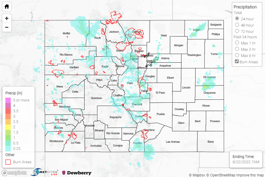
Sunday featured a similar pattern and similar weather compared to Saturday, with the heaviest rain falling from the Grand Valley eastward into the Urban Corridor, particularly to the south and east of Denver. Showers and storms developed by early afternoon over the high terrain and moved off into the foothills later in the day. Development was aided by an upper-level trough that pushed into northwest Colorado and provided synoptic lift, while faster flow associated with this trough yielded slightly faster storm motions and therefore a slightly lower flash flooding threat compared to previous days.

Out west in the Grand Valley, QPE data suggests localized amounts up to 1.50”. A Flash Flood Warning was issued for the Pine Gulch burn scar, while three other Flood Advisories were issued across Mesa County near Grand Junction; no flooding was reported in any of these locations. Rain gauge coverage is sparse, but an automated station northwest of Grand Junction measured 0.67”.

Moving eastward across the Central/Northern Mountains and into the Front Range, QPE data suggests more widespread totals approaching and exceeding 1.50”. A Flash Flood Warning was issued for the Grizzly Creek burn scar, while Flood Advisories were issued for both the East Troublesome and Cameron Peak burn scars; thankfully, no flooding reports were received. Notable rainfall reports include a CoCoRaHS observation of 1.15” northwest of Kremmling, and an automated station observation of 0.70” west of Estes Park.

Across the Urban Corridor, a line of convection along and east of I-25 produced a corridor of heavy rainfall from Greeley south to Aurora, with QPE data suggesting amounts up to 2” near Aurora. This rainfall prompted a Flood Advisory for portions of the Denver metro, with Denver Airport recording 1.14”. This total broke the daily rainfall record for August 21st and was also the first day in almost a year and a half that DIA measured more than 1” of precipitation! Other notable rainfall totals from automated stations include 1.26” and 0.83” near Aurora and Greeley, respectively.

Farther south across the San Juans and Southeast Mountains, QPE data suggests amounts of 0.50-1.00”. Out east across the Plains, isolated storms produced locally heavy rainfall across portions of Logan, Kit Carson, and Cheyenne Counties, where QPE data suggests amounts up to 2”.

If you observe flooding in your area, remember to use the “Report a Flood” page to make any flood reports when you can safely do so. For precipitation estimates in our area, check out the map below.

Click Here For Map Overview

The map below shows radar-estimated, rainfall gage-adjusted Quantitative Precipitation Estimates (QPE) across Colorado. The map is updated daily during the operational season (May 1 – Sep 30) by 11AM. The following six layers are currently available: 24-hour, 48-hour and 72-hour total precipitation, as well as maximum 1-hour, 2-hour and 6-hour precipitation over the past 24 hour period (to estimate where flash flooding may have occurred). The accumulation ending time is 7AM of the date shown in the bottom right corner. Also shown optionally are vulnerable fire burn areas (post 2012), which are updated throughout the season to include new, vulnerable burn areas. The home button in the top left corner resets the map to the original zoom.

SPM 08-21-2022: Heavy Rain for Central/Northern Mountains, Front Range

Issue Date: Sunday, August 21st, 2022
Issue Time: 11:45 AM MDT

Summary:

An upper-level closed low to our west over Utah, associated speed max, and residual monsoonal moisture helped to spark showers and thunderstorms over the state by mid-afternoon on Saturday. Again, precipitation coverage was mainly limited to the higher elevations of the mountains and western slope, with the heaviest rain falling over the Central/Northern Mountains and Front Range.

Across the western slope and Central Mountains, Flash Flood Warnings and Flood Advisories were issued for portions of San Miguel, Fremont, Mesa, Garfield, and Pitkin Counties, including for portions of the Hayden Pass burn scar (2016 fire); no flooding was reported in any of these locations. QPE data suggests localized amounts up to 2”, with CoCoRaHS reports of 1.22” near Collbran and 0.89” near Glenwood Springs, while 1.06” was recorded by an automated gauge near Glenwood Springs.

Farther north and east across the Northern Mountains/Front Range and into the Urban Corridor, a Flash Flood Warning and Flood Advisory were issued for the East Troublesome and Cameron Peak burn scars, respectively, although no flooding was reported. A Flood Advisory was also issued for portions of the I-25 corridor between Denver and Fort Collins, with no flooding reported. A storm in central Jefferson County prompted both a Flood Advisory and Severe Thunderstorm Warning, with 1.25” hail reported as well as hail accumulating up to 3” deep. QPE data suggests up to 2.5” of rain fell in some locations, while notable rain gauge observations include:

• 1.82” near Boulder
• 1.80” near Aspen Park
• 1.33” near Superior
• 1.15” near Evergreen
• 1.07” near Hot Sulphur Springs

Across the Southeast Mountains and into the Raton Ridge, lighter amounts up to 1.25” were observed, per QPE data; rain gauge observations in the vicinity include 1.09” and 0.63”, both near Trinidad.

If you observe flooding in your area, remember to use the “Report a Flood” page to make any flood reports when you can safely do so. For precipitation estimates in our area, check out the map below.

Click Here For Map Overview

The map below shows radar-estimated, rainfall gage-adjusted Quantitative Precipitation Estimates (QPE) across Colorado. The map is updated daily during the operational season (May 1 – Sep 30) by 11AM. The following six layers are currently available: 24-hour, 48-hour and 72-hour total precipitation, as well as maximum 1-hour, 2-hour and 6-hour precipitation over the past 24 hour period (to estimate where flash flooding may have occurred). The accumulation ending time is 7AM of the date shown in the bottom right corner. Also shown optionally are vulnerable fire burn areas (post 2012), which are updated throughout the season to include new, vulnerable burn areas. The home button in the top left corner resets the map to the original zoom.

SPM 08-20-2022: Heavy Rain for Grand Valley

Issue Date: Saturday, August 20th, 2022
Issue Time: 11:20 AM MDT

Summary:

Monsoonal moisture was on the uptick across the state on Friday as a shortwave trough approached the region. Showers and storms developed over the high terrain by early afternoon, with the heaviest rain falling over and around the Grand Valley and Central Mountains.

Numerous Flash Flood Warnings and Flood Advisories were issued across the western slope and mountains, including for portions of Rio Blanco, Garfield, Mesa, Delta, Gunnison, Montrose, and San Miguel Counties. Rainfall totals in this region were impressive, with QPE data suggesting up to 2.5”. Gauge observations lend credence to these estimated totals; CoCoRaHS reports include 1.89” near Cedaredge and 1.45” near Whitewater, while an automated gauge measured 1.58” near Palisade. A debris flow/mudslide was reported over County Road 3 near Marble across northern Gunnison County.

Farther east across the Front Range and Urban Corridor, Flash Flood Warnings were issued for portions of the Calwood burn scar and Colorado Springs. QPE data suggest up to 1” of rain fell, with a CoCoRaHS report of 0.99” near Colorado Springs and an automated gauge reporting 0.94” northwest of Golden. No flooding was reported. QPE also suggests amounts of up to 1” across portions of the Palmer Ridge.

If you observe flooding in your area, remember to use the “Report a Flood” page to make any flood reports when you can safely do so. For precipitation estimates in our area, check out the map below.

Click Here For Map Overview

The map below shows radar-estimated, rainfall gage-adjusted Quantitative Precipitation Estimates (QPE) across Colorado. The map is updated daily during the operational season (May 1 – Sep 30) by 11AM. The following six layers are currently available: 24-hour, 48-hour and 72-hour total precipitation, as well as maximum 1-hour, 2-hour and 6-hour precipitation over the past 24 hour period (to estimate where flash flooding may have occurred). The accumulation ending time is 7AM of the date shown in the bottom right corner. Also shown optionally are vulnerable fire burn areas (post 2012), which are updated throughout the season to include new, vulnerable burn areas. The home button in the top left corner resets the map to the original zoom.

SPM 08-19-2022: Calm and Dry

Issue Date: Friday, August 19th, 2022
Issue Time: 9:25 MDT

Summary:

Thursday was quite a dry day across the state, with most of Colorado receiving no rainfall. The Southwest Slope and a few locations across the Front Range were the only areas to receive any precipitation. In the southwest, observations were mostly under 0.1”, but a few higher observations include 0.78” near the Utah border, 0.41” in Pagosa Springs and 0.27” near Cortez. A flood advisory was issued in La Plata county from about 3:00 – 5:00 PM, but no flooding was reported.

As mentioned above, most areas along the Front Range and Urban Corridor saw very little to no rainfall. There were a few observations, in Fort Collins and Dumont, that noted up to 0.12” at their locations, but most other scattered reports came in under 0.05”.

No flooding was reported yesterday. If you observe flooding in your area, remember to use the “Report a Flood” page to make any flood reports when you can safely do so. For precipitation estimates in our area, check out the map below.

Click Here For Map Overview

The map below shows radar-estimated, rainfall gage-adjusted Quantitative Precipitation Estimates (QPE) across Colorado. The map is updated daily during the operational season (May 1 – Sep 30) by 11AM. The following six layers are currently available: 24-hour, 48-hour and 72-hour total precipitation, as well as maximum 1-hour, 2-hour and 6-hour precipitation over the past 24 hour period (to estimate where flash flooding may have occurred). The accumulation ending time is 7AM of the date shown in the bottom right corner. Also shown optionally are vulnerable fire burn areas (post 2012), which are updated throughout the season to include new, vulnerable burn areas. The home button in the top left corner resets the map to the original zoom.