Issue Date: Sunday, August 21st, 2022
Issue Time: 11:45 AM MDT
Summary:
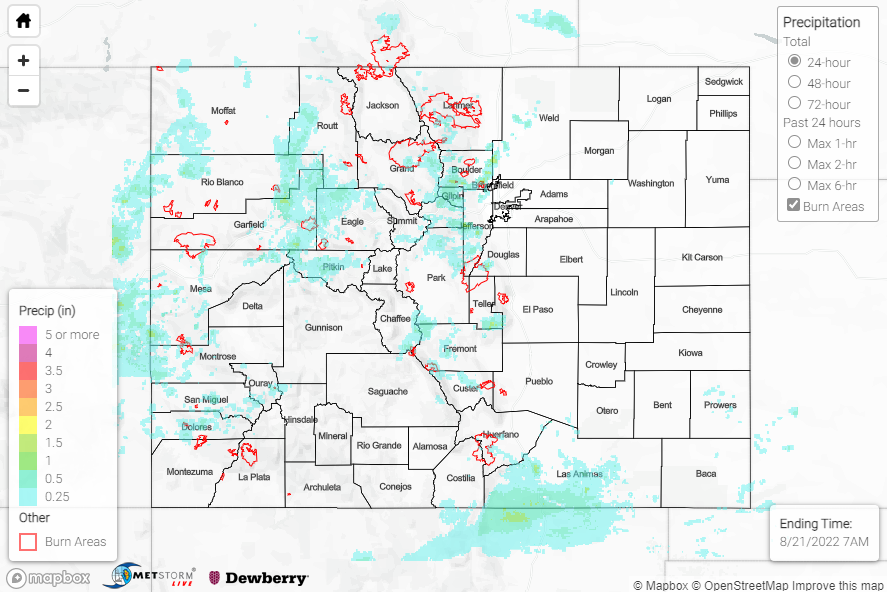
An upper-level closed low to our west over Utah, associated speed max, and residual monsoonal moisture helped to spark showers and thunderstorms over the state by mid-afternoon on Saturday. Again, precipitation coverage was mainly limited to the higher elevations of the mountains and western slope, with the heaviest rain falling over the Central/Northern Mountains and Front Range.
Across the western slope and Central Mountains, Flash Flood Warnings and Flood Advisories were issued for portions of San Miguel, Fremont, Mesa, Garfield, and Pitkin Counties, including for portions of the Hayden Pass burn scar (2016 fire); no flooding was reported in any of these locations. QPE data suggests localized amounts up to 2”, with CoCoRaHS reports of 1.22” near Collbran and 0.89” near Glenwood Springs, while 1.06” was recorded by an automated gauge near Glenwood Springs.
Farther north and east across the Northern Mountains/Front Range and into the Urban Corridor, a Flash Flood Warning and Flood Advisory were issued for the East Troublesome and Cameron Peak burn scars, respectively, although no flooding was reported. A Flood Advisory was also issued for portions of the I-25 corridor between Denver and Fort Collins, with no flooding reported. A storm in central Jefferson County prompted both a Flood Advisory and Severe Thunderstorm Warning, with 1.25” hail reported as well as hail accumulating up to 3” deep. QPE data suggests up to 2.5” of rain fell in some locations, while notable rain gauge observations include:
• 1.82” near Boulder
• 1.80” near Aspen Park
• 1.33” near Superior
• 1.15” near Evergreen
• 1.07” near Hot Sulphur Springs
Across the Southeast Mountains and into the Raton Ridge, lighter amounts up to 1.25” were observed, per QPE data; rain gauge observations in the vicinity include 1.09” and 0.63”, both near Trinidad.
If you observe flooding in your area, remember to use the “Report a Flood” page to make any flood reports when you can safely do so. For precipitation estimates in our area, check out the map below.
