SPM 08-26-2022: Continued Monsoonal Rainfall for Western Colorado

Issue Date: Friday, August 26th, 2022
Issue Time: 10:30 AM MDT

Summary:

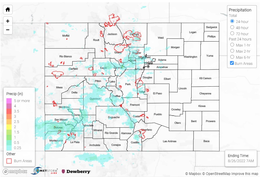
Precipitation across Colorado was largely constrained to the western half of the state yesterday. The Southwest Slope to Central Mountains continued to benefit from monsoonal moisture circulating the high-pressure system centered over the Colorado-New Mexico border. Early morning cloud coverage over much of the region limited some heavy rainfall potential, though cloud-free areas, especially in the higher terrain, saw more intense convection. Gusty outflows from afternoon storms also resulted in non-thunderstorm wind gusts of 46 and 45 mph in Craig and Montrose, respectively. For the Northern Mountains, a shortwave dipping south into the state from Wyoming helped provide the necessary ingredients for showers and thunderstorms there, spilling onto the Front Range and Urban Corridor as the day progressed. The Eastern Plains remained largely dry yesterday.

Only a few flood advisories and a flash flood warning for Larimer county were issued yesterday, which included portions of the Cameron Peak burn scar. Several automated gages reported up to 0.28-0.31 inches over the scar, though thankfully no flooding was reported so far.

As of this morning, CDOT has reported debris on US550 in two locations from Ouray to Silverton, both causing brief closures. Gauge observations nearby are sparse, but QPE from MetStorm live puts up to 0.50 inches over the area and a MesoWest gauge west of Ouray reported 0.87 inches yesterday.

Some other notable high precipitation totals (in inches) across Colorado include:

  • 1.14 in Crestone
  • 0.91 near Hesperus
  • 0.82 at Long Hollow Reservoir (and between 0.40- 0.70 elsewhere in Montezuma and La Plata Counties on the Southwest Slope)
  • 0.77 in Vail
  • 0.73 in Divide, along with brief graupel
  • 0.61 near Pagosa Springs
  • 0.59 in Nederland

Precipitation totals were more modest along the Front Range and western edge of the Urban Corridor, but up to 0.51 was reported from a MHFD gauge near Hidden Lake northwest of Boulder.

Some other important news – beginning yesterday, Denver’s radar went down for service, lasting approximately the next week. See the tweet below from the Boulder WFO explaining the service upgrade and radar coverage without Denver online. While the Denver radar has greater coverage from adjacent stations when down, especially compared to Grand Junction and Pueblo, QPE in the region will still likely be underestimated during the week of the outage.

If you observe flooding in your area, remember to use the “Report a Flood” page to make any flood reports when you can safely do so. For precipitation estimates in our area, check out the map below.

Click Here For Map Overview

The map below shows radar-estimated, rainfall gage-adjusted Quantitative Precipitation Estimates (QPE) across Colorado. The map is updated daily during the operational season (May 1 – Sep 30) by 11AM. The following six layers are currently available: 24-hour, 48-hour and 72-hour total precipitation, as well as maximum 1-hour, 2-hour and 6-hour precipitation over the past 24 hour period (to estimate where flash flooding may have occurred). The accumulation ending time is 7AM of the date shown in the bottom right corner. Also shown optionally are vulnerable fire burn areas (post 2012), which are updated throughout the season to include new, vulnerable burn areas. The home button in the top left corner resets the map to the original zoom.

SPM 08-25-2022: Heavy Rain for Portions of San Juans, Southwest Slope

Wednesday was a repeat of Tuesday, with precipitation confined to the highest terrain and in many of the same locations. Storms were of the pulse variety, quickly forming and then collapsing with limited potential for severe weather.

Rainfall was once again observed at high elevations from the Northern Mountains southward into the San Juans and Southeast Mountains, while the heaviest rainfall appears to have fallen across portions of the San Juans and into the western slope; amounts of 0.50-1.25” are indicated by QPE data. Flood Advisories were issued for both the Cameron Peak and East Troublesome burn scars, but no flooding was reported. Near the southern Northwest Slope/northern Grand Valley over the Roan Plateau, Flood Advisories were issued for portions of the Pine Gulch burn scar in Garfield County; no flooding was reported. Lastly, storms over the Southwest Slope near Cortez in Montezuma County prompted another Flood Advisory, with no flooding reported.

Notable rainfall totals from the southwest quadrant of the state include 1.12” near Durango, 1.08” near Del Norte, 1.06” near Cortez, 0.93” near La Garita, and 0.90” near Lewis. This total near Lewis was reported as falling in 30 minutes, which has an estimated ARI of about 14 years! Rain gauge observations across the rest of the state were light, being generally 0.25” or less.

If you observe flooding in your area, remember to use the “Report a Flood” page to make any flood reports when you can safely do so. For precipitation estimates in our area, check out the map below.

Click Here For Map Overview

The map below shows radar-estimated, rainfall gage-adjusted Quantitative Precipitation Estimates (QPE) across Colorado. The map is updated daily during the operational season (May 1 – Sep 30) by 11AM. The following six layers are currently available: 24-hour, 48-hour and 72-hour total precipitation, as well as maximum 1-hour, 2-hour and 6-hour precipitation over the past 24 hour period (to estimate where flash flooding may have occurred). The accumulation ending time is 7AM of the date shown in the bottom right corner. Also shown optionally are vulnerable fire burn areas (post 2012), which are updated throughout the season to include new, vulnerable burn areas. The home button in the top left corner resets the map to the original zoom.

SPM 08-24-2022: Rain Limited to Mountains

Issue Date: Wednesday, August 24th, 2022
Issue Time: 10:50 AM MDT

Summary:

Tuesday continued the trend of decreasing precipitation coverage across the state, as showers and storms were confined to even higher elevations than previous days. Precipitation amounts were also lighter, with QPE data suggesting maximum totals of 0.25-0.75” in narrow swaths from the Northern Mountains into Park/Chaffee Counties, and southward into the San Juans and Southeast Mountains.

Two Flash Flood Warnings were issued by the Boulder WFO for portions of the Cameron Peak burn scar, while another Flash Flood Warning was issued for portions of the East Troublesome burn scar. State Highway 125 was temporarily closed in Grand County between Forest Service Road 112 and Trail Creek as a precaution, but no flooding was reported. Farther south, a small portion of I-70 was closed near Idaho Springs due to rockslides.

Notable rainfall totals across the mountains include:

• 0.70” near Nathrop
• 0.63” near Buena Vista
• 0.61” near Georgetown
• 0.48” near Pagosa Springs
• 0.40” near Grand lake

If you observe flooding in your area, remember to use the “Report a Flood” page to make any flood reports when you can safely do so. For precipitation estimates in our area, check out the map below.

Click Here For Map Overview

The map below shows radar-estimated, rainfall gage-adjusted Quantitative Precipitation Estimates (QPE) across Colorado. The map is updated daily during the operational season (May 1 – Sep 30) by 11AM. The following six layers are currently available: 24-hour, 48-hour and 72-hour total precipitation, as well as maximum 1-hour, 2-hour and 6-hour precipitation over the past 24 hour period (to estimate where flash flooding may have occurred). The accumulation ending time is 7AM of the date shown in the bottom right corner. Also shown optionally are vulnerable fire burn areas (post 2012), which are updated throughout the season to include new, vulnerable burn areas. The home button in the top left corner resets the map to the original zoom.

SPM 08-23-2022: Mudslides for East Troublesome Burn Scar

Issue Date: Tuesday, August 23rd, 2022
Issue Time: 10:50 AM MDT

Summary:

Monday felt like a broken record as the pesky upper-level low lingered in the region, providing enough synoptic lift during daytime heating to spark showers and storms over the high terrain by shortly after noon. Precipitation coverage was more limited yesterday, with convection mainly confined to the mountains south of I-70 and west of I-25.

QPE data suggests precipitation amounts of 1-1.50” from the Central Mountains southward across the San Juans and Southeast Mountains. A National Weather Service co-op observer measured 1.15” in just over 2 hours near Rosita; other notable rain gauge observations include:

• 0.95 and 0.91” near Salida
• 0.84” near Woodland Park
• 0.72” near Buena Vista
• 0.65” near Georgetown
• 0.61” near Breckenridge

Farther north, isolated showers and storms over the Northern Mountains prompted a Flash Flood Warning and Flood Advisory for portions of Grand County, including the East Troublesome burn scar. Local law enforcement reported that Highway 125 was closed in both directions, from Trail Creek to Forest Service Road 112, due to mudslides.

If you observe flooding in your area, remember to use the “Report a Flood” page to make any flood reports when you can safely do so. For precipitation estimates in our area, check out the map below.

Click Here For Map Overview

The map below shows radar-estimated, rainfall gage-adjusted Quantitative Precipitation Estimates (QPE) across Colorado. The map is updated daily during the operational season (May 1 – Sep 30) by 11AM. The following six layers are currently available: 24-hour, 48-hour and 72-hour total precipitation, as well as maximum 1-hour, 2-hour and 6-hour precipitation over the past 24 hour period (to estimate where flash flooding may have occurred). The accumulation ending time is 7AM of the date shown in the bottom right corner. Also shown optionally are vulnerable fire burn areas (post 2012), which are updated throughout the season to include new, vulnerable burn areas. The home button in the top left corner resets the map to the original zoom.