FTO: Clouds And Rain To Battle The Sun Over Memorial Day Weekend; Active Pattern Continues Thereafter

Issue Date: 5/21/2015
Issue Time: 3:10 PM

threat_timeline_20150521

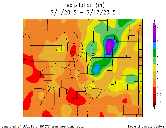
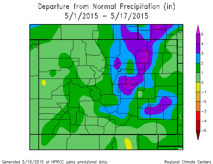
The unprecedented wet May conditions continue over most of the state. East of the Divide, soils continue to stay saturated with May precipitation already running at up to 5-fold above average! The lack of sunshine has kept temperatures unseasonably cold with most locations running 4-6F below average. West of the Divide, late season snow and rains are doing wonders to help the drought situation. Most of Colorado may be drought free should the continuous rains keep falling over the next few weeks. And it appears they will.

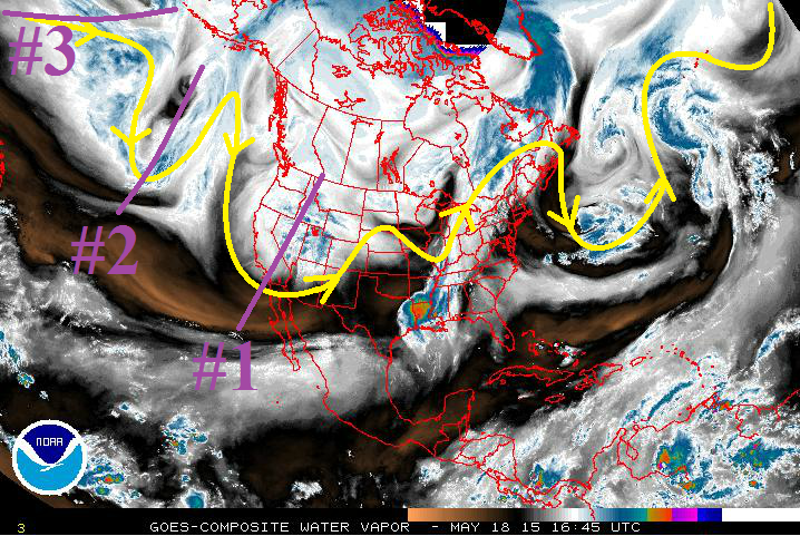
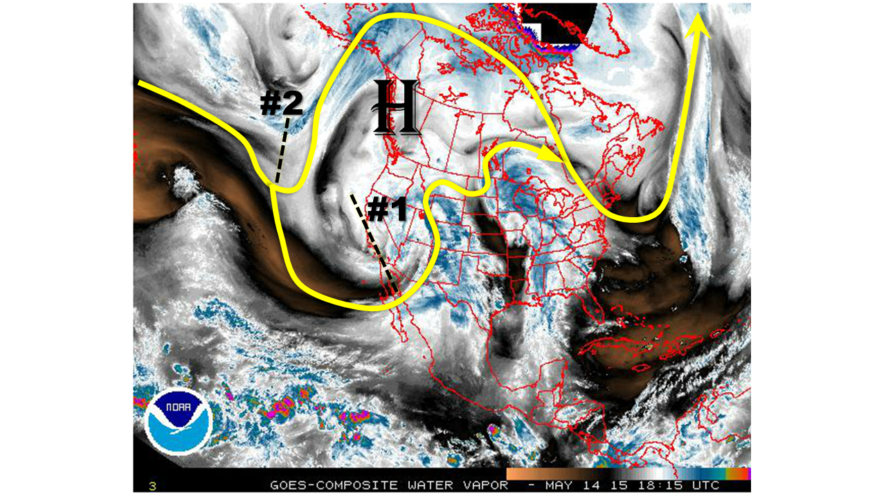
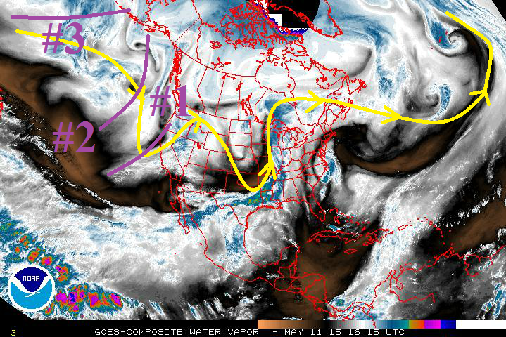
The active feed of subtropical disturbances will continue. As shown by the water vapor image, below, a “split-flow” pattern continues to be active off the west coast of North America. In such a pattern, a blocking high sets up over Northwest Canada (or sometimes south of Alaska) and diverts the main jet stream well to the north. Meanwhile, a separate subtropical jet stream separates from the main jet stream and produces disturbances that frequently cause rainfall across the southwest U.S., including Colorado.

watervapor_20150521

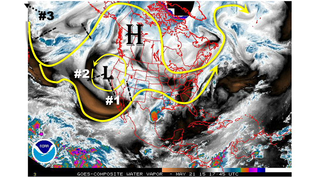
Over the next two weeks, we continue to foresee this pattern creating many disturbances that will move across our state. Overall, the pattern will be particularly busy through Memorial Day weekend (Events #1 and 2 on the water vapor image), followed by 3-5 days of overall quieter weather. However, even during the “quieter” weather period, there will likely be scattered thunderstorm activity especially over the higher terrain. We do not expect this activity to add up to much rainfall. Then, a re-invigoration of active weather (Event #3) will occur from a disturbance that is currently over the western Pacific Ocean.

The three events that we have identified are:

  • Event #1: Friday (May 22)
    • Light to moderate precipitation mainly east of the Continental Divide.
    • Elevated flood threat for Northeast Plains due to saturated conditions.
  • Event #2: Sunday through Memorial Day (May 24-25)
    • Cut-off will approach Colorado causing moderate to heavy rainfall, mainly across the northern half of the state
    • Elevated flood threat due to saturated conditions and large snowpack across the Continental Divide
  • Event #3: Next Sunday through Tuesday (May 31-June 2)
    • A large-scale disturbance with a familiar cut-off look will approach Colorado next weekend
    • The combination of strong dynamics and potential subtropical moisture will cause an elevated flood threat for a 2-3 day period

Event #1: Friday (May 22)

An Elevated Flood Threat For The Northeast Plains

A disturbance will quickly move across the state on Friday, limiting the rainfall potential. However, strong to severe thunderstorms will be likely over the Northeast Plains. Large hail and strong winds will be possible, and stronger thunderstorms could cause very heavy rainfall leading to flash flooding over the already saturated soils.

Legend


Event #2: Sunday (May 24)

Elevated Flood Threat For Northern Mountains and Front Range Due To “Rain-on-Snow”

The cut-off low off the California coast will drift over Colorado on Sunday setting the stage for a widespread rainfall event. While most areas will not see more than 0.5 inch of rain, the Northern Mountains and Front Range foothills could see amounts over 1 inch. Due to the large snowpack currently in place, and elevated flood threat is issued for that region for minor stream flooding. Hikers and campers should monitor NWS watches and warnings for their particular region of interest.

Legend

Event #3: Friday (5-22-2015) through Sunday (5-24-2015)

An Elevated Flood Threat Will Likely Exist, But Exact Location Is Not Set In Stone

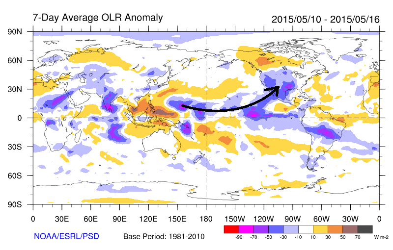
After a week of relatively quieter and warmer weather, it looks like Mother Nature will conspire to form another large-scale disturbance off the North American coast. While similar to past disturbances, this feature may have the extra “benefit” of having direct access to moisture from a potentially strong tropical disturbance south of the Baja of California. Such a setup has all the necessary features for a heavy rainfall threat across Colorado this time of year. Currently, the model guidance and our intuition suggests the largest threat in the Southeast Plains and Raton Ridge, but we will refine this area as the event draws nearer.

Legend

FTO 05-18-2015: The Storm Track Continues To Be Active

Issue Date: 5/18/2015
Issue Time: 2:30 PM

Threat_Timeline_20150518

Once again, the active storm track lays across Colorado, and will allow for disturbances to pass through fairly routinely throughout the period. The active storm track shows up really well in the water vapor image below (the yellow line). Over the next 15 days, there are 3 events (marked by purple lines/numbers) for which this FTO will be focused upon.

  • Event #1: Tuesday (5-19-2015) and Wednesday (5-20-2015)
    • Today’s Flood Threat Bulletin covered the first stages of this event, so this discussion will focus on its impacts beginning on Tuesday. For Tuesday morning through evening, the upper-level trough will be still in place over Colorado, before moving from the state Tuesday night. On Wednesday, the remnant moisture/orographic forcing will provide a few showers and thunderstorms over the higher terrain.
  • Event #2: Thursday (5-21-2015) through Sunday night (5-24-2015)
    • Another trough will move southward into California on Thursday, placing Colorado under southwesterly flow once again. This transient upper-level system will work across Colorado through Sunday, bringing another weekend wet period.
  • Event #3: Wednesday (5-27-2015) through Saturday (5-30-2015)
    • Still building near the Aleutian Islands, this storm system is not well-resolved by the models at this time. Observationally, it can be seen in satellite imagery, so we know that it is there. Following the forecast trend of the storm track over the last few weeks, it will likely begin an unsettled period beginning during mid-week next week, lasting into the weekend.

20150518_WV

For a quick look at the past 17 days, the National Weather Service in Pueblo, CO, has produced these graphics showing just how wet it has been across Colorado for the first half of May. As you can see, everyone across Colorado, except for a small area in Mesa County, has experienced normal/above-normal precipitation so far this month.

May1-17PrecipMay1-17Departure


Now for a look ahead in the longer time-frame, we are watching the continuing of El Nino. We have made reference to it in every FTO so far this summer, and this FTO will be no different. The tropical Pacific Ocean is at least partly responsible for the wet start to the summer here in Colorado.

WeeklySST_0518

In contrast to conditions last year, which also featured a weak El Nino, recently we have seen a coupling between the SST anomalies and the overlying atmosphere. The map below shows the radiance of the atmosphere, as seen by satellites. What is important to note is that negative values imply cloudiness, while positive values generally imply clear skies. Note that there is a connection from the blue and purple colors close to the equator all the way to the Southwest U.S. This implies copious amounts of subtropical moisture being ingested into disturbances, which partly explains all the cloudy days over the past several weeks.

7DayAvgOLR_5May6-May12

Event #1: Tuesday (5-19-2015) and Wednesday (5-20-2015)

Elevated Flood Threat Early, Then Diminishing by Tuesday Night

The best shot at heavy rain/flash flooding with this system will occur early Tuesday morning, gradually slacking off by Tuesday evening. By Tuesday night, the upper-level trough will move out of the state, and cool, surface high pressure will have filtered in along with a flattened upper-level ridge. This will put a stable airmass in place over eastern Colorado, with the best chance at showers and a few thunderstorms over the higher terrain on Wednesday. A few of the storms will briefly move over the Urban Corridor, Palmer Ride, and adjacent plains before diminishing quickly in the cooler, more stable air.

Legend

Event #2: Thursday (5-21-2015) through Sunday (5-24-2015)

Elevated Flood Threat Developing, Antecedent Moisture Shouldn’t Be Discounted

Another weekend, another upper-level system forecast to move across the southwest US. For Thursday morning, high pressure will be in place over the Plains, meaning most of the showers and thunderstorms will occur over the higher terrain. This upper-level system will be fairly transient, not wasting anytime over California before moving east/northeast. So, by late Thursday night/early Friday morning, expect shower/thunderstorm activity to pick up statewide, once again. There will be a threat for severe weather over the Plains on Friday and Saturday, depending on how the moisture profile sets up. Keep an eye on this in upcoming FTB’s. Then, as the low moves east on Sunday, activity will diminish from west to east.

Legend

Event #3: Wednesday (5-27-2015) through Saturday (5-30-2015)

No Apparent Flood Threat as Storm is Still Coming Together

This period will bear watching as the storm system continues to gather itself near the Aleutian Islands. Past trends along this storm track lend a hand in forecasting the timing of occurrence, but not the exact locations of heaviest rain/rainfall amounts. Therefore, this map is empty, but will fill in subsequent FTO’s. Stay tuned.

Legend

FTO 05-14-2015: Mother Nature Churning Out Hit After Hit On Colorado, With Help From Subtropical Connection

Issue Date: 5/14/2015
Issue Time: 3:15 PM

threat_timeline_20150514

East of the Continental Divide, the lush green fields and forests of our state are a good indication that the spring rains and snows have kept the ground well fed with water. West of the Continental Divide and across the extreme southeast portion of the state, a somewhat different picture emerges with below average spring snowpack and precipitation still causing moderate to severe drought conditions. However, the recent weather pattern has acted to ease the drought conditions. The times of plentiful precipitation are likely to continue over the roughly two week period of this edition of the Flood Threat Outlook.

Over the next 15 days, three separate precipitation Events have been identified:

  • Event #1: Friday (5-15-2015) through Sunday (5-17-2015)
    • A snowstorm for the San Juan and Central Mountains. No flood threat is expected.
  • Event #2: Tuesday (5-18-2015) through Wednesday (5-19-2015)
    • The passage of a cool front will set the stage for an Elevated flood threat, especially in the Southeast Plains.
  • Event #3: Friday (5-22-2015) through Sunday (5-24-2015)
    • Another disturbance looks to trek into Colorado. At this time, no flood threat is apparent.

The water vapor image below shows the “wavetrain” over North America. As has been the case for the past few weeks, a common recurring theme has been the presence of low-pressure systems over the southwest U.S. Another such system is noted today, which will set the stage for Event #1. However, also pay particular attention to the strong high pressure system noted west of the North American coast. The position of this system is so far north that it is acting to block the atmospheric flow, implying that systems are being redirected southward into the southwestern U.S. Note that such a pattern is common during early spring, but quite uncommon so late in the spring season. Event #2 is evident over the North Pacific Ocean as a disturbance. It will also be diverted southward and move over Colorado by early to middle of next week. Finally, a third disturbance, which does not show up on the map below, may deliver more precipitation to Colorado late next week. But, we must wait several days to determine if this will cause a flood threat.

watervapor_20150514

It looks like part of the explanation for the active weather pattern can be deduced from what is happening in the tropical Pacific Ocean. We have made reference to the fact that there is a weak El Nino currently in place, as shown by the latest weekly SST anomaly map below.

SSTA_20150514

In contrast to conditions last year, which also featured a weak El Nino, recently we have seen a coupling between the SST anomalies and the overlying atmosphere. The map below shows the radiance of the atmosphere, as seen by satellites. What is important to note is that negative values imply cloudiness, while positive values generally imply clear skies. Note that there is a connection from the blue and purple colors close to the equator all the way to the Southwest U.S. This implies copious amounts of subtropical moisture being ingested into disturbances, which partly explains all the cloudy days over the past several weeks!

OLRA_20150514


Event #1: Friday (5-15-2015) through Sunday (5-17-2015)

No Apparent Flood Threat

A cut-off low pressure system will once again impact Colorado. This time, the moisture feed will mainly affect areas west of the Continental Divide. Over an inch of precipitation over the higher terrain of the San Juan and Central mountains. However, instability will be lacking, which will keep precipitation rates to levels that do not warrant a flood threat. Heavy mountain snows will be likely in the San Juans, which will ease the moderate to severe drought conditions in the area.

Legend

Event #2: Tuesday (5-19-2015) through Wednesday (5-20-2015)

Elevated Flood Threat Likely East of the Continental Divide

A cool front will pass through eastern Colorado after the weekend storm, which could setup a stationary frontal boundary somewhere between the Palmer Ridge and the New Mexico borders. Stationary fronts are notorious for providing Colorado with rainfall. This time, the stationary front will be aided by atmospheric dynamics arriving from the southwest by early Tuesday. Heavy rains over 1 inch will be likely over areas east of the Divide. Instability may be a wildcard with this storm and may limit the flood threat to areas farther south.


Legend

Event #3: Friday (5-22-2015) through Sunday (5-24-2015)

No Apparent Flood Threat

The blocking high pattern noted on the water vapor imagery appears to persist through the end of next week, leading to the potential for another cut-off low to impact the area. Model agreement is poor at this time, because blocking patterns tend to slow the progression of individual disturbances. However, at this time, it appears the southern half of Colorado will experience all the necessary ingredients for a heavy rainfall threat.


Legend

FTO 05-11-2015: Three More Events on the Horizon in the Next 15 Days

Issue Date: 5/11/2015
Issue Time: 2:35 PM

Threat_Timeline_20150511

After a cool, wet start to May, the next 15 days look to be no different. The active storm track will allow for disturbances to pass over Colorado fairly routinely. So, we turn our eyes to the future…

Over the next 15 days, there are 3 events for which this FTO will be focused upon.

  • Event #1: Tuesday (5-12-2015) through Thursday night (5-14-2015)
    • This mid-/upper-level system will drop southward along the west coast by the end of today (05/11), and will put Colorado under moist, southwest flow once again. This will bring scattered showers and thunderstorms to the state before spinning relatively quickly off to the east-northeast.
  • Event #2: Friday afternoon (5-15-2015) through Wednesday evening (5-20-2015)
    • This system mirrors a lot of what we saw this last week; a low that centers itself over the West Coast, with a decent stream of moisture (and numerous embedded disturbances) funneling into Colorado. This system will be a bit more transient than the event of May 1-May 10, moving east of the area in a quicker fashion.
  • Event #3: Thursday afternoon (5-21-2015) through Tuesday (5-26-2015)
    • The hits just keep on coming, as this third event runs down the well-established storm track, bringing another wet and unsettled period to Colorado. You can find it marked on the water vapor image below with purple line #3, gathering itself over the northern Pacific. A relatively high amount of moisture is embedded with this disturbance at the present time, so it will be necessary to monitor closely as we move forward.

05112015_WV


In the longer time-frame, we are watching the continuing of El Nino. With El Nino in place, we have seen a very wet start to the summer here in Colorado, and the wet weather looks to persist over the next 15 days. The continuing of El Nino will be important to keep our eye on as the flooding season progresses. Look for more updates in the coming FTO’s.

20150511_SeasonalSST


Event #1: Tuesday (5-12-2015) through Thursday night (5-14-2015)

No Apparent Flood Threat

The upper-level low for Event #2 is the “parent” of the upper-level low known as Event #1. Event #1 will provide another shot at unsettled, wet weather for Colorado, though this will be the most transient event of the three. Moisture will not be deep enough to cause widespread flash flooding concerns, as most of the moderate-to-heavy rain threat will over the northeastern Plains. With that said, due to the nature of this type of event, be sure to pay attention to the daily FTB forecasts for the most up-to-date information.

Legend

Event #2: Friday afternoon (5-15-2015) through Wednesday evening (5-20-2015)

Elevated Flood Threat Taking Shape

Another extended period of unsettled weather is on the horizon for Colorado. This event will shift the precipitation maxima on the plains southward as compared to the May 1 – May 10 event, along with widespread 1+ inch liquid precipitation to the mountains. At this time, it appears that the likeliest location for flash flooding to develop will be the Palmer Ridge and Southeastern Plains, but stay tuned to more updates in the Thursday FTO and subsequent FTB’s.

Legend

Event #3: Thursday afternoon (5-21-2015) through Tuesday (5-26-2015)

Elevated Flood Threat Developing

I’m trying not to sound like a broken record, but it is difficult to find different ways to say “extended period of wet, unsettled weather.” At this time, a high degree of uncertainty exists regarding the evolution of this system, but it appears to be substantial. A relatively high amount of moisture is present with this disturbance as it gathers itself over the Northern Pacific, leading to the concern that a flood threat will develop from this event. This system will come further into focus in the coming days, so stay tuned for Thursday’s FTO and an update on this system.

Legend