Issue Date: 5/14/2015
Issue Time: 3:15 PM

East of the Continental Divide, the lush green fields and forests of our state are a good indication that the spring rains and snows have kept the ground well fed with water. West of the Continental Divide and across the extreme southeast portion of the state, a somewhat different picture emerges with below average spring snowpack and precipitation still causing moderate to severe drought conditions. However, the recent weather pattern has acted to ease the drought conditions. The times of plentiful precipitation are likely to continue over the roughly two week period of this edition of the Flood Threat Outlook.
Over the next 15 days, three separate precipitation Events have been identified:
- Event #1: Friday (5-15-2015) through Sunday (5-17-2015)
- A snowstorm for the San Juan and Central Mountains. No flood threat is expected.
- Event #2: Tuesday (5-18-2015) through Wednesday (5-19-2015)
- The passage of a cool front will set the stage for an Elevated flood threat, especially in the Southeast Plains.
- Event #3: Friday (5-22-2015) through Sunday (5-24-2015)
- Another disturbance looks to trek into Colorado. At this time, no flood threat is apparent.
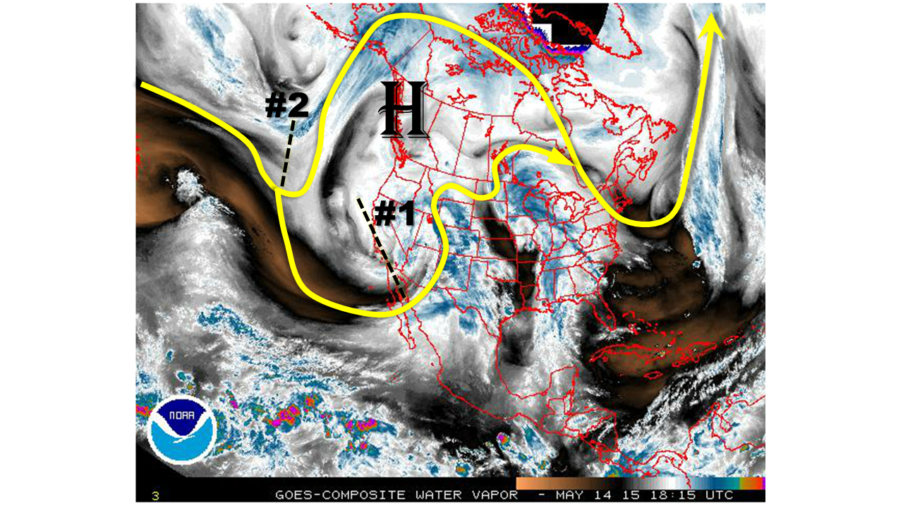
The water vapor image below shows the “wavetrain” over North America. As has been the case for the past few weeks, a common recurring theme has been the presence of low-pressure systems over the southwest U.S. Another such system is noted today, which will set the stage for Event #1. However, also pay particular attention to the strong high pressure system noted west of the North American coast. The position of this system is so far north that it is acting to block the atmospheric flow, implying that systems are being redirected southward into the southwestern U.S. Note that such a pattern is common during early spring, but quite uncommon so late in the spring season. Event #2 is evident over the North Pacific Ocean as a disturbance. It will also be diverted southward and move over Colorado by early to middle of next week. Finally, a third disturbance, which does not show up on the map below, may deliver more precipitation to Colorado late next week. But, we must wait several days to determine if this will cause a flood threat.
It looks like part of the explanation for the active weather pattern can be deduced from what is happening in the tropical Pacific Ocean. We have made reference to the fact that there is a weak El Nino currently in place, as shown by the latest weekly SST anomaly map below.
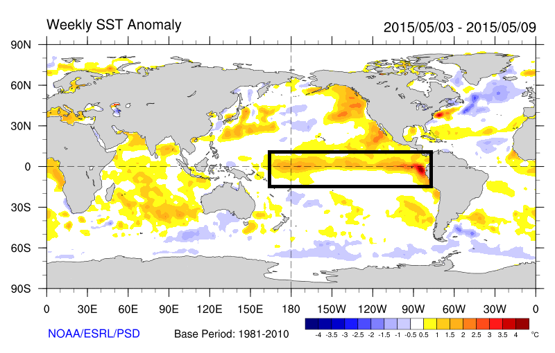
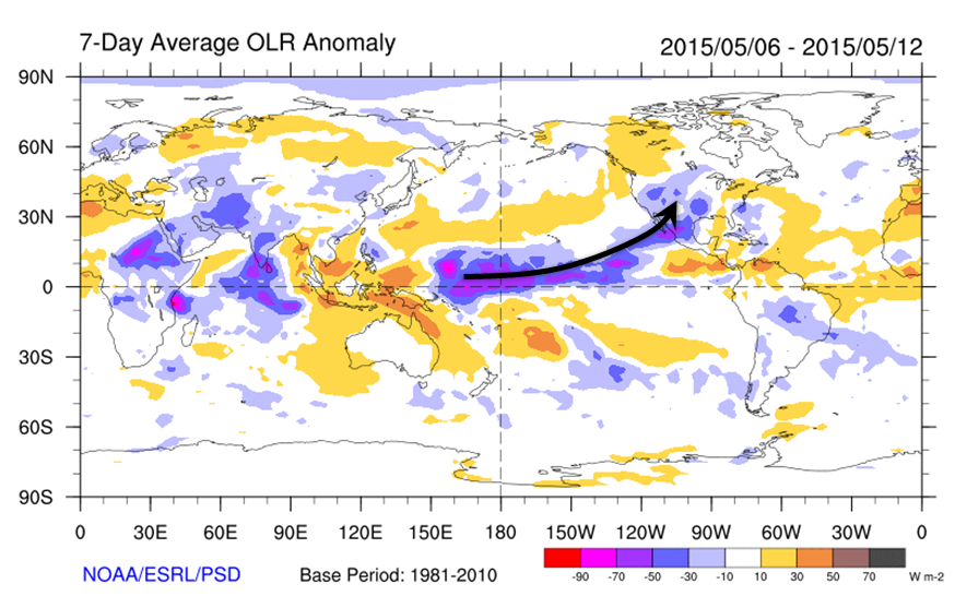
In contrast to conditions last year, which also featured a weak El Nino, recently we have seen a coupling between the SST anomalies and the overlying atmosphere. The map below shows the radiance of the atmosphere, as seen by satellites. What is important to note is that negative values imply cloudiness, while positive values generally imply clear skies. Note that there is a connection from the blue and purple colors close to the equator all the way to the Southwest U.S. This implies copious amounts of subtropical moisture being ingested into disturbances, which partly explains all the cloudy days over the past several weeks!
Event #1: Friday (5-15-2015) through Sunday (5-17-2015)
No Apparent Flood Threat
A cut-off low pressure system will once again impact Colorado. This time, the moisture feed will mainly affect areas west of the Continental Divide. Over an inch of precipitation over the higher terrain of the San Juan and Central mountains. However, instability will be lacking, which will keep precipitation rates to levels that do not warrant a flood threat. Heavy mountain snows will be likely in the San Juans, which will ease the moderate to severe drought conditions in the area.
Event #2: Tuesday (5-19-2015) through Wednesday (5-20-2015)
Elevated Flood Threat Likely East of the Continental Divide
A cool front will pass through eastern Colorado after the weekend storm, which could setup a stationary frontal boundary somewhere between the Palmer Ridge and the New Mexico borders. Stationary fronts are notorious for providing Colorado with rainfall. This time, the stationary front will be aided by atmospheric dynamics arriving from the southwest by early Tuesday. Heavy rains over 1 inch will be likely over areas east of the Divide. Instability may be a wildcard with this storm and may limit the flood threat to areas farther south.
Event #3: Friday (5-22-2015) through Sunday (5-24-2015)
No Apparent Flood Threat
The blocking high pattern noted on the water vapor imagery appears to persist through the end of next week, leading to the potential for another cut-off low to impact the area. Model agreement is poor at this time, because blocking patterns tend to slow the progression of individual disturbances. However, at this time, it appears the southern half of Colorado will experience all the necessary ingredients for a heavy rainfall threat.