Issue Date: 5/18/2015
Issue Time: 2:30 PM

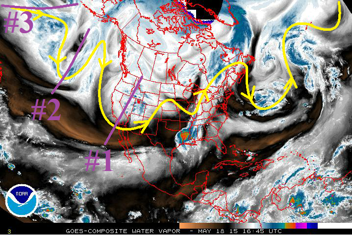
Once again, the active storm track lays across Colorado, and will allow for disturbances to pass through fairly routinely throughout the period. The active storm track shows up really well in the water vapor image below (the yellow line). Over the next 15 days, there are 3 events (marked by purple lines/numbers) for which this FTO will be focused upon.
- Event #1: Tuesday (5-19-2015) and Wednesday (5-20-2015)
- Today’s Flood Threat Bulletin covered the first stages of this event, so this discussion will focus on its impacts beginning on Tuesday. For Tuesday morning through evening, the upper-level trough will be still in place over Colorado, before moving from the state Tuesday night. On Wednesday, the remnant moisture/orographic forcing will provide a few showers and thunderstorms over the higher terrain.
- Event #2: Thursday (5-21-2015) through Sunday night (5-24-2015)
- Another trough will move southward into California on Thursday, placing Colorado under southwesterly flow once again. This transient upper-level system will work across Colorado through Sunday, bringing another weekend wet period.
- Event #3: Wednesday (5-27-2015) through Saturday (5-30-2015)
- Still building near the Aleutian Islands, this storm system is not well-resolved by the models at this time. Observationally, it can be seen in satellite imagery, so we know that it is there. Following the forecast trend of the storm track over the last few weeks, it will likely begin an unsettled period beginning during mid-week next week, lasting into the weekend.
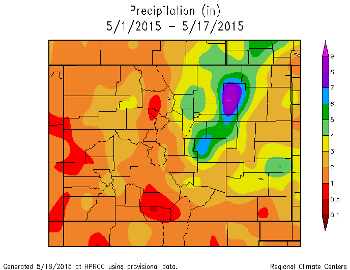
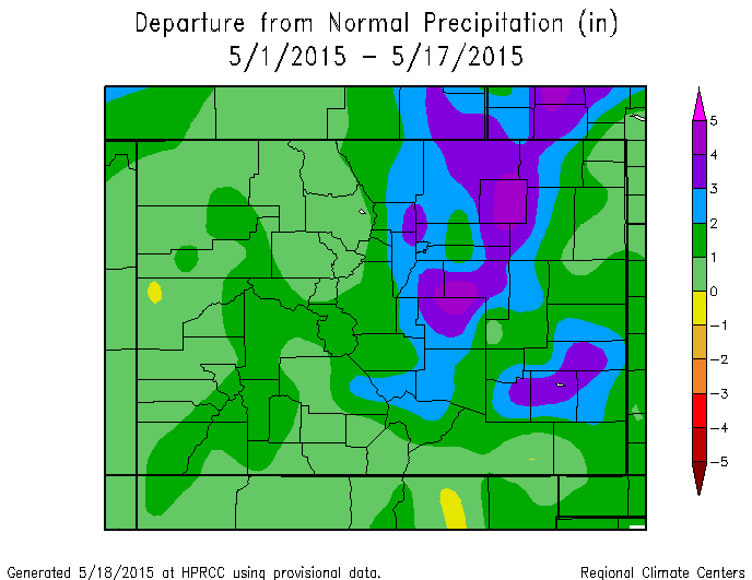
For a quick look at the past 17 days, the National Weather Service in Pueblo, CO, has produced these graphics showing just how wet it has been across Colorado for the first half of May. As you can see, everyone across Colorado, except for a small area in Mesa County, has experienced normal/above-normal precipitation so far this month.
Now for a look ahead in the longer time-frame, we are watching the continuing of El Nino. We have made reference to it in every FTO so far this summer, and this FTO will be no different. The tropical Pacific Ocean is at least partly responsible for the wet start to the summer here in Colorado.
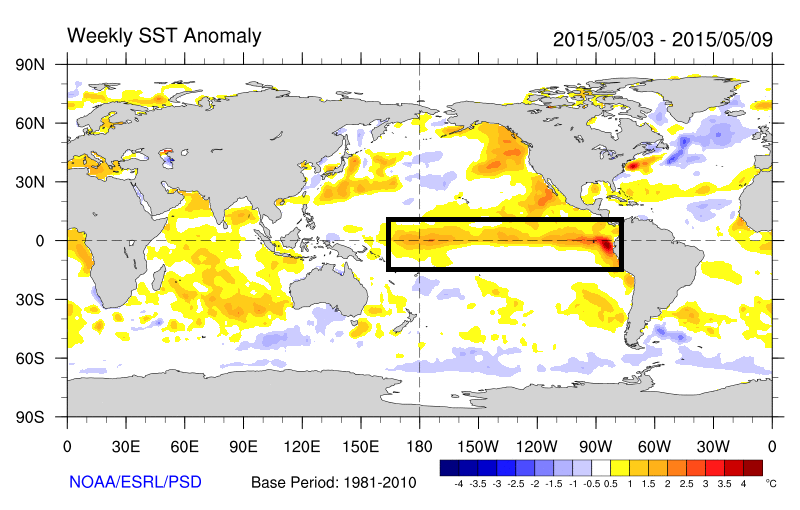
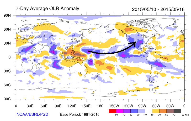
In contrast to conditions last year, which also featured a weak El Nino, recently we have seen a coupling between the SST anomalies and the overlying atmosphere. The map below shows the radiance of the atmosphere, as seen by satellites. What is important to note is that negative values imply cloudiness, while positive values generally imply clear skies. Note that there is a connection from the blue and purple colors close to the equator all the way to the Southwest U.S. This implies copious amounts of subtropical moisture being ingested into disturbances, which partly explains all the cloudy days over the past several weeks.
Event #1: Tuesday (5-19-2015) and Wednesday (5-20-2015)
Elevated Flood Threat Early, Then Diminishing by Tuesday Night
The best shot at heavy rain/flash flooding with this system will occur early Tuesday morning, gradually slacking off by Tuesday evening. By Tuesday night, the upper-level trough will move out of the state, and cool, surface high pressure will have filtered in along with a flattened upper-level ridge. This will put a stable airmass in place over eastern Colorado, with the best chance at showers and a few thunderstorms over the higher terrain on Wednesday. A few of the storms will briefly move over the Urban Corridor, Palmer Ride, and adjacent plains before diminishing quickly in the cooler, more stable air.

Event #2: Thursday (5-21-2015) through Sunday (5-24-2015)
Elevated Flood Threat Developing, Antecedent Moisture Shouldn’t Be Discounted
Another weekend, another upper-level system forecast to move across the southwest US. For Thursday morning, high pressure will be in place over the Plains, meaning most of the showers and thunderstorms will occur over the higher terrain. This upper-level system will be fairly transient, not wasting anytime over California before moving east/northeast. So, by late Thursday night/early Friday morning, expect shower/thunderstorm activity to pick up statewide, once again. There will be a threat for severe weather over the Plains on Friday and Saturday, depending on how the moisture profile sets up. Keep an eye on this in upcoming FTB’s. Then, as the low moves east on Sunday, activity will diminish from west to east.
Event #3: Wednesday (5-27-2015) through Saturday (5-30-2015)
No Apparent Flood Threat as Storm is Still Coming Together
This period will bear watching as the storm system continues to gather itself near the Aleutian Islands. Past trends along this storm track lend a hand in forecasting the timing of occurrence, but not the exact locations of heaviest rain/rainfall amounts. Therefore, this map is empty, but will fill in subsequent FTO’s. Stay tuned.