Issue Date: 5/11/2015
Issue Time: 2:35 PM

After a cool, wet start to May, the next 15 days look to be no different. The active storm track will allow for disturbances to pass over Colorado fairly routinely. So, we turn our eyes to the future…
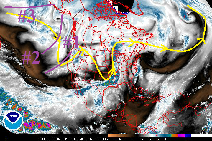
Over the next 15 days, there are 3 events for which this FTO will be focused upon.
- Event #1: Tuesday (5-12-2015) through Thursday night (5-14-2015)
- This mid-/upper-level system will drop southward along the west coast by the end of today (05/11), and will put Colorado under moist, southwest flow once again. This will bring scattered showers and thunderstorms to the state before spinning relatively quickly off to the east-northeast.
- Event #2: Friday afternoon (5-15-2015) through Wednesday evening (5-20-2015)
- This system mirrors a lot of what we saw this last week; a low that centers itself over the West Coast, with a decent stream of moisture (and numerous embedded disturbances) funneling into Colorado. This system will be a bit more transient than the event of May 1-May 10, moving east of the area in a quicker fashion.
- Event #3: Thursday afternoon (5-21-2015) through Tuesday (5-26-2015)
- The hits just keep on coming, as this third event runs down the well-established storm track, bringing another wet and unsettled period to Colorado. You can find it marked on the water vapor image below with purple line #3, gathering itself over the northern Pacific. A relatively high amount of moisture is embedded with this disturbance at the present time, so it will be necessary to monitor closely as we move forward.
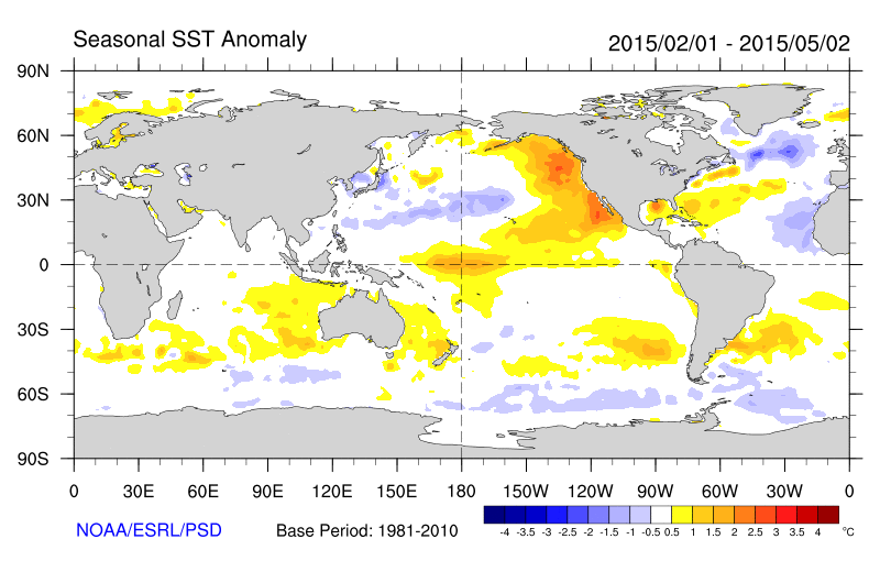
In the longer time-frame, we are watching the continuing of El Nino. With El Nino in place, we have seen a very wet start to the summer here in Colorado, and the wet weather looks to persist over the next 15 days. The continuing of El Nino will be important to keep our eye on as the flooding season progresses. Look for more updates in the coming FTO’s.
Event #1: Tuesday (5-12-2015) through Thursday night (5-14-2015)
No Apparent Flood Threat
The upper-level low for Event #2 is the “parent” of the upper-level low known as Event #1. Event #1 will provide another shot at unsettled, wet weather for Colorado, though this will be the most transient event of the three. Moisture will not be deep enough to cause widespread flash flooding concerns, as most of the moderate-to-heavy rain threat will over the northeastern Plains. With that said, due to the nature of this type of event, be sure to pay attention to the daily FTB forecasts for the most up-to-date information.

Event #2: Friday afternoon (5-15-2015) through Wednesday evening (5-20-2015)
Elevated Flood Threat Taking Shape
Another extended period of unsettled weather is on the horizon for Colorado. This event will shift the precipitation maxima on the plains southward as compared to the May 1 – May 10 event, along with widespread 1+ inch liquid precipitation to the mountains. At this time, it appears that the likeliest location for flash flooding to develop will be the Palmer Ridge and Southeastern Plains, but stay tuned to more updates in the Thursday FTO and subsequent FTB’s.
Event #3: Thursday afternoon (5-21-2015) through Tuesday (5-26-2015)
Elevated Flood Threat Developing
I’m trying not to sound like a broken record, but it is difficult to find different ways to say “extended period of wet, unsettled weather.” At this time, a high degree of uncertainty exists regarding the evolution of this system, but it appears to be substantial. A relatively high amount of moisture is present with this disturbance as it gathers itself over the Northern Pacific, leading to the concern that a flood threat will develop from this event. This system will come further into focus in the coming days, so stay tuned for Thursday’s FTO and an update on this system.