FTO 07-30-2015: Elevated Flood Threat To Persist As Monsoon Spigot Turns On

Issue Date: 7/30/2015
Issue Time: 2:30PM
Valid dates: 7/31 – 8/14

Overview threat_timeline.20150730

Moisture. That is quite possibly the single most important variable in the equation for heavy rainfall across Colorado during the summer. If it is present, even benign conditions, such as strong solar heating, can cause thunderstorm activity. If it is not present, even a strong atmospheric disturbance can end up producing storms with gusty winds, but only a few raindrops. This summer, moisture has seemingly been in never-ending supply. A few weeks ago, we published this Twitter post showing that it has been the most humid summer in Denver since at least 1961:


Fast forward to today, and we have continued to see a very humid summer in Colorado, with almost daily thunderstorm activity at least somewhere across the state.

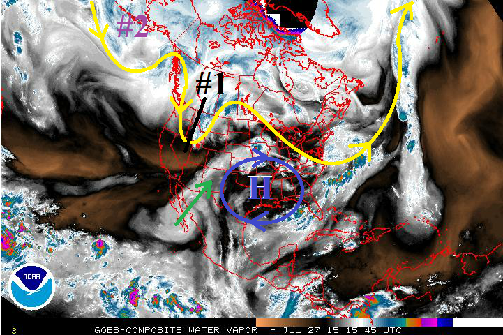
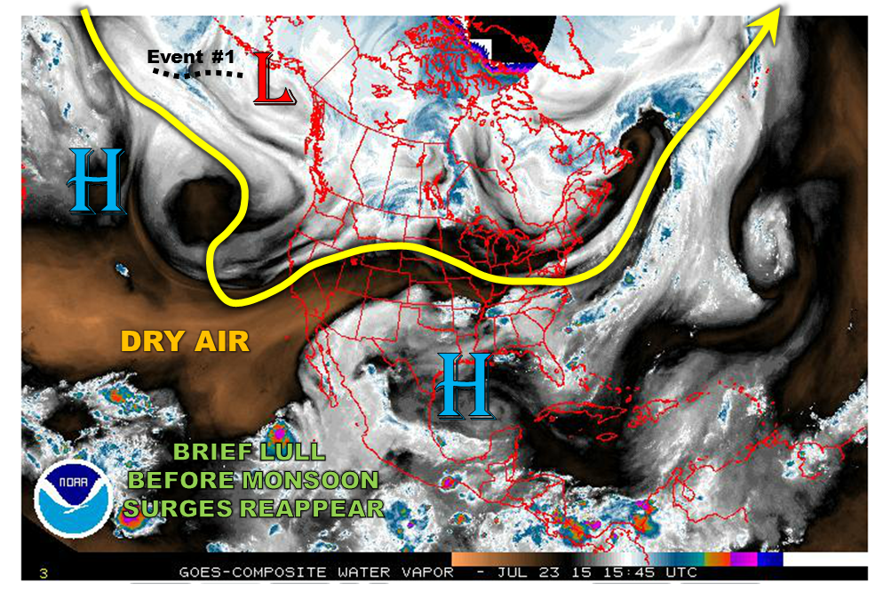
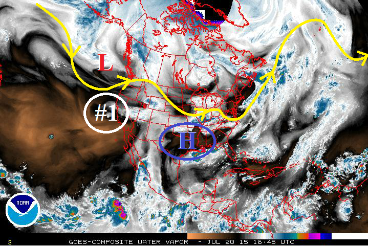
For this Flood Threat Outlook, all indications point to a continuation of active weather across Colorado. In particular, we anticipate two separate heavy rainfall periods over the next 15 days. Now on to the details. The water vapor image, below, shows a disturbance positioned off the California coast. Instead of following a typical eastward movement, this disturbance will actually move south, or “dig” deeper into the subtropics. To its east, we see a return flow of subtropical monsoonal moisture that is currently providing active weather from Southern California all the way to New Mexico.

watervapor_20150730

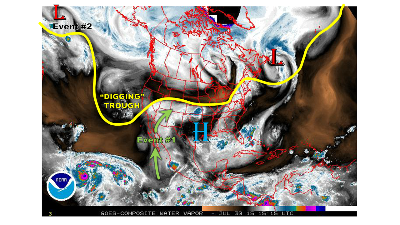
This latest push of subtropical moisture is some of the highest of the season, as is seen by looking at the Precipitable Water chart for Albuquerque, NM since May 1st. Note that values have recently been in the 1.3 to 1.4 inch range, which is in the 98th percentile based on the region’s climatology.ABQ_ipw
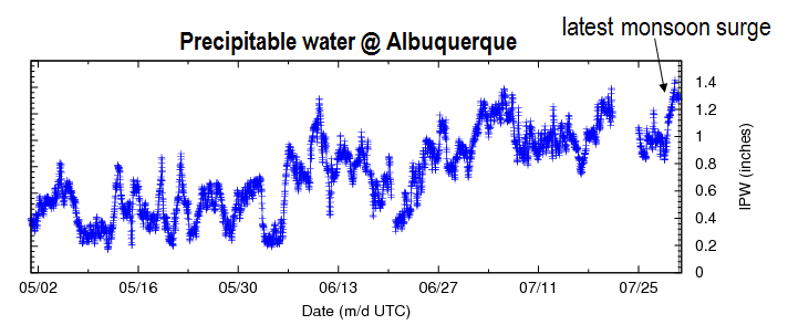
As the aforementioned trough digs deeper, moisture will continue to trickle into the four corners region. This will support a prolonged 4 day period of wet weather, mainly across southwest Colorado (Event #1). After Event #1, there will be a lull, as the monsoon connection is severed for a few days. But by late next week, another period of unsettled weather will start as a disturbance currently in the west Pacific migrates towards Colorado (Event #2). It appears that this event may be focused east of the Divide. Looking out past Event #2, there are indications of more active weather. However, at this time, we cannot confidently pinpoint the timeframe, or region most under threat. We will reinvestigate these details during the next update of the Flood Threat Outlook on Monday, 8/3. Stay tuned.

Now we look at the details of the two flood threat Events:

Event #1: Friday (7/31) – Monday (8/3)

An Elevated flood threat as a stubborn plume of subtropical moisture impacts mainly southwest CO

The digging disturbance off the California coast will send moisture into southwest Colorado, resulting in daily afternoon and evening thunderstorm activity. The region under the highest threat is the San Juan mountains, where upslope flow will result in heavy rainfall threat every day. Over the entire period, over 2 inches of rainfall can be anticipated for localized areas of the San Juans, with lesser totals to the north and even as far eastward as the Southeast Plains. In addition to an elevated flash flooding risk, isolated mud flows and debris slides can be anticipated with this event.


Legend

Event #2: Thursday (8/6) through Saturday (8/8)

An Elevated flood threat, mainly east of the Divide

A disturbance will trek all the way across the Pacific Ocean (see water vapor image) and impact Colorado by later next week. As this disturbance will likely be coming in from the west/northwest, it appears that the monsoonal connection may be limited. We anticipate that the Northeast Plains will be under the highest threat for heavy rainfall as a cool front makes its way down the east face of the Rockies, promoting easterly upslope flow. In additional to the rainfall threat, since this disturbance will be accompanied by jet stream dynamics, hail and strong winds may be possible. At this time it appears that the disturbance will keep moving east. However, it is possible, that the cool front will sag all the way into southeast Colorado, which will increase rainfall chances there too. We anticipate to have a much better grasp on this setup in the Flood Threat Outlook, on Monday 8/3.

Legend

FTO 07-27-2015: Transition to Monsoon Season Underway

Issue Date: 7/27/2015
Issue Time: 1:20 PM

Threat_Timeline_07272015

As we quickly move into August, it is a good time to remind everyone that this time period is when Colorado typically sees the Southwest Monsoon become a more frequent player in day-to-day weather. Monsoon surges arrive and are then cut-off, arrive and then cut-off, and so on and so forth. This FTO will certainly show no exception to this typical pattern. The first wet period covers Tuesday and Wednesday (07/28-07/29), and the second shows up for next week, Tuesday through Friday (08/04-08-07). Between the two periods, mostly sunny skies and warmth are expected to dominate most areas, with the typical summertime thunderstorms developing thanks to the presence of residual moisture under the upper-level ridge. After the second wet period, mostly sunny skies and hot temperatures are expected to return as the upper-level ridge builds overhead and cuts off the supply of subtropical moisture from the southwest. For more details, see the event discussions below.

07272015_WV

Event #1: Tuesday (7-28-2015) and Wednesday (7-29-2015)

Elevated Flood Threat as Upslope Flow and Monsoon Surge Impact Portions of Eastern Colorado

Upper-low (marked by black #1) will drag cool front through eastern Colorado early Tuesday, and this boundary will stall/washout along the CO/NM border for Tuesday/Wednesday. Upslope flow will develop behind the front, and underneath a modest monsoon surge (green arrow), will bring an elevated flood threat to southeastern Colorado, namely the southern Urban Corridor, Palmer Ridge, Southeast Plains (near the interface with Southeast Mountains), Southeast Mountains, and Raton Ridge. Precipitable water values will climb to near, or just above 1 inch for those areas mentioned, which will result in efficient rainfall production. Check back in for daily FTB’s for the most up-to-date information.

Legend

Event #2: Tuesday (8-4-2013) through Friday (8-7-2015)

Elevated Flood Threat for Extended Wet Period

An upper-level low pressure system (marked by purple “#2”) will take its time getting its act together, and will be delayed arrival to the west coast until early next week. The approach will force the upper-level high back to the east, bringing another monsoon surge to Colorado. This is expected to bring an extended period of showers and thunderstorms, as the high will take a few days to re-position itself westward and cutting off the flow of moisture from the southwest.

Legend

FTO 07-23-2015: Monsoon Surges and Cool Fronts Will Keep Rainfall Chances Elevated, Though Hot And Dry Days Will Also Be Seen

Issue Date: 7/23/2015
Issue Time: 2:30PM
Dates covered: 7/24 – 8/7

threat_timeline.20150723

As July transitions into August, the Southwest U.S. monsoon typically strengthens, providing increased rainfall chances to mainly central and southern Colorado. In particular, the regions seeing the highest average August rainfall are the Palmer Divide southward through the Sangre de Cristos as well as the San Juan Mountains. For this Flood Threat Outlook, covering July 24th through August 7th, it is precisely these areas that stand to receive the most rainfall across the state. However, it will not only be monsoon surges that support the rainfall chances. In fact, a relatively active storm track will send several Pacific cool fronts across the Rockies and into Colorado. And in between events, there will be several hot and dry days as the subtropical high pushes in from the south and southeast directions. A good example of this is today (Thursday 7/23), as seen by the water vapor image below. Despite waviness in the jet stream, dry air is being funneled from the southwest as two high pressures are in seen to be in control.

watervapor_20150723During the 15 day period covered by this Flood Threat Outlook, we see two precipitation events. The origin of the first is seen on the water vapor image above. It is a disturbance associated with a low pressure system over the Bering Sea. Meanwhile, the second event is not visible on the image above but is expected to develop as a consolidation of Central Pacific disturbances and tropical moisture reach Colorado. Now, on to the specifics:

Event #1: Monday (7/27) through Tuesday (7/28)

An Elevated Flood Threat as a cool front slowly pushes southward across Colorado

Starting Monday 7/27, a cool front and attendant low pressure system are expected to drop southeastward from the Canadian Rockies. This will temporarily shift low-level flow to the east and provide a good chance for heavy rainfall. It appears that the best threat will be east of the Divide, where up to 1.5 inches may fall. At this time, it also appears that most of the action will be on Monday. However, it is possible that the front is still draped across southeast Colorado on Tuesday, hence, a continuation of the threat until then.


Legend

Event #2: Saturday (8/1) through Tuesday (8/4)

A prolonged Elevated Flood Threat statewide as front and monsoon moisture will contribute to heavy rainfall

After several days of hot and dry weather, courtesy of the subtropical high, another disturbance will enter the west coast of North America. This disturbance will lead a frontal passage east of the Rockies. However, it appears that monsoon moisture will also be available from return flow as the subtropical high moves eastward. A prolonged active region is expected across Colorado starting on Saturday (8/1) west of the Divide and encompassing most of the state on Sunday and Monday, finally ending on Tuesday in southeast Colorado. Daily afternoon thunderstorms are expected, which will amount to as much as 2 inches in localized areas. More organized storm complexes may be possible in the Southeast Plains starting Sunday and Monday. As this event may eventually require a high threat, please check back next Monday as we update the Flood Threat Outlook.


Legend

FTO 07-20-2015: Two Elevated Flood Threat Events Separated by Hot and Dry Periods

Issue Date: 7/20/2015
Issue Time: 1:52 PM

Threat_Timeline_20150720

The next 15-day period is much like many of those before it, as an active storm track remains over the United States, albeit slightly offset further to the north. This means that fewer shortwave disturbances will track across Colorado during this FTO period as the active storm track invades northern states for a few weeks; only the strongest disturbances/upper-level troughs will be able to push back against the summertime high-pressure ridge. The first event marks two days in which the remnants of Hurricane Dolores are the main focus, and the second event will be the result of an upper-level trough able to push back against the ridge, bringing a fairly extended wet period from a monsoonal surge of moisture. Without further ado, let’s get right to it…

  • Event #1: Tuesday (07-21) and Wednesday (07-22)
    • Remnants of Hurricane Dolores (circled in white, #1) will keep Colorado sufficiently moist through Tuesday, with moisture waning as we move through Wednesday and into Thursday. The upper-level ridge over the south-central US (circled in blue) will continue to retrograde westward, cutting off the moist, southwest flow and drying out Colorado through Saturday with very little precipitation expected.
  • Event #2: Sunday (7-26) through Friday (07-31)
    • Event #2 is still gathering itself over the Bering Sea, so it is not quite in the view of our water vapor imagery below. This upper-level trough is forecast to begin working down the west coast of Canada on Friday, bringing southwest, monsoonal flow back to Colorado by late Saturday/early Sunday as it forces the upper-level ridge to the east, once again. This will provide an extended wet period (through Friday the 31st) before the main trough slides north and east of Colorado and the upper-level ridge retrogrades and regains its dominance over our weather.

WV_20150720


Event #1: Tuesday (07-21) and Wednesday (07-22)

Elevated Flood Threat, Mainly for Burn Scars, Urban Areas, and Unstable Terrain as Remnants of Dolores Move Overhead

Remnants of Hurricane Dolores will keep Colorado sufficiently moist through Tuesday, with moisture waning as we move through Wednesday and into Thursday. The most active day will be Tuesday thanks to the presence of deeper moisture, a passing weak disturbance, and greater instability as compared to Wednesday. Three-fourths or more of the total rainfall forecast for this two-day event will fall on Tuesday.

Legend

Event #2: Sunday (7-26) through Friday (07-31)

Elevated Flood Threat as Upper-Low and Monsoonal Surge Create an Extended Wet Period

Southwest, monsoonal flow will return to Colorado on Friday the 18th as an upper-level trough begins to work down the west coast of Canada, forcing the upper-level ridge to the east, once again. This extended cool, wet period will last for several days before the main trough moves north and east of Colorado and the upper-level ridge cuts off the monsoonal flow.

Legend