Issue Date: 7/27/2015
Issue Time: 1:20 PM

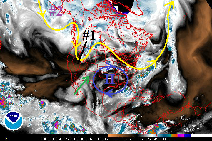
As we quickly move into August, it is a good time to remind everyone that this time period is when Colorado typically sees the Southwest Monsoon become a more frequent player in day-to-day weather. Monsoon surges arrive and are then cut-off, arrive and then cut-off, and so on and so forth. This FTO will certainly show no exception to this typical pattern. The first wet period covers Tuesday and Wednesday (07/28-07/29), and the second shows up for next week, Tuesday through Friday (08/04-08-07). Between the two periods, mostly sunny skies and warmth are expected to dominate most areas, with the typical summertime thunderstorms developing thanks to the presence of residual moisture under the upper-level ridge. After the second wet period, mostly sunny skies and hot temperatures are expected to return as the upper-level ridge builds overhead and cuts off the supply of subtropical moisture from the southwest. For more details, see the event discussions below.
Event #1: Tuesday (7-28-2015) and Wednesday (7-29-2015)
Elevated Flood Threat as Upslope Flow and Monsoon Surge Impact Portions of Eastern Colorado
Upper-low (marked by black #1) will drag cool front through eastern Colorado early Tuesday, and this boundary will stall/washout along the CO/NM border for Tuesday/Wednesday. Upslope flow will develop behind the front, and underneath a modest monsoon surge (green arrow), will bring an elevated flood threat to southeastern Colorado, namely the southern Urban Corridor, Palmer Ridge, Southeast Plains (near the interface with Southeast Mountains), Southeast Mountains, and Raton Ridge. Precipitable water values will climb to near, or just above 1 inch for those areas mentioned, which will result in efficient rainfall production. Check back in for daily FTB’s for the most up-to-date information.

Event #2: Tuesday (8-4-2013) through Friday (8-7-2015)
Elevated Flood Threat for Extended Wet Period
An upper-level low pressure system (marked by purple “#2”) will take its time getting its act together, and will be delayed arrival to the west coast until early next week. The approach will force the upper-level high back to the east, bringing another monsoon surge to Colorado. This is expected to bring an extended period of showers and thunderstorms, as the high will take a few days to re-position itself westward and cutting off the flow of moisture from the southwest.