Issue Date: 7/20/2015
Issue Time: 1:52 PM

The next 15-day period is much like many of those before it, as an active storm track remains over the United States, albeit slightly offset further to the north. This means that fewer shortwave disturbances will track across Colorado during this FTO period as the active storm track invades northern states for a few weeks; only the strongest disturbances/upper-level troughs will be able to push back against the summertime high-pressure ridge. The first event marks two days in which the remnants of Hurricane Dolores are the main focus, and the second event will be the result of an upper-level trough able to push back against the ridge, bringing a fairly extended wet period from a monsoonal surge of moisture. Without further ado, let’s get right to it…
- Event #1: Tuesday (07-21) and Wednesday (07-22)
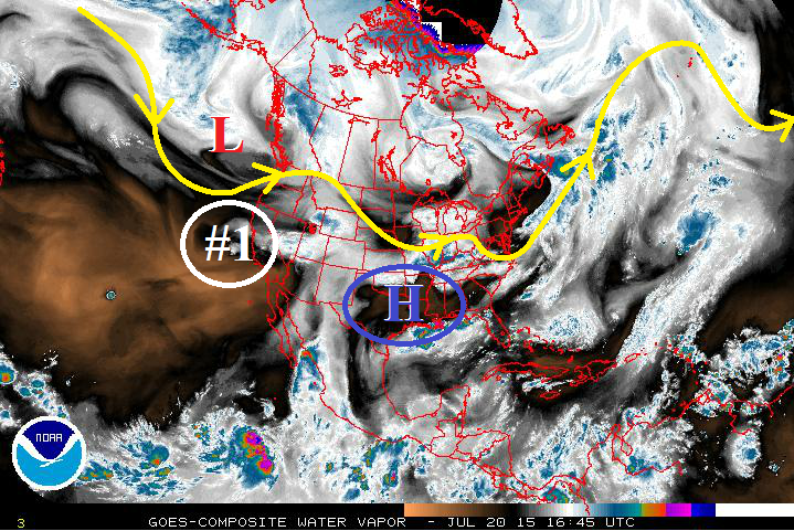
- Remnants of Hurricane Dolores (circled in white, #1) will keep Colorado sufficiently moist through Tuesday, with moisture waning as we move through Wednesday and into Thursday. The upper-level ridge over the south-central US (circled in blue) will continue to retrograde westward, cutting off the moist, southwest flow and drying out Colorado through Saturday with very little precipitation expected.
- Event #2: Sunday (7-26) through Friday (07-31)
- Event #2 is still gathering itself over the Bering Sea, so it is not quite in the view of our water vapor imagery below. This upper-level trough is forecast to begin working down the west coast of Canada on Friday, bringing southwest, monsoonal flow back to Colorado by late Saturday/early Sunday as it forces the upper-level ridge to the east, once again. This will provide an extended wet period (through Friday the 31st) before the main trough slides north and east of Colorado and the upper-level ridge retrogrades and regains its dominance over our weather.
Event #1: Tuesday (07-21) and Wednesday (07-22)
Elevated Flood Threat, Mainly for Burn Scars, Urban Areas, and Unstable Terrain as Remnants of Dolores Move Overhead
Remnants of Hurricane Dolores will keep Colorado sufficiently moist through Tuesday, with moisture waning as we move through Wednesday and into Thursday. The most active day will be Tuesday thanks to the presence of deeper moisture, a passing weak disturbance, and greater instability as compared to Wednesday. Three-fourths or more of the total rainfall forecast for this two-day event will fall on Tuesday.

Event #2: Sunday (7-26) through Friday (07-31)
Elevated Flood Threat as Upper-Low and Monsoonal Surge Create an Extended Wet Period
Southwest, monsoonal flow will return to Colorado on Friday the 18th as an upper-level trough begins to work down the west coast of Canada, forcing the upper-level ridge to the east, once again. This extended cool, wet period will last for several days before the main trough moves north and east of Colorado and the upper-level ridge cuts off the monsoonal flow.