FTO 08-13-2015: Two More Elevated Flood Threats, But Then The First Signs Of Fall?

Issue Date: 8/13/2015
Issue Time: 11:20AM
Valid Dates: 8/14 – 8/28

threat_timeline.20150813A BRIEF BLURB ON CLIMATOLOGY

Climatologically speaking, August is a transition month for most of Colorado. Over the course of the month, our state goes from seeing almost daily thunderstorm activity (especially over the higher terrain) to the slightly cooler and much drier weather that signals the start of fall. Comparing historical average August and September rainfall at a few locations generally emphasizes the point above:

aug_sept_precip
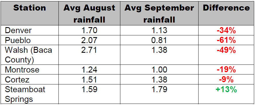
Almost all lower-elevation locations experience steep drops in precipitation from August to September. However, this is not necessarily the case for higher elevation locations (example: Steamboat Springs) where fall cold fronts can cause ample precipitation due to persistent upslope flow.

OVERVIEW

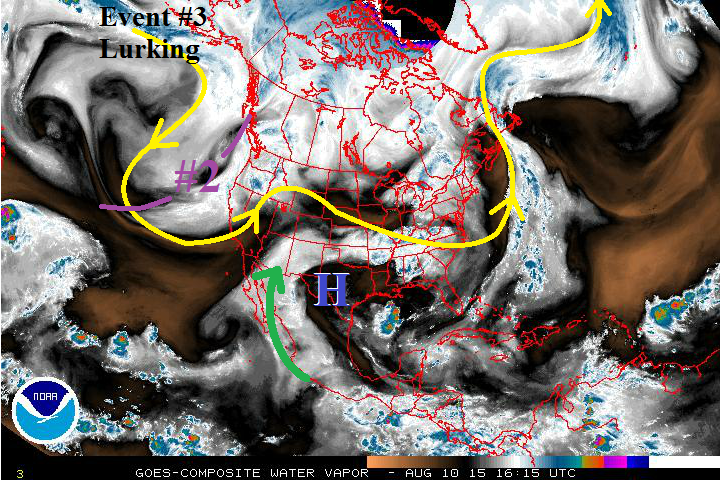
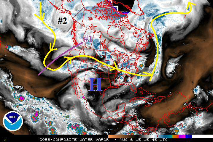
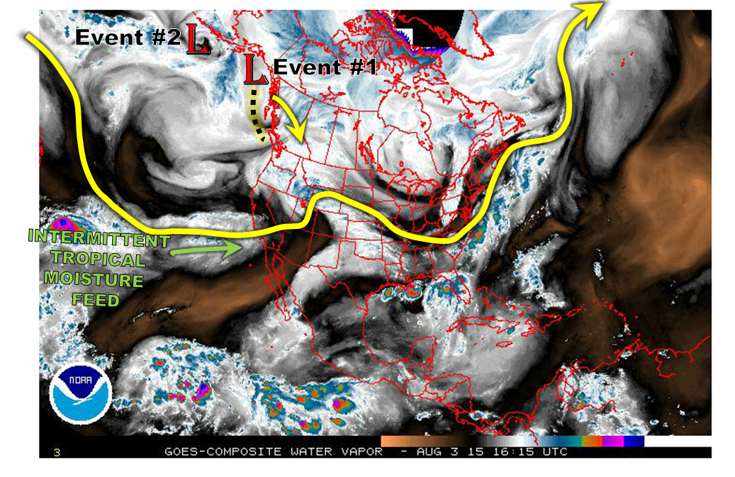
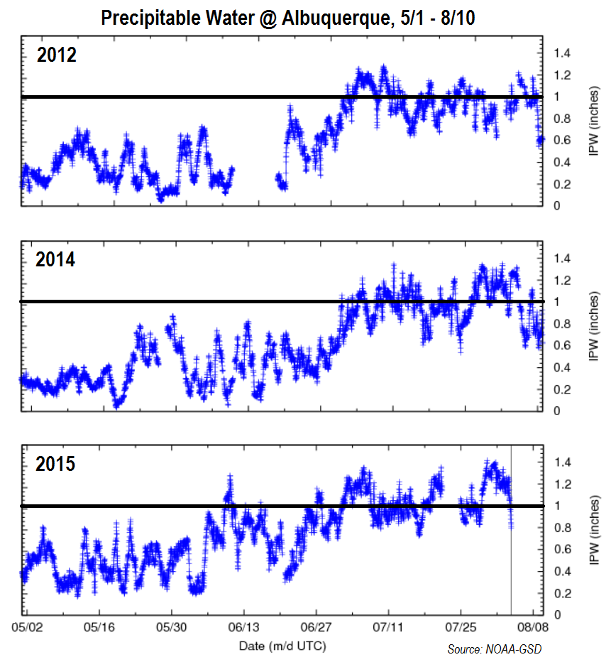
For this Flood Threat Outlook, we see a transition in store for our weather. Let us first investigate what today’s weather map shows. As seen in the water vapor image, below, there are some features that we have seen in the last few weeks. Colorado is sitting under a stout upper-level ridge. However, very high residual moisture implies that rainfall chances will not be completely suppressed. A moderately moist monsoonal feed continues to the west of Colorado. However, we do not expect to see significant moisture transport into our state over the next week. This implies that rainfall chances will hinge strongly on the availability of residual moisture. Over the next five to seven days, this will not be a problem (precipitable water values are expected to stay well above climatology through next week).

watervapor_20150813
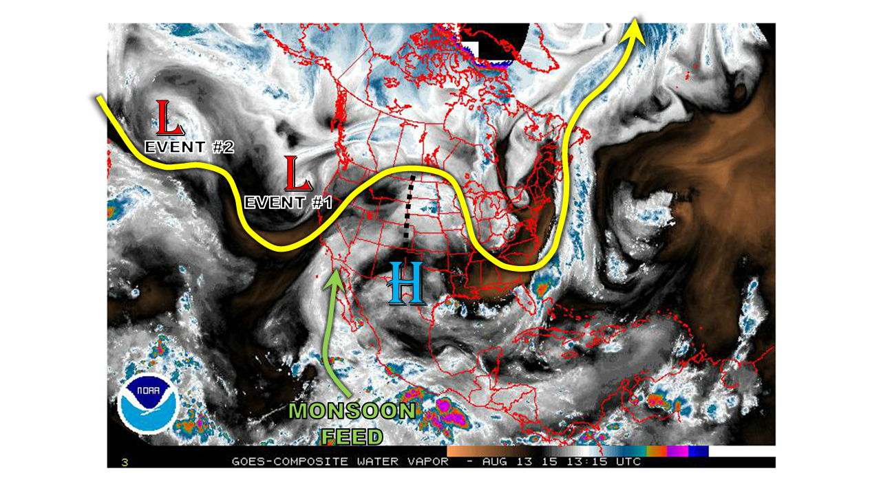
Next, we see two low-pressure disturbances located over the Central and Eastern Pacific. Each of these will, at varying speeds, move eastward towards Colorado over the next week or so. Each disturbance is expected to bring with it a Pacific-origin cool front that will elevate rainfall chances. However, with little to no monsoonal support, the majority of the rainfall is expected to stay east of the Divide. After the passage of the second system (mid next week), there are indications of much cooler weather for the Northern Plains and Rockies. It is not clear how far south this cool weather will penetrate, but at the very least, it should result in substantial drying of the atmosphere and thus, heavy rainfall chances.

Now getting to the specifics, we anticipate two precipitation Events over the period covered by this Flood Threat Outlook. Each of these will bring with it an Elevated flood threat. Let’s look at the details of each Event:

Event #1: Friday (8/14) through Sunday (8/16)

An Elevated flood threat for the Front Range and eastern Plains

Upslope flow will develop on Friday and persist through Sunday as a low pressure brings a cool front southward across the eastern Plains of Colorado. On Friday, most activity will be limited to the higher terrain with rainfall amounts up to 1 inch possible. On Saturday, activity will spread into the Northeast Plains, while Sunday activity will focus on the Palmer Ridge and Southeast Plains. In total rainfall totals up to 2.5 inches will be possible, especially over the Palmer Ridge where areas will likely receive a heavy rainfall threat on multiple days. Due to the atmospheric dynamics, we expect one round of storms each day, which will limit the overall flood threat.


Legend

Event #2: Tuesday (8/18) through Thursday (8/20)

An Elevated flood threat for the eastern Plains

Another low pressure system will dive southeastward and enter the North American coast somewhere between California and Washington. The farther southward positioning of this system is more conducive to a heavy rainfall threat, compared to Event #1. However, the system is expected to move very rapidly, which will put a cap on the overall flood threat. Nonetheless, we expect two to possibly three days of Elevated flood threats as the system crosses over Colorado. Daily storm activity will yield up to 1.5 inches of rainfall on any given day. The Northeast Plains will likely have highest overall rain totals due to access to higher moisture content. There is some uncertainty as to the system’s speed so it is possible that Thursday will be completely dry. There is also some indication that this system will some substantially drier air, which could limit the heavy rainfall chances, especially over and west of the Continental Divide.


Legend

FTO 08-10-2015: Three Events, Two Elevated Flood Threats

Issue Date: 8/10/2015
Issue Time: 1:46 PM

Threat_Timeline_20150810

Another FTO, another discussion on the active atmosphere that continues to feed disturbances and moisture into Colorado. There are three events during this 15-day period, with the first two labeled “Elevated Flood Threats.” Event #3 earns the label “No Apparent Flood Threat” as there are still too many uncertainties to nail down, i.e., the exact track of the upper-level low, associated disturbances, and available moisture.

WV_20150810

Event #1: Tuesday (8-11-2013) and Wednesday (8-12-2015)

Elevated Flood Threat as Upper-Level High Stubbornly Holds on to Moisture

**If you read the FTO from Thursday (08-06-2015), you will notice that what was referred to then as Event #1 has now been split into Events #1 and #2 for this FTO edition.**

Event #1 is associated with the location of the upper-level High (blue “H” on water vapor image) and the monsoonal moisture (green arrow) that it is pulling into Colorado. As the high builds westward, it will keep Colorado under a fairly deep moisture plume with precipitable water values running above average through Wednesday for most locations. Deep moisture, and a couple of mid-/upper-level disturbances embedded in the southwest flow, will allow for any strong thunderstorms to hold heavy rain potential, especially across southern Colorado. By Thursday, the atmosphere will dry out a bit, even though the upper ridge will still be overhead. Isolated diurnal showers and thunderstorms will still be present for Thursday and Friday, but the flood threat looks to come to an end after Wednesday. Stay tuned to upcoming Flood Threat Bulletin’s for up-to-date information.

Legend

Event #2: Saturday (8-15-2015) and Sunday (8-16-2015)

Elevated Flood Threat as Upper-Level Low Moves across Northern Rockies

The upper-level low will finally get tired of meandering along the west coast and become transient, moving across the Northern Rockies during this time frame. Large-scale lift associated with this low will reach across Colorado, providing upper-level support for scattered showers and thunderstorms. On Sunday, the passage of the upper low will force a cool front through Eastern Colorado. In the wake of this front, during Sunday afternoon and evening, more widespread thunderstorms are expected for the eastern mountains and plains.

Legend

Event #3: Thursday (8-20-2015) through Sunday (8-23-2015)

No Apparent Flood Threat as Details are Still Emerging

Event #3 is currently lurking over the Northern Pacific Ocean, and details will emerge over the coming days. Right now, the storm track appears to be much the same as that taken by Event #2, so a repeat could be on tap. Stay tuned to upcoming FTO’s for more information.

FTO 08-06-2015: Two Elevated Flood Threats on the Horizon

Issue Date: 8/06/2015
Issue Time: 1:00 PM

Threat_Timeline_20150806

Mother Nature has given us a fairly active summer season, and the next 15 days look to be no different. Two main events show up in this Flood Threat Outlook period, both characterized by upper-level lows pushing the upper-level ridge to the east and allowing monsoonal moisture to return to Colorado. The first event will be quick and transient, whereas the second event will be a longer duration event. Details on each can be found in the individual event discussions below.

WV_20150806

Often in the Flood Threat Outlook discussions we have mentioned that this season has been “active,” and the image below will help show that. The 90-day average Outgoing Longwave Radiation product shows the radiance of the atmosphere, as seen by satellites, for the time period of May 7th through August 4th. Negative values imply cloudiness, while positive values generally imply clear skies. Note that there is a connection from the blue and purple colors close to the equator all the way to the southwestern U.S. This implies copious amounts of subtropical moisture being ingested into disturbances, and fairly often, with a 90-day average negative value into the southwestern US and Colorado.

90Day_OLR

Event #1: Friday (08-07-2015) and Saturday (08-08-2015)

Elevated Flood Threat from a Surge of Monsoonal Moisture

As the parent upper-level low slides eastward across the US/Canadian border, the trailing trough will move eastward, as well. The trough will force the upper-level ridge currently centered over eastern NM/western TX to shift to the east, bringing the next surge of monsoonal moisture to Colorado. Sufficient moisture and instability, along with a cool frontal passage, on Friday will bring the potential for a few strong-to-severe storms across the Urban Corridor, Palmer Ridge, Northeast Plains, and Southeast Plains regions, with the best chances over the Northeast Plains and Palmer Ridge. Moisture will dry out from north to south as the upper-level ridge shifts back westward and cuts off the flow of subtropical moisture for Sunday, but scattered diurnal showers and thunderstorms will continue across the southern half of Colorado.

Legend

Event #2: Monday (8-10-2013) through Saturday (8-15-2015)

Elevated Flood Threat as Slow-Moving Upper-Level Trough Brings Extended Wet Period

At the beginning of this event period, residual moisture under the building upper-level ridge will keep diurnal showers and thunderstorms active across mainly the southern half of Colorado through Monday and Tuesday. By Wednesday, the approach of an upper-level low will shift the ridge back to the east, bringing monsoonal moisture back to Colorado. Mid-/upper-level disturbances will accompany this moist flow, and locally heavy rainfall will be a concern from thunderstorms. Stay tuned for Monday’s FTB and FTO for more details on this upcoming event.

Legend

FTO 08-03-2015: Monsoon Moisture Pulses + Cool Fronts = Active Weather

Issue Date: 8/3/2015
Issue Time: 2:30PM
Valid Dates: August 4 – August 18

threat_timeline.20150803Mother Nature is not taking her foot off the gas pedal, at least when it comes to the continued prospects of active weather across Colorado. Two things are particularly noteworthy in this afternoon’s snapshot of the atmosphere, shown below in the water vapor image. First, we see two low-pressure disturbances in the Gulf of Alaska. Interestingly, these disturbances are somewhat solitary, in the sense that they are not strongly attached to any significant steering winds. The end result is that their movement will be very slow. Ultimately, both of these features are anticipated to influence our weather over the time period covered by this Flood Threat Outlook.

watervapor_20150803Second, we continue to see pulses of tropical moisture being fed into the southwest United States. Of course, this is quite typical of late summertime due to the monsoonal circulation. However, from a moisture supply perspective, this monsoon has been quite an active one thus far. Below we show how precipitable water (PW) has fared thus far season in Albuquerque, NM. The reason we chose a site in New Mexico is because it is a good proxy for what is entering Colorado from the monsoon moisture flow. We also show a comparison with 2014 (a +/- typical year) and 2012 (a drought year). There are a few things worth noting:

  • This year Albuquerque surpassed the 1 inch PW threshold on June 10th. This is very early, as note how it took until July 1st in both 2012 and 2014 for that value to be exceeded.
  • Note that when PW exceeds 1 inch in Albuquerque, it typically does not stay at that level very long (1-2 days). However, this year there have been 3-5 day stretches where PW has maintained at 1 inch or greater, with the latest period coming over the past few days.

These findings reiterate how incredibly moist this summer has been. Of course, moisture is only a proxy for actual rainfall. But a particularly good proxy in Colorado.

ABQ_ipw_comparison

Back to the forecast, over the course of the next 15 days, we see two time periods with heavy rainfall potential. Both of these Events are classified with an Elevated flood threat. Let’s look at the details of each Event:

Event #1: Thursday (8/6) through Saturday (8/8)

An Elevated flood threat, mainly east of the Divide

The Pacific disturbance will slowly trek from the Gulf of Alaska and impact Colorado by later next week. As this disturbance will likely be coming in from the west/northwest, it appears that the monsoonal connection may be limited. However, this is somewhat uncertain, especially given the tendency for models to underestimate the monsoon feed. We anticipate that the Northeast Plains will be under the highest threat for heavy rainfall as a cool front makes its way down the east face of the Rockies, promoting easterly upslope flow. The cool front will have the opportunity to sag all the way southward through the state, which will provide for rainfall chances even in the Southeast Plains. In additional to the rainfall threat, since this disturbance will be accompanied by jet stream dynamics, hail and strong winds may be possible especially on Thursday 8/6.


Legend

Event #2: Tuesday (8/11) through Thursday (8/13)

An Elevated flood threat east of the Divide

After a several day break from Event #1, the polar jet stream will remain active as the subtropical high is anticipated to move west of Colorado. With the state being in a northwest steering flow, it will be areas east of the Divide that will have the greatest heavy rainfall chance. At least one cool front, originating in the northeast Pacific Ocean, may come down the Northeast and Southeast Plains provide several afternoons of thunderstorm activity. In particular, the Palmer Ridge may see the highest rainfall values due to its ability to temporarily slow down frontal passages. As with Event #1, this event should be supported by a moderate to strong jet stream, which will lead to the threat of gusty winds and hail in addition to the heavy rainfall. However, despite the potential for isolated flash flooding, the good news is that northwest flow events are typically NOT conducive for major flooding in Colorado. It is also worth noting that there are indications of a fall-like cool front to impact the state towards the end of the forecast period. It is far early to speculate whether this will come to fruition, but certainly a reminder that summer’s days are numbered.


Legend