Issue Date: 8/06/2015
Issue Time: 1:00 PM

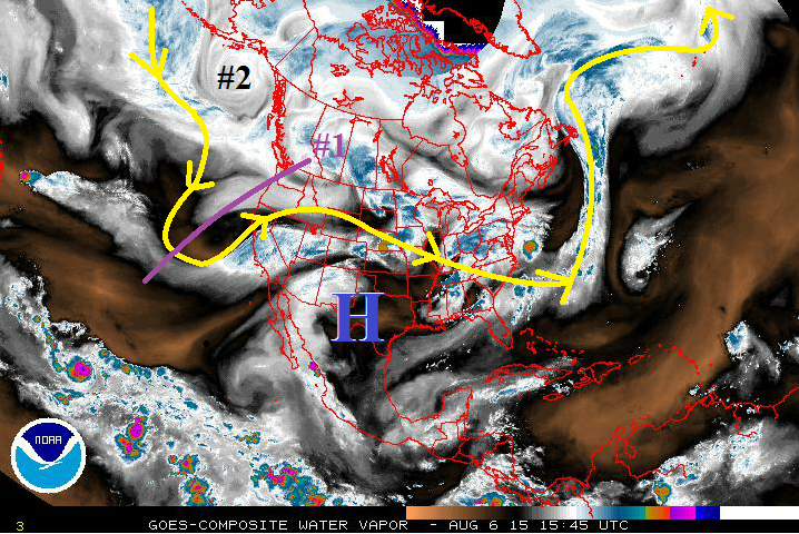
Mother Nature has given us a fairly active summer season, and the next 15 days look to be no different. Two main events show up in this Flood Threat Outlook period, both characterized by upper-level lows pushing the upper-level ridge to the east and allowing monsoonal moisture to return to Colorado. The first event will be quick and transient, whereas the second event will be a longer duration event. Details on each can be found in the individual event discussions below.
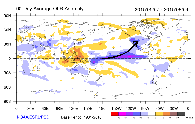
Often in the Flood Threat Outlook discussions we have mentioned that this season has been “active,” and the image below will help show that. The 90-day average Outgoing Longwave Radiation product shows the radiance of the atmosphere, as seen by satellites, for the time period of May 7th through August 4th. Negative values imply cloudiness, while positive values generally imply clear skies. Note that there is a connection from the blue and purple colors close to the equator all the way to the southwestern U.S. This implies copious amounts of subtropical moisture being ingested into disturbances, and fairly often, with a 90-day average negative value into the southwestern US and Colorado.
Event #1: Friday (08-07-2015) and Saturday (08-08-2015)
Elevated Flood Threat from a Surge of Monsoonal Moisture
As the parent upper-level low slides eastward across the US/Canadian border, the trailing trough will move eastward, as well. The trough will force the upper-level ridge currently centered over eastern NM/western TX to shift to the east, bringing the next surge of monsoonal moisture to Colorado. Sufficient moisture and instability, along with a cool frontal passage, on Friday will bring the potential for a few strong-to-severe storms across the Urban Corridor, Palmer Ridge, Northeast Plains, and Southeast Plains regions, with the best chances over the Northeast Plains and Palmer Ridge. Moisture will dry out from north to south as the upper-level ridge shifts back westward and cuts off the flow of subtropical moisture for Sunday, but scattered diurnal showers and thunderstorms will continue across the southern half of Colorado.

Event #2: Monday (8-10-2013) through Saturday (8-15-2015)
Elevated Flood Threat as Slow-Moving Upper-Level Trough Brings Extended Wet Period
At the beginning of this event period, residual moisture under the building upper-level ridge will keep diurnal showers and thunderstorms active across mainly the southern half of Colorado through Monday and Tuesday. By Wednesday, the approach of an upper-level low will shift the ridge back to the east, bringing monsoonal moisture back to Colorado. Mid-/upper-level disturbances will accompany this moist flow, and locally heavy rainfall will be a concern from thunderstorms. Stay tuned for Monday’s FTB and FTO for more details on this upcoming event.