Issue Date: 8/3/2015
Issue Time: 2:30PM
Valid Dates: August 4 – August 18
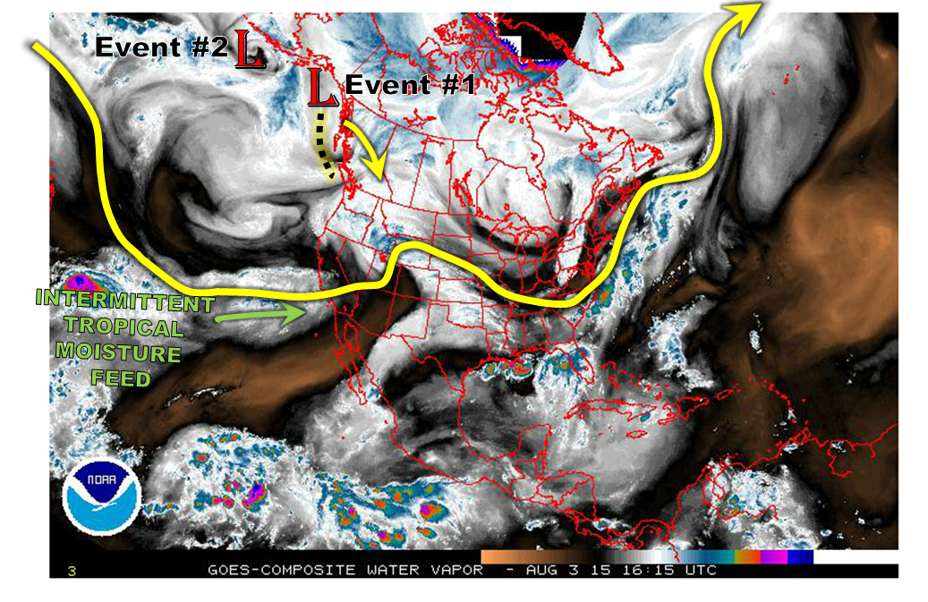
 Mother Nature is not taking her foot off the gas pedal, at least when it comes to the continued prospects of active weather across Colorado. Two things are particularly noteworthy in this afternoon’s snapshot of the atmosphere, shown below in the water vapor image. First, we see two low-pressure disturbances in the Gulf of Alaska. Interestingly, these disturbances are somewhat solitary, in the sense that they are not strongly attached to any significant steering winds. The end result is that their movement will be very slow. Ultimately, both of these features are anticipated to influence our weather over the time period covered by this Flood Threat Outlook.
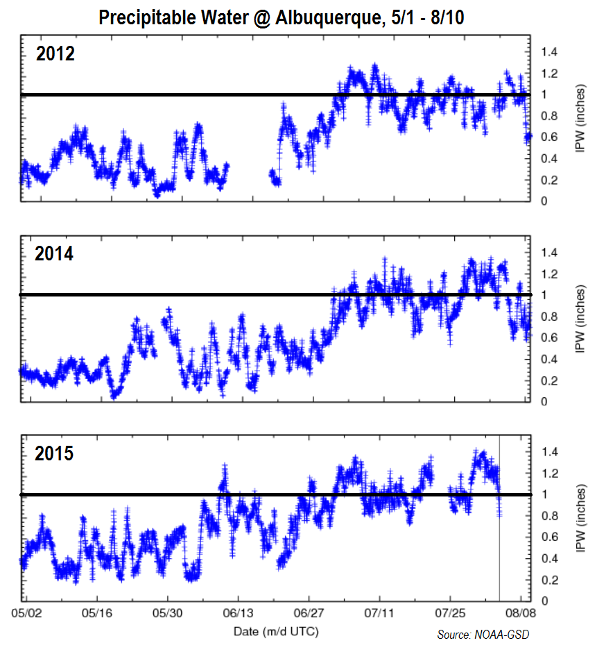
 Second, we continue to see pulses of tropical moisture being fed into the southwest United States. Of course, this is quite typical of late summertime due to the monsoonal circulation. However, from a moisture supply perspective, this monsoon has been quite an active one thus far. Below we show how precipitable water (PW) has fared thus far season in Albuquerque, NM. The reason we chose a site in New Mexico is because it is a good proxy for what is entering Colorado from the monsoon moisture flow. We also show a comparison with 2014 (a +/- typical year) and 2012 (a drought year). There are a few things worth noting:
- This year Albuquerque surpassed the 1 inch PW threshold on June 10th. This is very early, as note how it took until July 1st in both 2012 and 2014 for that value to be exceeded.
- Note that when PW exceeds 1 inch in Albuquerque, it typically does not stay at that level very long (1-2 days). However, this year there have been 3-5 day stretches where PW has maintained at 1 inch or greater, with the latest period coming over the past few days.
These findings reiterate how incredibly moist this summer has been. Of course, moisture is only a proxy for actual rainfall. But a particularly good proxy in Colorado.
Back to the forecast, over the course of the next 15 days, we see two time periods with heavy rainfall potential. Both of these Events are classified with an Elevated flood threat. Let’s look at the details of each Event:
Event #1: Thursday (8/6) through Saturday (8/8)
An Elevated flood threat, mainly east of the Divide
The Pacific disturbance will slowly trek from the Gulf of Alaska and impact Colorado by later next week. As this disturbance will likely be coming in from the west/northwest, it appears that the monsoonal connection may be limited. However, this is somewhat uncertain, especially given the tendency for models to underestimate the monsoon feed. We anticipate that the Northeast Plains will be under the highest threat for heavy rainfall as a cool front makes its way down the east face of the Rockies, promoting easterly upslope flow. The cool front will have the opportunity to sag all the way southward through the state, which will provide for rainfall chances even in the Southeast Plains. In additional to the rainfall threat, since this disturbance will be accompanied by jet stream dynamics, hail and strong winds may be possible especially on Thursday 8/6.

Event #2: Tuesday (8/11) through Thursday (8/13)
An Elevated flood threat east of the Divide
After a several day break from Event #1, the polar jet stream will remain active as the subtropical high is anticipated to move west of Colorado. With the state being in a northwest steering flow, it will be areas east of the Divide that will have the greatest heavy rainfall chance. At least one cool front, originating in the northeast Pacific Ocean, may come down the Northeast and Southeast Plains provide several afternoons of thunderstorm activity. In particular, the Palmer Ridge may see the highest rainfall values due to its ability to temporarily slow down frontal passages. As with Event #1, this event should be supported by a moderate to strong jet stream, which will lead to the threat of gusty winds and hail in addition to the heavy rainfall. However, despite the potential for isolated flash flooding, the good news is that northwest flow events are typically NOT conducive for major flooding in Colorado. It is also worth noting that there are indications of a fall-like cool front to impact the state towards the end of the forecast period. It is far early to speculate whether this will come to fruition, but certainly a reminder that summer’s days are numbered.