FTO 08-27-2015: Three Events, No Apparent Flood Threats

Issue Date: 8/27/2015
Issue Time: 12:35 PM

Threat_Timeline_20150827

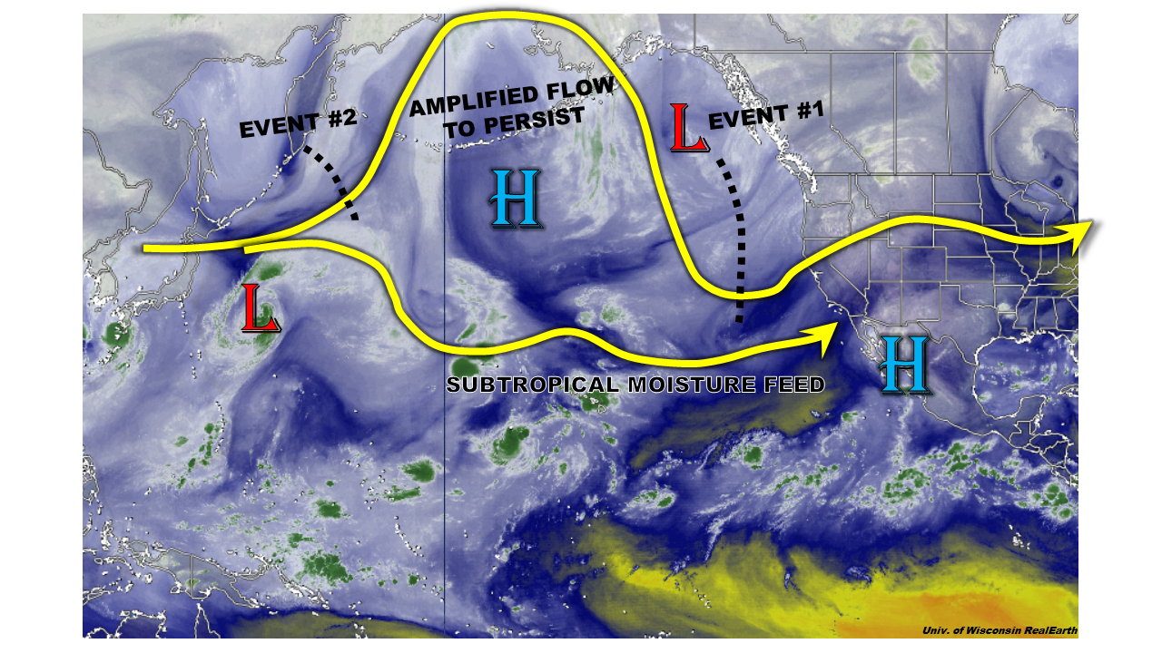
There are 5 main features to pick out of the water vapor image below: Tropical Storm Erika in the Atlantic, Tropical Storm Jimena (right) and Hurricane Ignacio (left) in the Pacific, high pressure ridge over the central/western US, and the low pressure trough off the west coast of the US and Canada. Tropical Storm Erika does not mean much to our forecast, but it will be interesting to watch over the coming days with regards to its track, intensity, and longevity. Jimena and Ignacio will continue to move westward further into the Pacific, and are also without impact to Colorado.

WV_08272015

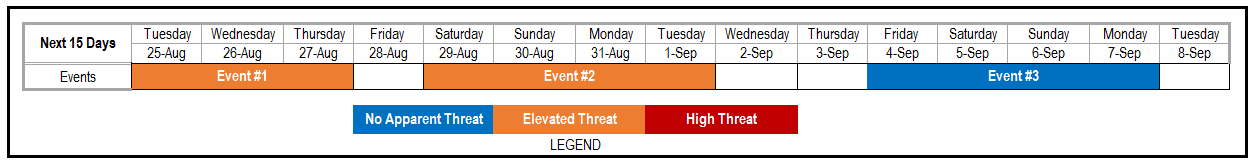
The high pressure ridge and low pressure trough, and how they interact with each other, will be the main story of this FTO period. As hard as the low pressure trough tries, the high pressure ridge is not ready to give up ground. As those two systems duke it out, monsoonal moisture will come and go, along with associated disturbances. The low pressure trough will also eject a few shortwave troughs through the forecast period, but the best broad-scale support for thunderstorms will likely be too far north to really mean a prolonged/elevated flood threat for Colorado. In the event discussions below, I have highlighted 3 “event” periods, none of which provide an apparent flood threat. In a weather regime such as this, the daily Flood Threat Bulletin’s will be crucial because the amount of moisture/instability/support will fluctuate daily. Stay tuned.

Event #1: Saturday (08-29-2015) through Tuesday (09-01-2015)

No Apparent Flood Threat from mostly “Garden-variety” Thunderstorms

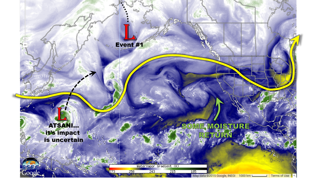
Weak south/southwesterly flow aloft will return as the ridge axis gets pushed east of Colorado by the upper-level trough. This will bring some moisture back into Colorado, providing an uptick in precipitation over and adjacent to the mountains. Low-level moisture east of the mountains will be a bit on the low side, so most storms will be garden variety with brief light-to-moderate rainfall. Over the mountains, moisture will be better overall, so locally heavy rainfall will be possible. At this time, precipitation totals from the 4-day event are not that spectacular, with most areas receiving a half-inch or less. No flood threat designation is warranted at this time.

Legend

Event #2: Thursday (09-03-2015) through Sunday(09-06-2015)

No Apparent Flood Threat with a Near-Repeat of Event #1

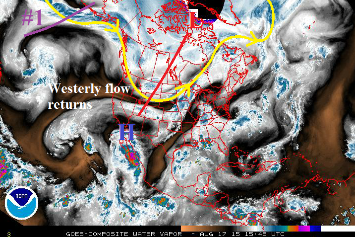
Nearly a repeat of Event #1, the upper-level trough off the west coast forces the ridge axis back to the east, bringing south/southwesterly flow aloft back to Colorado. This will bring an increase in moisture, once again, though how deep the moisture will be is to be determined. The upper-level trough will eject another shortwave during the second half of the period, but the best support for thunderstorms will remain north and east of Colorado. With the amount of moisture present still coming into focus, no flood threat designation is warranted at this time. The precipitation map below is what current observations/analysis suggest, and is subject to revision for the next FTO. Stay tuned.

Legend

Event #3: Tuesday (09-08-2015) and Wednesday (09-09-2015)

No Apparent Flood Threat as This Event is Still Coming into Focus

After a short-lull, Event #3 will be a quick-hitter. The upper-level trough that was anchored along the West Coast looks like it will finally get its way, pushing to the east in a fairly quick fashion. Following this event, it appears things may be quiet through the following weekend. Details will come into focus over the coming days, so check back in the next edition of the FTO on Monday.

FTO 08-24-2015: Flood Threat Increases As Very Active Period Is In Store

Issue Date: 8/24/2015
Issue Time: 12:15PM
Valid dates: August 25th – September 8th

OVERVIEW

threat_timeline.20150824

The relatively dry and pleasant weather period that Colorado has experienced over the past week or two may be coming to an abrupt end. As the water vapor image shows, below, a very amplified flow is seen across the Central Pacific. This is the region that we typically look to in order determine what is in store for our state. As advertised last Thursday, even though former Super Typhoon Atsani will not even make it east of the Dateline, its recent re-curve to the north will help support such an amplified flow pattern for the next 15 day period. Such a pattern will feature a persistent large scale-trough aligned almost parallel with the North American west coast. Though this kind of position is a touch too far west of the typical setup for heavy rainfall in Colorado, a very long moisture fetch will sustain high moisture content to make it into the southwest United States. Thus, we expect a prolonged threat of heavy rainfall across most of the state. However, it is important to note that this threat will be of a localized scale and we do not foresee widespread flooding concerns at this time.

watervapor_20150824

Looking into the specific, we anticipate three separate precipitation periods across the state. The first two are given Elevated flood threats, while the third event does not currently have an identifiable flood threat but will likely generate some precipitation. Please stay tuned to our Flood Threat Outlook updates during this active period. Without further ado, the specifics of each event:

Event #1: Tuesday (8/25) through Thursday (8/27)

An Elevated flood threat statewide

A multi-day flood threat will exist as a monsoon surge will combine with at least one small disturbance, which will be ejected from the west coast trough. The impacts will start in the southwest on Tuesday where a round of afternoon and evening thunderstorms could produce up to 1.5 inches of rainfall. On Wednesday, as the disturbance moves northeast the storm activity will accompany it into the Central Mountains. A secondary wave of activity will be possible over the Front Range and Northeast Plains. Rainfall amounts up to 1.5 inches will be possible. Finally, as the disturbances “rounds the ridge”, a final wave of thunderstorm activity will be possible over the Southeast Plains, where up to 1.5 inches of rainfall will be possible. All in all, we do not expect widespread flooding, but certainly a lot of storm activity that could bring an isolated flash flood threat.


Legend

Event #2: Saturday (8/29) through Tuesday (9/1)

Continued Elevated flood threat statewide

After a very short break where the high-pressure ridge will briefly re-exert dominance, more active weather is expected starting Saturday 8/29. The setup will be very similar to Event #1: additional smaller disturbances will likely come off the trough. However, the trough itself is expected to stay relatively stationary along the west coast. A multi-day period of active weather looks likely with storms across the higher terrain over and west of the Continental Divide initially, then spreading eastward. Up to 1.5 inches of rainfall looks possible across favored higher-terrain areas, as well as areas over the Northeast and Southeast Plains and disturbances move off the mountains. The exact placement of the heaviest rainfall east of the Divide may change with new guidance, so stay tuned to our Thursday Flood Threat Outlook update.


Legend

Event #3: Friday (9/4) through Monday (9/7)

No Apparent Flood Threat

The surprisingly persistent west coast trough is expected to stick around through this period. This will provide support periodic disturbances to be sent eastward. Though there is good confidence that rainfall chances will stay elevation, at this time, it is not clear how much subtropical/monsoonal moisture will be available.

FTO 08-20-2015: One Elevated Threat Event As Eyes Are On Atsani

Issue Date: 8/20/2015
Issue Time: 12:30PM
Valid dates: August 21 – September 4

Overview

To those readers that regularly read the Flood Threat Outlook, you are probably aware that we typically show the water vapor image over North America and the central/eastern Pacific Ocean to explore the storm track. Well, today, that just will not do the forecast for the next 15 days enough justice. Instead, we must extend our view all the way to Asia’s east coast (today we are using the University of Wisconsin’s RealEarth application). Now if we look at this extended water vapor imagery, see below, note the strong typhoon southeast of Japan. Meet Super Typhoon Atsani. Atsani has sustained winds of 150 mph, a very low central pressure, and it will start recurving towards the Central Pacific Ocean over the next 24-36 hours. While Atsani will not directly affect Colorado’s weather, it will induce a potentially strong wave train that will likely impact our state for an uncertain amount of time beginning Wednesday of next week.

watervapor_20150820

From now through next Tuesday, we expect typical late summer conditions, with a few rounds of showers and weak thunderstorms possible. However, the total amount of this rainfall will be rather light, up to 0.5 inch, and no flooding is anticipated. Beginning next Wednesday, the recurving of Atsani will setup a domino effect that will allow another low-pressure system (Event #1 in map above) to slowly approach the west coast. Almost all indications are once this disturbance arrives over the west coast, it may not move much. Add to this the return of tropical moisture, and it appears that Colorado will enter a 3+ day period of heavy rain potential that will continue into next weekend. After next weekend, it appears that part of the disturbance responsible for Event #1 will hang back along the west coast. However, with the strength of the monsoonal feed highly uncertain, heavy rainfall is not guaranteed at this time.

Now let’s focus on the details of Event #1 and #2.

Event #1: Friday (8/26) through Saturday (8/29)

An Elevated flood threat statewide

A strong disturbance is expected to stall along the west coast of the United States, putting Colorado in a favorable setup for heavy rainfall. The axis of the disturbance will setup roughly from eastern Washington through southern California. With strong southwesterly flow to its east, daily rounds of thunderstorm activity are expected over and west of the Divide. The climatologically favored regions, including the San Juans, Elk Mountains and Sawatch Range should see a widespread 1.5 to 2 inches of rain through the period. With back-to-back days of rainfall expected, mud flows and debris slides will also join flash flooding as the main threat.

East of the Divide, the setup is more uncertain since upslope flow will be required to produce any sustained heavy rainfall. At this time it appears that Friday may see this kind of setup. This will result in at least one round of heavy rainfall along the entirety of the Front Range. Thereafter, there is disagreement in guidance as to how fast the disturbance will propagate to the east. Thus, Saturday is labeled as “No Apparent Threat” for now.

Legend

Event #2: Tuesday (9/1) through Thursday (9/3)

No Apparent Flood Threat

Part of the Event #1 disturbance is expected to retrograde, or move westward, as the rest of the disturbance moves away. This will continue to support south-southwesterly flow into Colorado. There is currently not enough agreement in guidance to determine if enough monsoonal moisture will remain to cause substantial rainfall during this time. However, continued rainfall chances are likely across the state.

FTO 08-17-2015: No Apparent Flood Threats in the Extended Range

Issue Date: 8/17/2015
Issue Time: 12:37 PM

Threat_Timeline_08172015

Mother Nature appears to finally be giving Colorado a break from the wave train of storms that has kept our weather pattern active for the better part of the summer, and only two events will be discussed in this Flood Threat Outlook. Of those two, both will be labeled as “No Apparent Flood Threat” events at this time. The water vapor imagery below paints a messy picture, but a picture worth dissecting nonetheless. The trough responsible for today’s Moderate Flood Threat in the Flood Threat Bulletin is depicted by the red line stretching across Canada and into the Central/Northern Rockies. Once this trough passes to the north and east of Colorado by tomorrow morning, subsidence will return along with drier, westerly flow. This will limit the amount of showers and thunderstorms, and confine them to mainly the higher terrain through Thursday.

The upper-level trough denoted by the purple line is Event #1. This will pass to the north of Colorado between Friday the 21st and Sunday the 23rd, too far north to bring broad-scale support for thunderstorms to Colorado. After Event #1, westerly flow and drier air will return again ahead of Event #2. High temperatures will climb back to near, or just above, average during this time frame, with highs across the eastern plains reaching into the low-to-mid 90s.

WV_20150817

Event #1: Friday (08-21-2015) through Sunday (08-23-2015)

No Apparent Flood Threat as Main Trough passes too far to the North

The trough denoted in the water vapor imagery will likely skirt along the US/Canada border, providing Colorado with very little, if any, broad-scale support for thunderstorms. The best rain during this period will fall across the southern and central mountains, as well as along the Front Range/Urban Corridor south of I-70. Three-day rainfall totals will be less than 0.75 inches.

Event #2: Saturday (08-29-2015) through Tuesday (09-01-2015)

No Apparent Flood Threat Yet, But Trough with a Taste of Fall Looms

It feels odd to say because it feels like Summer has just begun, but Fall is right around the corner. Event #2 threatens to bring the first taste of Fall in the form of a fairly strong trough. Ahead of the trough, there will be a few days of above average temperatures, and following the trough (and associated cool frontal passage) will be days of below average temperatures. It is too early to determine how much moisture will be available to this system, so a precipitation map is not warranted. At any rate, the best rainfall (relative to the system) will fall across the Front Range, Urban Corridor, Palmer Ridge, and western extents of the Northeast Plains and Southeast Plains. Stay tuned to future FTO’s to get the most up-to-date information.