Issue Date: 8/24/2015
Issue Time: 12:15PM
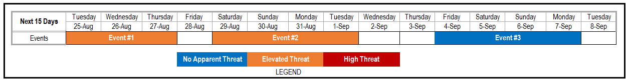
Valid dates: August 25th – September 8th
OVERVIEW
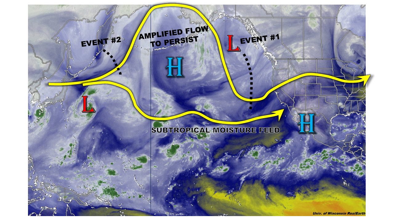
The relatively dry and pleasant weather period that Colorado has experienced over the past week or two may be coming to an abrupt end. As the water vapor image shows, below, a very amplified flow is seen across the Central Pacific. This is the region that we typically look to in order determine what is in store for our state. As advertised last Thursday, even though former Super Typhoon Atsani will not even make it east of the Dateline, its recent re-curve to the north will help support such an amplified flow pattern for the next 15 day period. Such a pattern will feature a persistent large scale-trough aligned almost parallel with the North American west coast. Though this kind of position is a touch too far west of the typical setup for heavy rainfall in Colorado, a very long moisture fetch will sustain high moisture content to make it into the southwest United States. Thus, we expect a prolonged threat of heavy rainfall across most of the state. However, it is important to note that this threat will be of a localized scale and we do not foresee widespread flooding concerns at this time.
Looking into the specific, we anticipate three separate precipitation periods across the state. The first two are given Elevated flood threats, while the third event does not currently have an identifiable flood threat but will likely generate some precipitation. Please stay tuned to our Flood Threat Outlook updates during this active period. Without further ado, the specifics of each event:
Event #1: Tuesday (8/25) through Thursday (8/27)
An Elevated flood threat statewide
A multi-day flood threat will exist as a monsoon surge will combine with at least one small disturbance, which will be ejected from the west coast trough. The impacts will start in the southwest on Tuesday where a round of afternoon and evening thunderstorms could produce up to 1.5 inches of rainfall. On Wednesday, as the disturbance moves northeast the storm activity will accompany it into the Central Mountains. A secondary wave of activity will be possible over the Front Range and Northeast Plains. Rainfall amounts up to 1.5 inches will be possible. Finally, as the disturbances “rounds the ridge”, a final wave of thunderstorm activity will be possible over the Southeast Plains, where up to 1.5 inches of rainfall will be possible. All in all, we do not expect widespread flooding, but certainly a lot of storm activity that could bring an isolated flash flood threat.

Event #2: Saturday (8/29) through Tuesday (9/1)
Continued Elevated flood threat statewide
After a very short break where the high-pressure ridge will briefly re-exert dominance, more active weather is expected starting Saturday 8/29. The setup will be very similar to Event #1: additional smaller disturbances will likely come off the trough. However, the trough itself is expected to stay relatively stationary along the west coast. A multi-day period of active weather looks likely with storms across the higher terrain over and west of the Continental Divide initially, then spreading eastward. Up to 1.5 inches of rainfall looks possible across favored higher-terrain areas, as well as areas over the Northeast and Southeast Plains and disturbances move off the mountains. The exact placement of the heaviest rainfall east of the Divide may change with new guidance, so stay tuned to our Thursday Flood Threat Outlook update.
Event #3: Friday (9/4) through Monday (9/7)
No Apparent Flood Threat
The surprisingly persistent west coast trough is expected to stick around through this period. This will provide support periodic disturbances to be sent eastward. Though there is good confidence that rainfall chances will stay elevation, at this time, it is not clear how much subtropical/monsoonal moisture will be available.