Issue Date: 8/17/2015
Issue Time: 12:37 PM

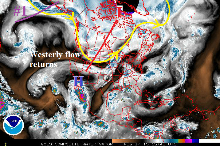
Mother Nature appears to finally be giving Colorado a break from the wave train of storms that has kept our weather pattern active for the better part of the summer, and only two events will be discussed in this Flood Threat Outlook. Of those two, both will be labeled as “No Apparent Flood Threat” events at this time. The water vapor imagery below paints a messy picture, but a picture worth dissecting nonetheless. The trough responsible for today’s Moderate Flood Threat in the Flood Threat Bulletin is depicted by the red line stretching across Canada and into the Central/Northern Rockies. Once this trough passes to the north and east of Colorado by tomorrow morning, subsidence will return along with drier, westerly flow. This will limit the amount of showers and thunderstorms, and confine them to mainly the higher terrain through Thursday.
The upper-level trough denoted by the purple line is Event #1. This will pass to the north of Colorado between Friday the 21st and Sunday the 23rd, too far north to bring broad-scale support for thunderstorms to Colorado. After Event #1, westerly flow and drier air will return again ahead of Event #2. High temperatures will climb back to near, or just above, average during this time frame, with highs across the eastern plains reaching into the low-to-mid 90s.
Event #1: Friday (08-21-2015) through Sunday (08-23-2015)
No Apparent Flood Threat as Main Trough passes too far to the North
The trough denoted in the water vapor imagery will likely skirt along the US/Canada border, providing Colorado with very little, if any, broad-scale support for thunderstorms. The best rain during this period will fall across the southern and central mountains, as well as along the Front Range/Urban Corridor south of I-70. Three-day rainfall totals will be less than 0.75 inches.
Event #2: Saturday (08-29-2015) through Tuesday (09-01-2015)
No Apparent Flood Threat Yet, But Trough with a Taste of Fall Looms
It feels odd to say because it feels like Summer has just begun, but Fall is right around the corner. Event #2 threatens to bring the first taste of Fall in the form of a fairly strong trough. Ahead of the trough, there will be a few days of above average temperatures, and following the trough (and associated cool frontal passage) will be days of below average temperatures. It is too early to determine how much moisture will be available to this system, so a precipitation map is not warranted. At any rate, the best rainfall (relative to the system) will fall across the Front Range, Urban Corridor, Palmer Ridge, and western extents of the Northeast Plains and Southeast Plains. Stay tuned to future FTO’s to get the most up-to-date information.