Issue Date: 8/20/2015
Issue Time: 12:30PM
Valid dates: August 21 – September 4
Overview
To those readers that regularly read the Flood Threat Outlook, you are probably aware that we typically show the water vapor image over North America and the central/eastern Pacific Ocean to explore the storm track. Well, today, that just will not do the forecast for the next 15 days enough justice. Instead, we must extend our view all the way to Asia’s east coast (today we are using the University of Wisconsin’s RealEarth application). Now if we look at this extended water vapor imagery, see below, note the strong typhoon southeast of Japan. Meet Super Typhoon Atsani. Atsani has sustained winds of 150 mph, a very low central pressure, and it will start recurving towards the Central Pacific Ocean over the next 24-36 hours. While Atsani will not directly affect Colorado’s weather, it will induce a potentially strong wave train that will likely impact our state for an uncertain amount of time beginning Wednesday of next week.
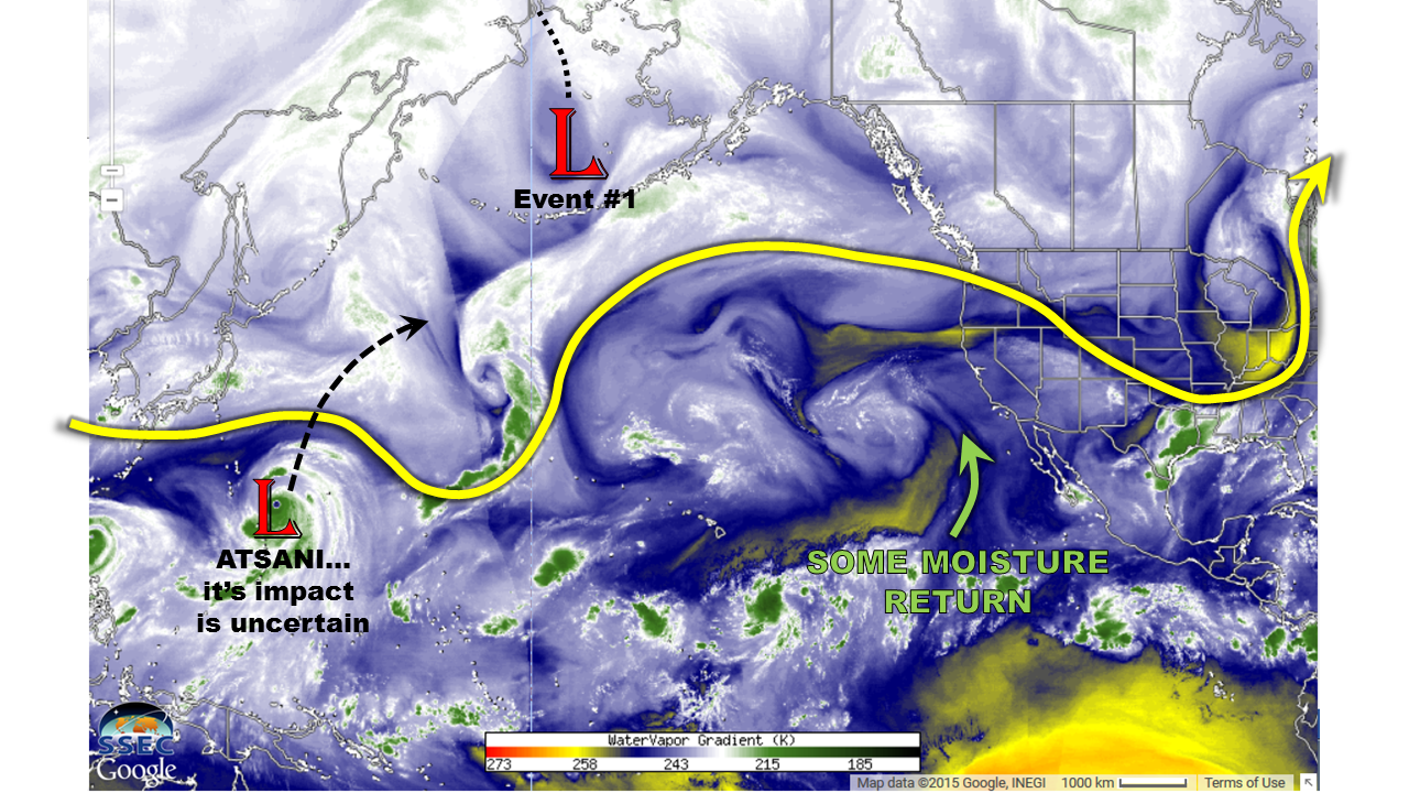
From now through next Tuesday, we expect typical late summer conditions, with a few rounds of showers and weak thunderstorms possible. However, the total amount of this rainfall will be rather light, up to 0.5 inch, and no flooding is anticipated. Beginning next Wednesday, the recurving of Atsani will setup a domino effect that will allow another low-pressure system (Event #1 in map above) to slowly approach the west coast. Almost all indications are once this disturbance arrives over the west coast, it may not move much. Add to this the return of tropical moisture, and it appears that Colorado will enter a 3+ day period of heavy rain potential that will continue into next weekend. After next weekend, it appears that part of the disturbance responsible for Event #1 will hang back along the west coast. However, with the strength of the monsoonal feed highly uncertain, heavy rainfall is not guaranteed at this time.
Now let’s focus on the details of Event #1 and #2.
Event #1: Friday (8/26) through Saturday (8/29)
An Elevated flood threat statewide
A strong disturbance is expected to stall along the west coast of the United States, putting Colorado in a favorable setup for heavy rainfall. The axis of the disturbance will setup roughly from eastern Washington through southern California. With strong southwesterly flow to its east, daily rounds of thunderstorm activity are expected over and west of the Divide. The climatologically favored regions, including the San Juans, Elk Mountains and Sawatch Range should see a widespread 1.5 to 2 inches of rain through the period. With back-to-back days of rainfall expected, mud flows and debris slides will also join flash flooding as the main threat.
East of the Divide, the setup is more uncertain since upslope flow will be required to produce any sustained heavy rainfall. At this time it appears that Friday may see this kind of setup. This will result in at least one round of heavy rainfall along the entirety of the Front Range. Thereafter, there is disagreement in guidance as to how fast the disturbance will propagate to the east. Thus, Saturday is labeled as “No Apparent Threat” for now.
Event #2: Tuesday (9/1) through Thursday (9/3)
No Apparent Flood Threat
Part of the Event #1 disturbance is expected to retrograde, or move westward, as the rest of the disturbance moves away. This will continue to support south-southwesterly flow into Colorado. There is currently not enough agreement in guidance to determine if enough monsoonal moisture will remain to cause substantial rainfall during this time. However, continued rainfall chances are likely across the state.