Issue Date: Thursday, June 23rd, 2022
Issue Time: 3PM MDT
Valid Dates: 6/24 – 7/8
It has certainly been an interesting June so far for Colorado’s weather. And fortunately, the main story continues to center on precipitation chances, as opposed to dryness and wildfire issues that have plagued the state over the past few years and even earlier this spring. To put it briefly, given the moisture we have seen in place, it appears that Colorado (especially the southwest corner) has been somewhat lucky in avoiding flooding thus far into our heavy rainfall season. Of course, we are not complaining, but let us quickly recap why this may have been the case before proceeding with the rest of the Outlook.
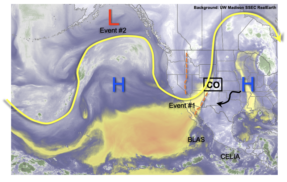
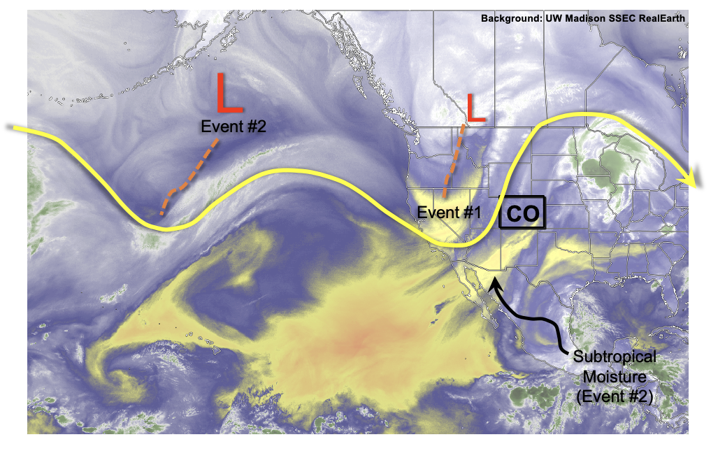
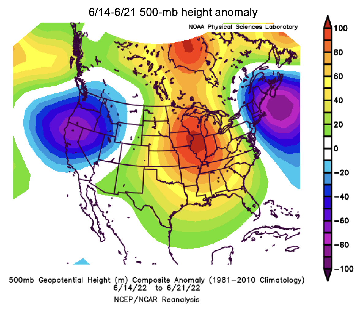
Shown below is the 500-mb height anomaly over the past week or so (although this is quite similar if we expand to include all of June). This essentially shows the pressure anomaly estimated in the middle of the troposphere (roughly 20,000 feet above sea level). The primary feature that we see is the large ridge centered over central North America. With the clockwise circulation around this ridge paired with a modest low-pressure anomaly over the west coast, we deduce that the mid-level flow into Colorado thus far in June has been generally from the south.
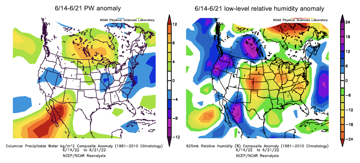
Now, knowing that water vapor generally increases as one moves southward, we can deduce that there has been above average moisture over the southern Four Corners region, right? As shown in the left map, below, this is sort of true. There has definitely been above normal moisture over AZ and NM, but the signal dissipates by the time we get to Colorado. Instead, what we can deduce is that there has been a stronger that normal moisture gradient between Colorado and New Mexico. Accordingly, New Mexico has picked up copious amounts of rain, especially by June standards, whereas Colorado has been only slightly wetter than normal (of course, no complaining about that!). Meanwhile, the below map on the right shows that low-level moisture (a proxy for what is available for fueling thunderstorms) has actually been below normal for most of Colorado! Comparing the two images below, this suggests that the majority of the above normal moisture (as measured by PW) has actually been too high (above the boundary layer) where it is less effective at signaling heavy rainfall potential.
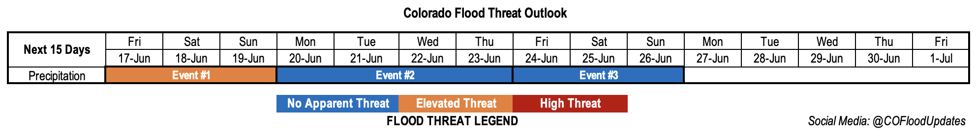
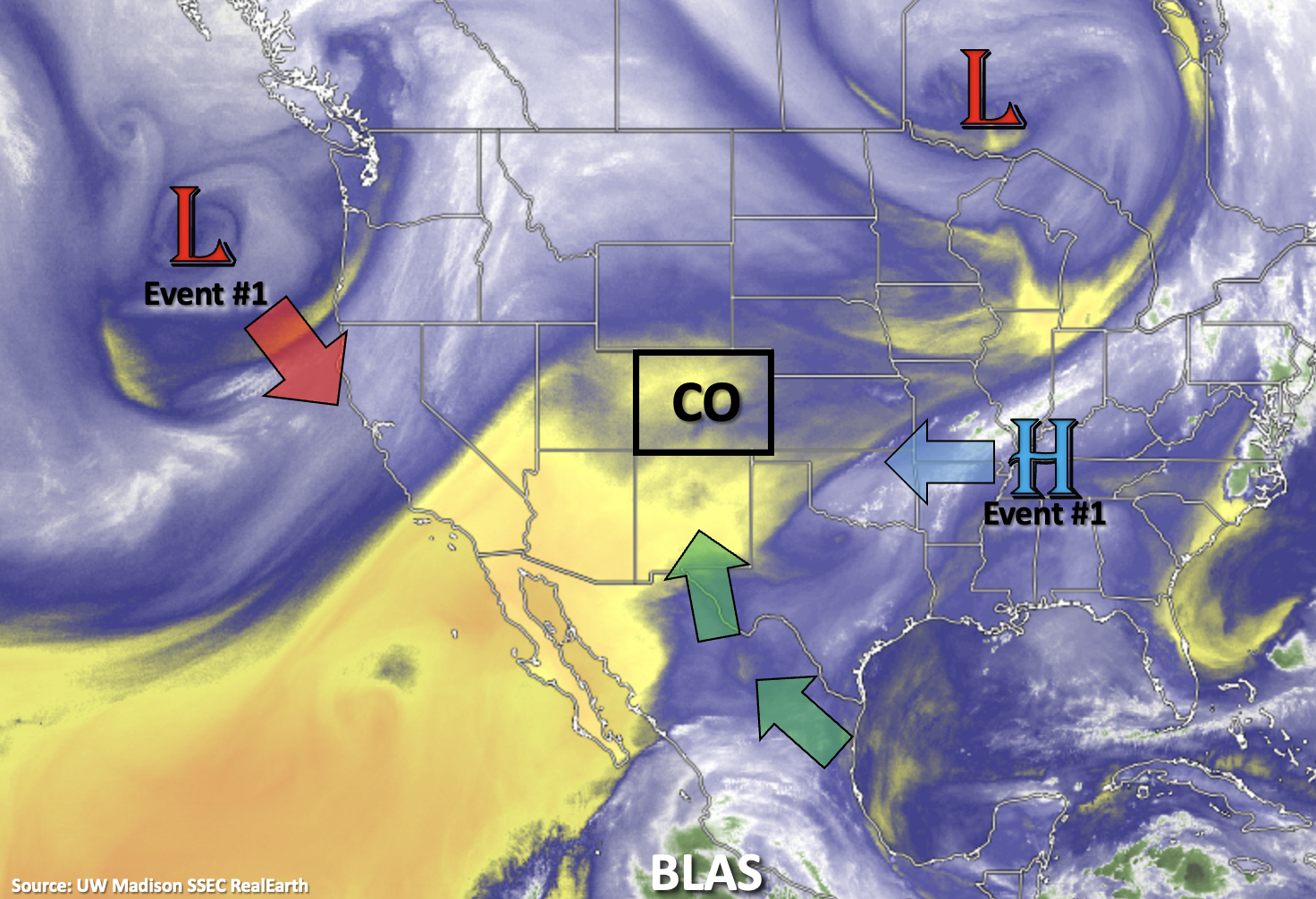
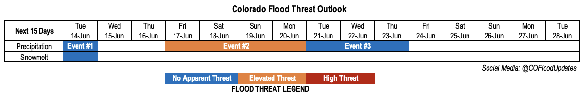
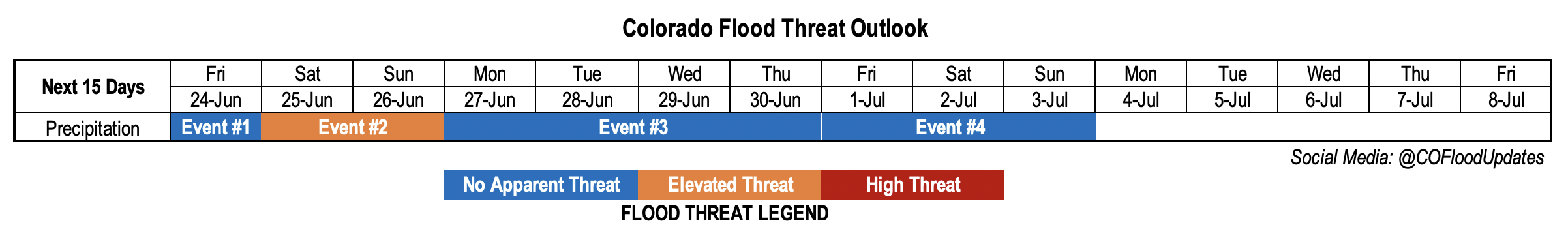
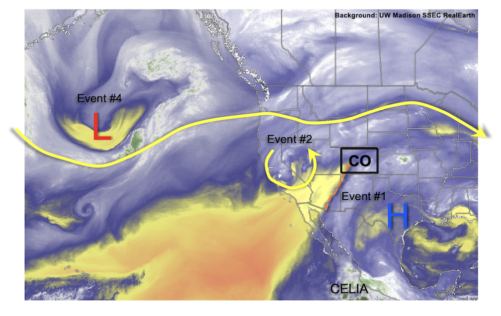
So does any of this have relevance for the current Outlook? In short, yes. Taking a look at this afternoon’s water vapor image, below, we see that the upper-level ridge that has been over the central US has shifted a bit further south. To the west, a cut-off low pressure of modest size and strength is noted over California. Pairing the two together shows that Colorado is again under extensive southerly flow originating in the subtropics/tropics. In fact, there is basically an unabated streamline linking soon-to-be Hurricane Celia all the way to Colorado. Over the next 3-5 days, until the upper-level ridge slowly dissipates and moves westward, Colorado will see continued above normal precipitation chances. Initially, this will be mainly over the western half of the state (Event #1), with limited rainfall intensity. But by Saturday, the approach of a moist Pacific cool front will allow precipitation to overspread most of the state (Event #2). Only considering model QPF at face value, one would think Event #2 could be of serious concern. Yet, a closer look at dynamics instead suggests limited instability both in space and time, instead conveying more of a prolonged, moderate-intensity rainfall for most locations with only a low-end Elevated flood threat anticipated.
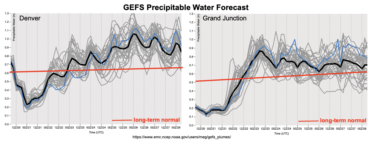
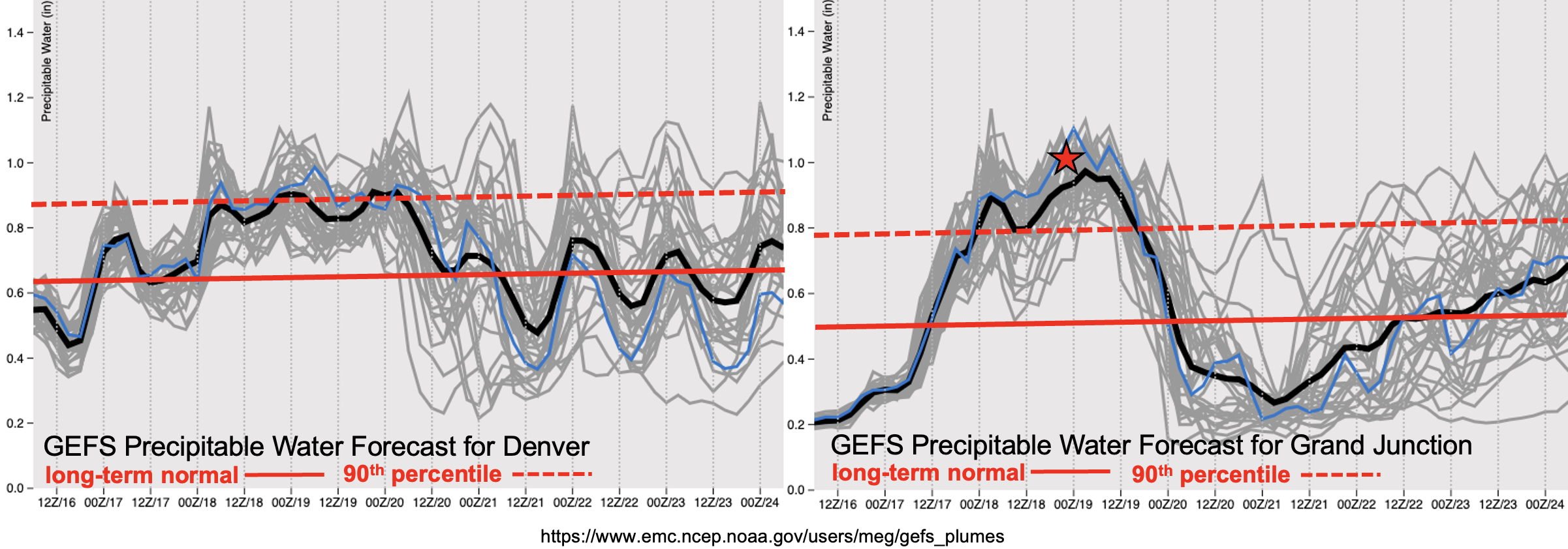
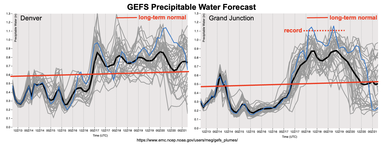
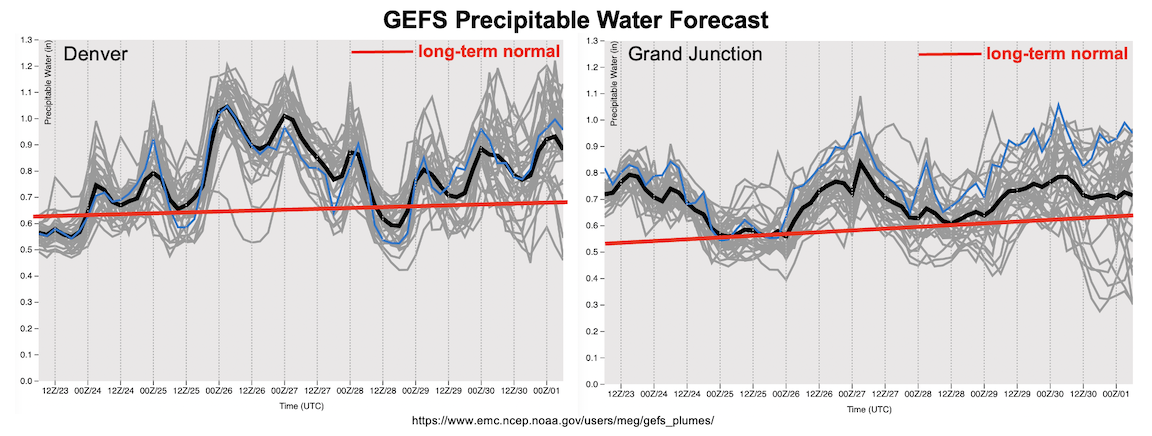
By Monday, the forecast PW plumes, below, show a brief post-frontal drying that will reduce precipitation coverage. However, this is only expected to be a brief drying, as moisture should continue to remain above normal through Independence Day weekend. At this time, it is too premature to identify a flood threat after Event #2, as those details will likely be better deduced in the daily Bulletins and next Outlook.
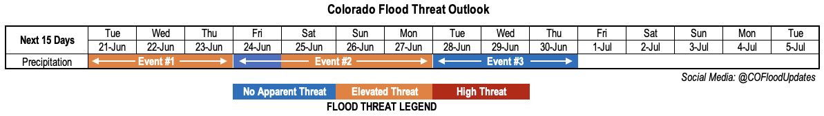
The identified precipitation events are described in more detail below.
Event #1: Friday (June 24)
No Apparent Flood Threat As Mainly Higher Terrain Storms Race Across The State
Marginal remaining subtropical moisture and limited instability will produce scattered showers and storms across mainly the Northern Mountains, Central Mountains and Front Range. Quick storm motion should limit point rainfall to about 0.5 inches, though most of this could fall in a quick 20-30 minute downpour.
Event #2: Saturday – Sunday (June 25 – June 26)
Elevated Flood Threat For Southern High Terrain, While Steady Rainfall Piles Up Further East
A moist cool front will enter the state Saturday morning. The key to the day’s heavy rainfall potential will be the cloud cover ahead of the cool front. At this time, the timing of the front suggests there will be limited instability outside of a small pocket over the Southeast Plains, Palmer Ridge, Southeast Mountains and Raton Ridge (possibly spilling westward into the San Juan Mountains). At least isolated heavy rainfall potential will exist where instability is highest, so an Elevated Flood Threat is warranted for the potential of rainfall exceeding 0.8 inches/30 minute and 1 inch/hour over the higher terrain.
By Sunday, the instability shifts slightly south and west with the primary area of concern being the San Juan Mountains. Once again, early cloud cover could make or break the heavy rainfall potential, but sufficient instability and slow storm motion currently warrants another day with an Elevated Flood Threat. Further east, steady moderate rain could produce up to 2 inches of rainfall over parts of the Raton Ridge and Southeast Plains by late Sunday. To have this occur in late June without a flood threat is downright amazing!
Event #3: Monday – Thursday (June 27 – June 30)
No Apparent Flood Threat, But Daily Scattered Showers And Storms Expected
Moisture will decrease a bit after Event #2, though enough of it will remain to fuel daily instability of 400+ J/kg of CAPE over the higher terrain. Coupled with slow storm motion under a weak upper-level ridge, this suggests at least brief heavy rainfall will be possible but it is premature to issue an Elevated threat.
Event #4: Friday – Sunday (July 1 – July 3)
No Apparent Flood Threat At This Time, But Bears Watching
Heading into Independence Day weekend, there are some indications of another Pacific cool front that will approach Colorado from the north. Thus, there may be an increase in precipitation chances over the Northeast and Southeast Plains. However, there is too much uncertainty regarding the timing and instability to warrant an Elevated flood threat. The next Outlook should have a much better look at this possible event.