Issue Date: Monday, June 20th, 2022
Issue Time: 3PM MDT
Valid Dates: 6/21 – 7/5
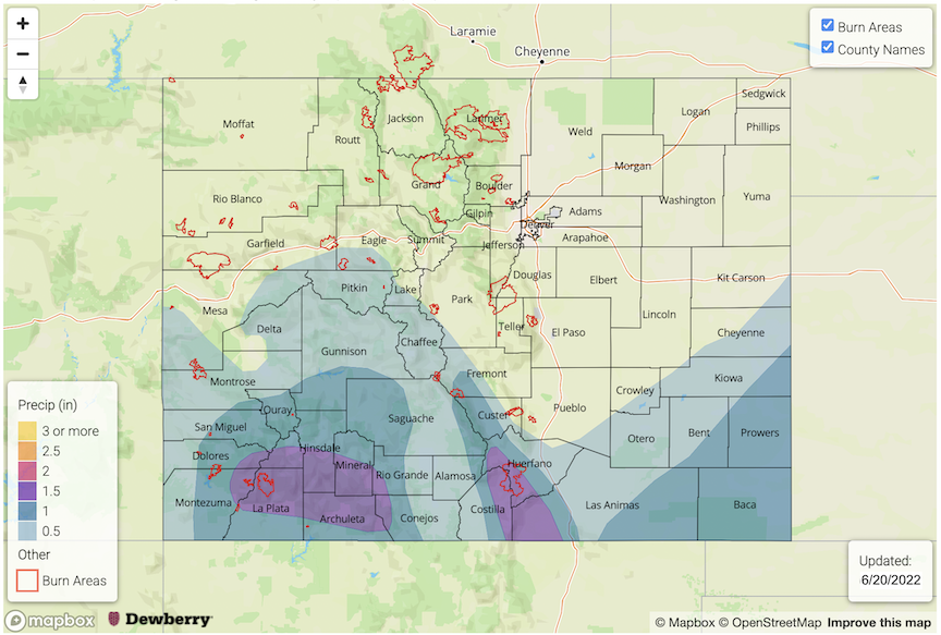
By the time we enter this late into June, it is quite unusual to receive significant amounts of rainfall with limited flooding. But that is exactly what occurred over the past 72-hours (see today’s State Precipitation Map discussion) over southwest Colorado. Fortunately, in this Outlook, we will see that this event was not just a one-off event. After a brief lull today, a plethora of moisture will re-enter and hang around Colorado over the entirety of this Outlook, setting the stage for widespread precipitation chances across a majority of our state!
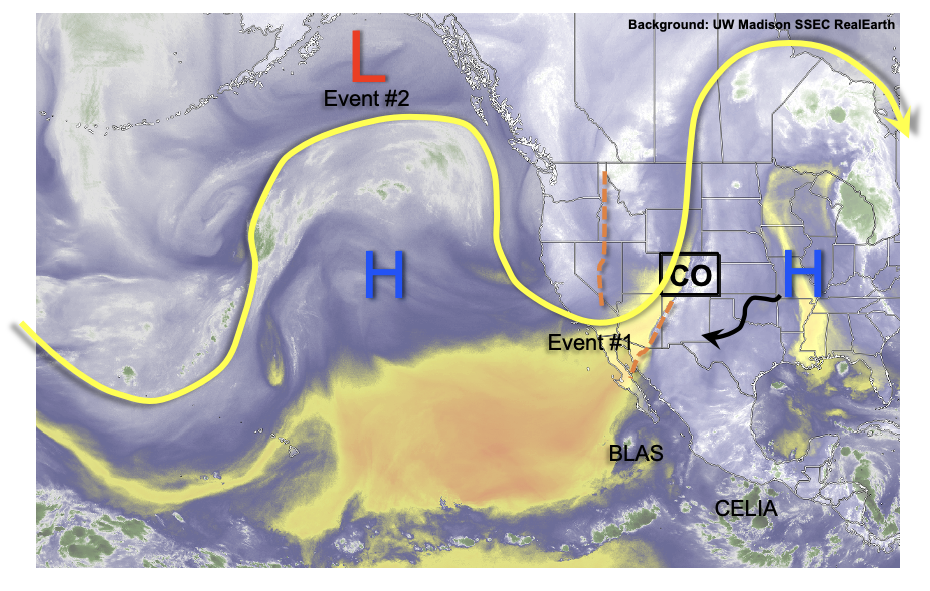
As seen in the water vapor image, below, the key features dictating our atmospheric pattern over the next week or so will be (1) the increasing importance of the upper-level ridge (currently to our east), (2) the continuous import of subtropical moisture, including indirectly through tropical disturbances Blas and Celia, and (3) synoptic-scale forcing coming from the eastern Pacific Ocean. The first round of precipitation, Event #1, will be driven mainly from a the subtropics, where as the second event will be associated with a cool and very moist Pacific frontal passage sometime this week.
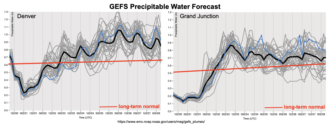
As shown in the forecast GEFS PW plumes, below, moisture content is expected to stay well above normal beginning late Tuesday through the foreseeable future. In fact, PW may exceed 1.0 inch by this weekend over eastern Colorado, whereas normal values for this time in June are in the 0.6-0.8 inch range. The other major factor supporting the threat of at least isolated heavy rainfall will be slow steering flow, a change from the recent event which had very quick steering flow. On the contrary, the major inhibiting factor in the potential for flooding in both Event #1 and #2 will be the limited instability. With generally warm mid-level temperatures expected due to the upper-level ridge moving back westward towards Colorado, only marginal to possibly moderate instability will be available. Nonetheless, the ability of our terrain to generate its own circulation suggests the possibility of slow-moving storms with at least short-term (1 hour duration) heavy rainfall potential. Thus, Events #1 and #2 have an Elevated flood threat.
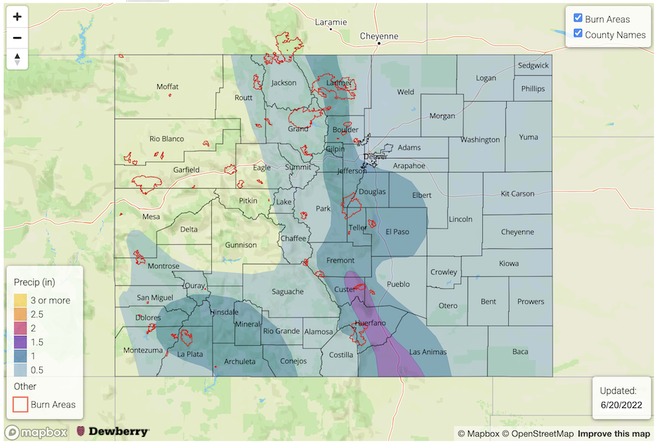
The other matter of importance is the increasing role of saturated soil in raising the chances of mud flows, debris slides and overall runoff. Given Colorado’s steep terrain, typical Flash Flood Guidance (FFG) for 1-hour rainfall is in the 0.75-1.5 inch range, depending on the exact steepness as well as soil type and land cover. As an aside, note that FFG can be as high as 3.0+ inches/hour over sandy, flat parts of the South Platte and Arkansas River valleys of eastern Colorado. The mountainous 0.75-1.50 inch thresholds will be substantially lower over locations that have received significant rainfall. By “significant”, a general rule of thumb is 0.25 inches per day (especially over large areas), which greatly reduces the ability of the soil to uptake more rainfall the following day.
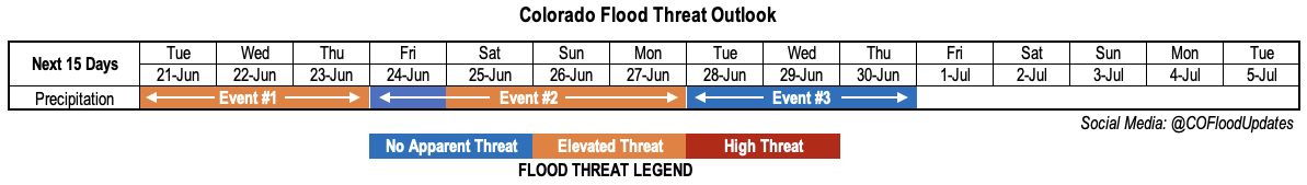
The identified precipitation events are described in more detail below.
Event #1: Tuesday – Thursday (June 21 – June 23)
Low-end Elevated Flood Threat For Scattered Heavy Rainfall Amidst More Stratiform Precipitation
Another subtropical moisture surge will arrive into Colorado late Tuesday afternoon. On Tuesday, most of the precipitation with this is expected to be in the form of a decaying convective complex from earlier storms in central New Mexico. However, enough instability will exist over the southern San Juan Mountains to cause slow-moving storms capable of 1.0 inch per hour of rainfall.
By Wednesday and Thursday, an increase in precipitation chances is expected for most of southern Colorado. However, it remains to be seen how much instability will be available. At present, it appears that a Low-end Elevated flood threat will exist both of the San Juan and Southeast Mountains, where 1.0 inch per hour rainfall intensity could occur with stronger storms. Further east, instability looks to be limited and only weak storms are expected, along with more general synoptic scale precipitation.
Event #2: Friday – Monday (June 24 – June 27)
Elevated Flood Threat Though Location And Potential Intensity Look Uncertain Due To Limited Instability
Friday looks to be a brief transition day between Event #1 and the aforementioned Pacific cool front set to arrive early Saturday morning. Thus, only isolated to widely scattered showers and storms with limited rainfall intensity are currently expected, mainly over the higher terrain.
By Saturday, the timing of the cool front passage will dictate which parts of the state will still have instability. Earlier guidance suggested enough instability for widespread showers and storms over southern and central Colorado. However, the latest guidance shows lower instability, meaning more of a lighter, stratiform rainfall. Nonetheless, areas further south will still see higher instability and a greater chance of heavy rainfall. By Sunday and Monday, typically post-frontal residual moisture over the Southeast Mountains, Raton Ridge and San Juan Mountains should continue to support scattered storm activity with heavy rainfall potential.
Event #3: Tuesday – Thursday (June 28 – June 30)
Well Above Normal Moisture To Maintain Precipitation Chances, But Intensity Uncertain; No Apparent Flood Threat
Without a mechanism to dry out the atmosphere, plenty of moisture will continue to persist under a wobbling upper-level ridge. With expected slow steering flow, this kind of pattern favors mainly higher terrain shower and storm potential. However, at this time, coverage and intensity remain too uncertain to create a precipitation map.