Issue Date: Monday, June 13th, 2022
Issue Time: 12PM MDT
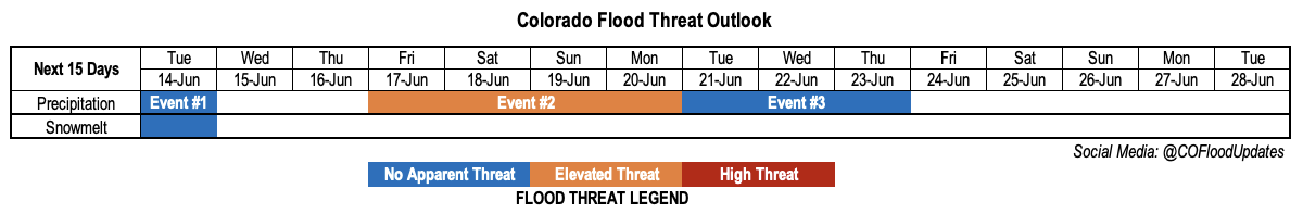
Valid Dates: 6/14-6/28
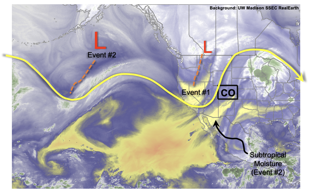
Only three weeks removed from a late spring snowstorm, we are now setting heat records across Colorado. Such are the vagaries of the spring to summer transition in our high elevation climate. This Outlook continues such a roller coaster theme, but with some decidedly positive news from the standpoint of precipitation chances. As shown in the water vapor image, below, a strong trough currently over the central Pacific Ocean will combine with a deep plume of subtropical moisture to fuel a multi-day widespread rainfall event (Event #2) across most of the western slope beginning Friday of this week. This is excellent news for the drought-stricken region, especially the San Juan Mountains, were an early snowmelt caused justified concerns about a potentially dangerous wildfire season. For the time being, those concerns should abate.
Until we get to Event #2, we will first see a strong cool front cross the state later today and into the overnight hours (Event #1). Between its Pacific origin and the fact that we are in summer, the front will have a hard time fully crossing Colorado and will instead stall out somewhere across the Southeast Plains. This will lead to some precipitation chances to the north of the cool front as a weak low pressure system spins up across this strong baroclinic zone (region with a strong temperature gradient). With very limited instability, only light to moderate showers and perhaps a weak storm are expected mainly over the Northeast Plains on Tuesday. Breezy or even windy conditions will cause an increase in the wildfire threat, as humidity values will plummet in the wake of the cool front. Thereafter, hot temperatures will return mainly over eastern areas as we wait for the deep moisture plume.
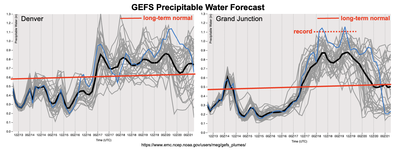
As shown in the forecast PW plumes below, moisture will re-enter the state in earnest by later on Thursday though precipitation will likely be limited due to the loss of daytime heating by that point. By Friday, however, PW will rise into the 0.8-1.0 inch range across central and western Colorado, fueling widespread shower and storm activity. This will continue Saturday through Monday, though it is too early to discuss the finer details. At this time, we are labeling Event #2 with an Elevated flood threat over the Friday – Monday period. The primary factor that should preclude a higher threat is the expected strong steering flow that would limit point rainfall into the 60 – 90 minute duration. There is also some notable model uncertainty: the GFS model system has the main PW plume considerably west of the European model. A further west solution would limit the heavy rainfall threat towards the Utah border, while the European model solution would push the heavy rainfall threat eastwards, possibly as far as the Sangre de Cristos. The latter solution could also warrant a higher threat, as storm training will be more of a concern. Nonetheless, there is strong consensus that some portion of the San Juan Mountains will experience a significant amount of rainfall over the 96 hours period of Event #2.
Lastly, a look at snowmelt progress (and corresponding streamflow) suggests peak flows over the next few days for most of the Front Range and Northern Mountain streams. Flows are expected to drop quickly over the next week or so as only small pockets of “hard to melt” snow remain.
The identified precipitation events are described in more detail below.
Event #1: Tuesday (June 14)
Showers And A Weak Storm Possible For Northeast Plains; No Apparent Flood Threat
A cool front will stall across eastern Colorado leading to the formation of a low pressure by Tuesday. Most of the state will experience significant drying, but some moisture will remain over the Northeast Plains (mainly along NE border) and support scattered showers and perhaps a weak storm by late afternoon. Max 1-hour rainfall will be limited to 0.25 inches so flooding is NOT expected.
Event #2: Friday – Monday (June 17 – June 20)
Elevated Flood Threat For Western Colorado As Prolonged Stretch Of Afternoon Storms Expected
Widespread showers and thunderstorms are expected Friday through Sunday across mainly the western slope. Highest coverage currently appears to be over the San Juan Mountains. Max 30-minute rainfall up to 0.8 inches can be expected with max 1-hour rainfall up to 1.2 inches. Swift storm motion appears to be the main factor precluding higher rain intensity, however, storm training could become a problem and warrant a higher threat. This will be better known in the next Outlook as well as the daily Bulletins.
By Monday, the main axis of the moisture plume should be north of Colorado, though at least isolated to scattered storms will still be possible over the San Juan, Central and Northern Mountains.
Overall, widespread rainfall above 1.0 inch is expected across most over the San Juan and Central Mountains. Preferred southward facing slopes of the San Juan Mountains will see up to 3.0 inches of rainfall over the course of this event! With this many consecutive days of heavy rainfall, the threat of mud flows and debris slides will increase every day over steep terrain that accumulates multiple storm passages.
Significantly more uncertainty exists about the rainfall chances to the east of the Continental Divide. With this magnitude of moisture, it is quite likely that at least some of the precipitation chances will “spill over” into the Palmer Ridge and/or Southeast Plains and Northeast Plains. However, this looks a bit less likely than in the previous Outlook, so flooding is not expected over these regions at this time.
Event #3: Tuesday – Thursday (June 21 – June 23)
Moisture And Rainfall Chances To Remain Though Amount And Location Uncertain; No Apparent Flood Threat
In the wake of Event #2, at least some residual moisture looks to remain in place over Colorado. At this time, the preferred region for shower and thunderstorm activity looks to stay over the San Juan Mountains. However, precipitation is not expected to exceed 0.5 inches at this time. The next Outlook should have more insight into whether this event will become more threatening.