Issue Date: Thursday, June 16th, 2022
Issue Time: 2:30PM MDT
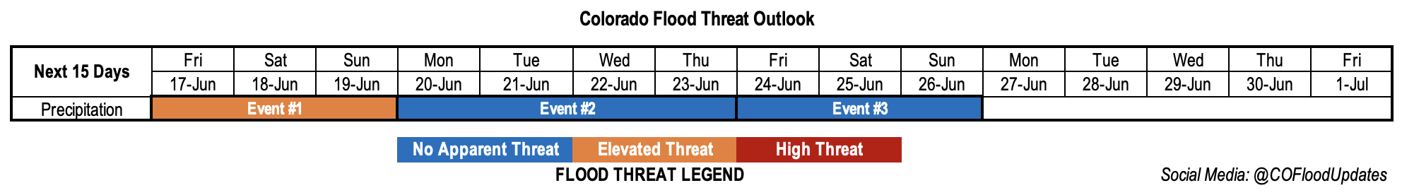
Valid Dates: 6/17 – 7/1
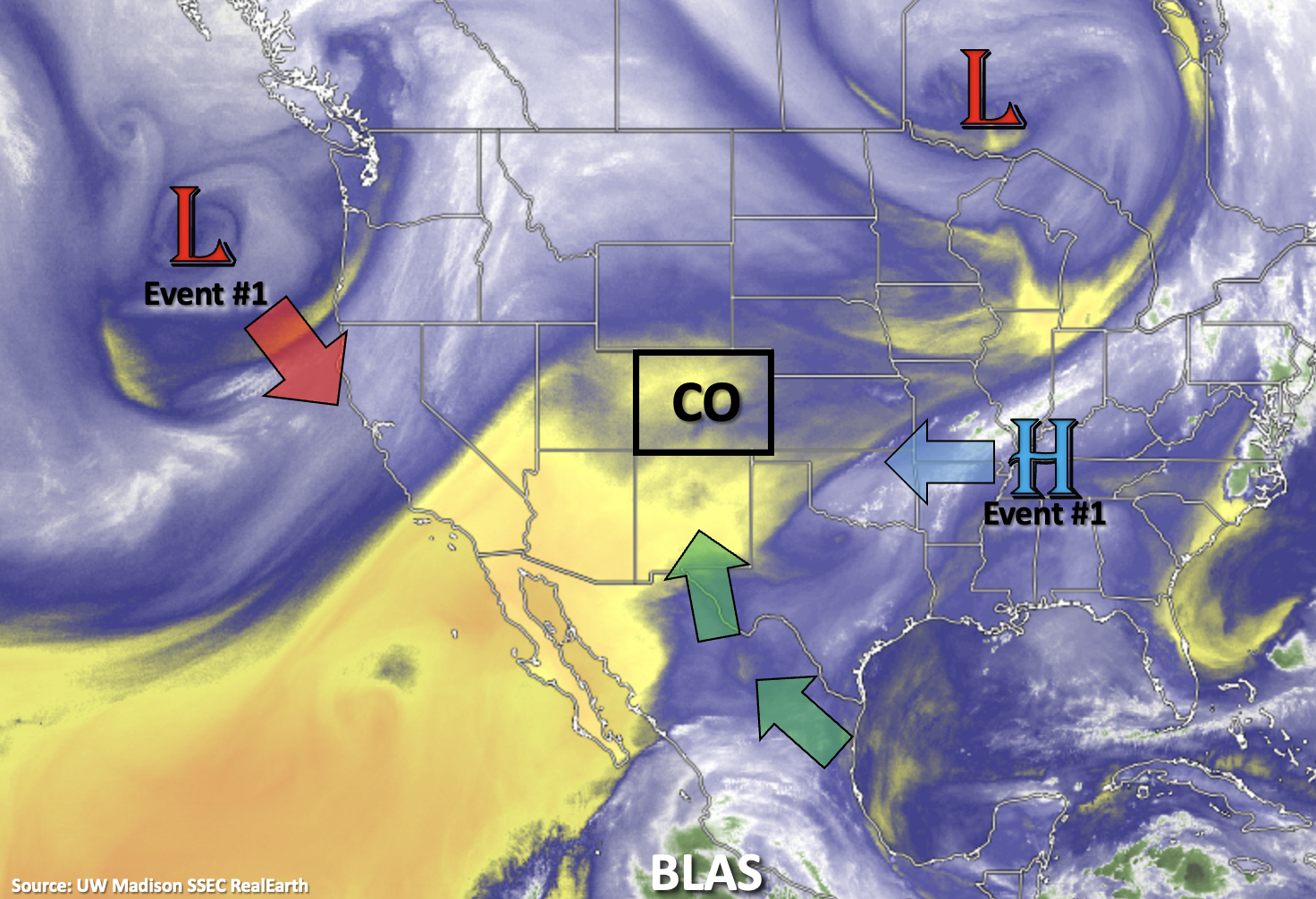
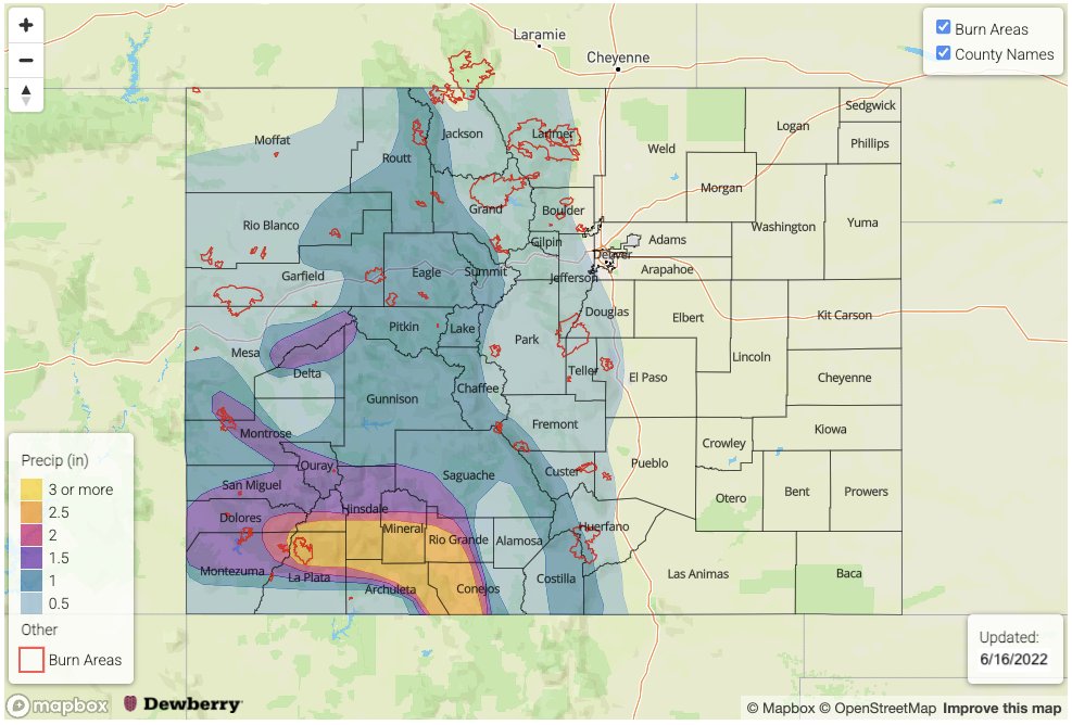
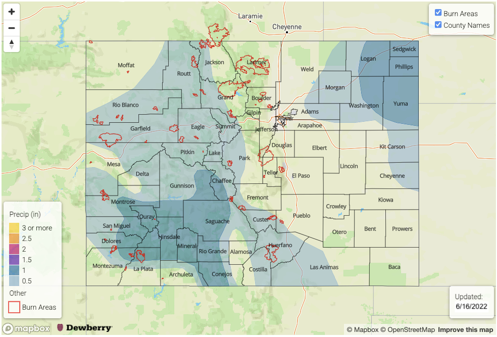
There is much higher confidence in today’s FTO that widespread rainfall will return to western Colorado and the mountains this weekend. An upper-level Low will move towards the coast of California and dig in place, while the High over the south begins to build back to the west. This pattern will create strong southerly flow over the Desert Southwest and pull a subtropical moisture plume northward into western Colorado. Likely adding to this moisture plume will be Hurricane Blas, which is also marked in the water vapor imagery below. Widespread rainfall is forecast to begin tomorrow and should last through the weekend causing an Elevated flood threat to be issued for Event #1. This flood threat includes recent burn areas, so be sure to track those daily flood threat forecasts in the Fire Burn Forecast table.
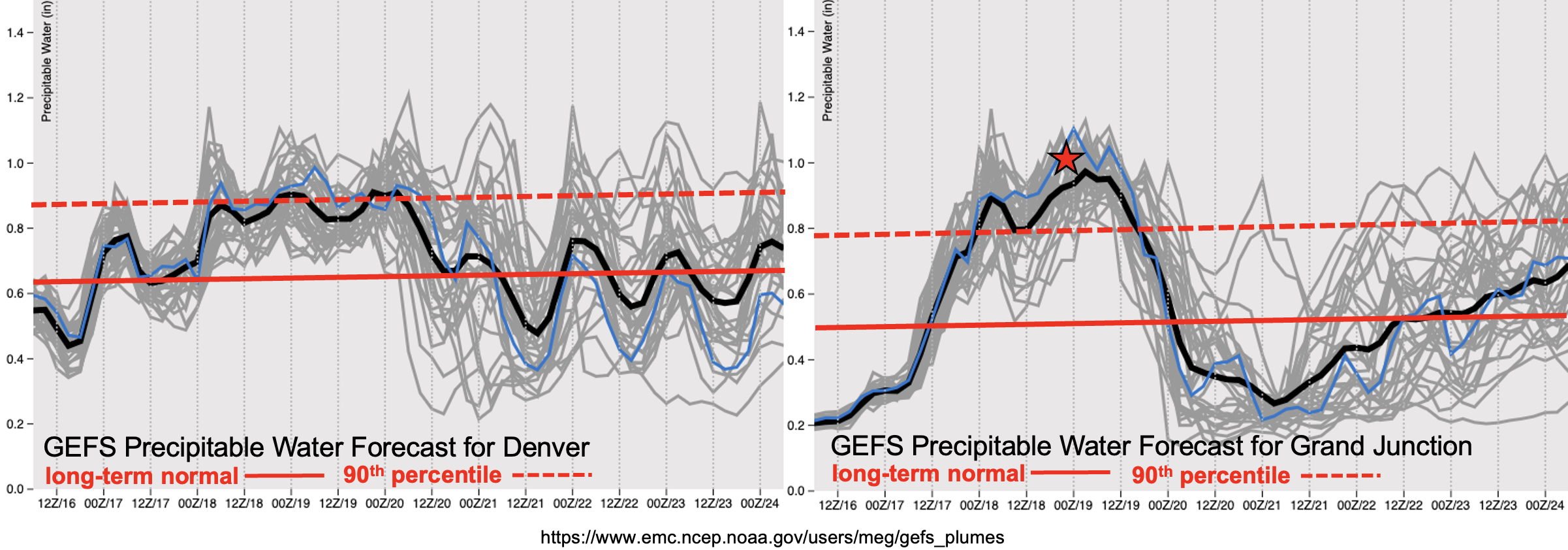
Below are the moisture plumes for Grand Junction (right) and Denver (left). Added to the time series for today’s FTO are the 90th percentile PW values for this time of year to show just how strong this plume of moisture is relative to climatology. While the moisture is notable over Denver, terrain driven storms with southerly steering flows should help to limit the flood threat over the adjacent eastern plains. Over western Colorado, it is possible that Grand Junction’s PW may reach the maximum moving average, which is around 1 inch (red star). It’s impressive how far north this moisture plume is reaching in the models. With the jet stream setting up just to our east and Colorado under the influence of some stronger upper-level winds, does seem likely that higher moisture values will reach the northern border.
For the most part, moisture looks to decrease at the start of next week, but it is likely that residual moisture will linger across the southern border, especially over the southwest quadrant of the state. Thus, we expect daily storms to continue to fire over the central/southern high terrains through next week (Event #2). It will also be possible for some storms to develop over the eastern plains on Tuesday behind the departing trough.
Finally, worth mentioning Event #3. There’s not much of a break between systems this week as another subtropical plume potentially moves northward at the start of next weekend. Right now, there is fairly good model consensus that this will occur. Really hoping this push of moisture continues to show up in the model runs as west-central and southwest Colorado are experiencing severe to extreme drought conditions. Be sure to tune back into the FTO on Monday for the latest.
Event #1: Friday – Sunday (6/17 – 6/19)
Elevated flood threat as the first subtropical moisture plume arrives to western Colorado.
Finally, some decent rainfall is forecast, which should help somewhat relieve the drought situation over western and southwestern Colorado. Rainfall begins tomorrow and will likely peak on Saturday as far as intensity. Initially, it may take some time for the boundary layer to moisten considering the Grand Junction dew point was measured at 18F this morning. This just means less rainfall accumulation initially at the lower elevation valleys on Friday. However, plenty of rainfall is still forecast on Saturday and Sunday, so southerly flow should help produce some meaningful accumulations at the lower elevations as storms move off the mountains. Heaviest rainfall is anticipated over the south facing slopes of the southern San Juan Mountains.
Due to the ongoing nature of the rainfall this weekend, with plenty of mid-level lift moving through the flow and the diurnal cycle, soils should slowly begin to saturate by late Saturday/Sunday. This will likely enhance runoff, which could cause some rises in local streams over the San Juan and Central Mountains. One limiting factor to the flash flood threat this weekend could be the inability to build instability for convection. However, if pockets of instability could develop over any area between shortwave impulses and breaks in cloud cover, embedded convection would likely help to increase the chance for mud flows and debris slides over the steeper terrains under the stronger storm cores. This is especially true over the south facing slopes of the San Juan Mountains where the soils are most likely to become saturated first. Thus, the Elevated flood threat being issued.
With mostly southerly steering flows during this event, unsure about very much moisture spillover into the Front Range and adjacent eastern plains. There will likely be a bit more of an easterly component to the flow on late Saturday into Sunday, so expect an uptick in storm chances over the Front Range during this period.
Be sure to tune into the FTB for your daily flood threat update as subtle features will likely indicate when and where the flood threat will occur.
Event #2: Monday – Thursday (6/20 – 6/23)
No Apparent Threat flood threat as residual moisture continues showers over the south/central mountains.
Moisture mixes out over north and central western Colorado early next week as dry westerly flow picks back up. However, some residual moisture looks to hold on over south and central Colorado, which should help drive the diurnal storm pattern. At this time there is No Apparent flood threat, but the continued rainfall and cooler conditions should help temper critical fire weather over the area. We will keep an eye out for dry lightning conditions in the daily FTB. Isolated storms may also return to eastern Colorado on Tuesday in association with a stalled-out front behind the departing trough. Less certainty in this outcome as far as location and the ability for storms to break the cap. There is also an outside shot for storms over the far eastern plains on Wednesday. As far as high temperatures, it starts to heat up by mid-week.
Event #3: Friday – Sunday (6/24 – 6/26)
No Apparent Threat as another potential plume of subtropical moisture is pulled northward.
Less confidence in the models this far out, but it seems there may be another surge of subtropical moisture northward for another round of widespread showers over western Colorado to end June. At this time, it looks like there should also be a better chance for storms to develop over the eastern mountains next weekend as flow aloft also gains an easterly component. With such low confidence, no map has been drawn. Hot temperatures also look to return to eastern Colorado with highs likely reaching 100F+ over the far eastern plains by Friday. Details are likely to change, so be sure to tune back into the FTO next Monday.