FTO 09-24-2015: One Rainfall Event In Sight, But No Flood Threat

Issue Date: 9/24/2015
Issue Time: 12:15PM

Note: Our final Flood Threat Outlook is next Monday, 9/28. Please check back then for a special winter snowpack forecast!

threat_timeline.20150924

The last week or so has seen a rekindling of heavy rainfall activity that was a staple during the early part of summer. Thunderstorms have occurred on several days, but due to marginal atmospheric instability and fast storm motion, heavy rainfall has been more a miss than a hit. During this Flood Threat Outlook, we anticipate a continuation of the transition from summer to fall. Weather-wise, this implies that the character of rainfall transitions from thunderstorm-driven to frontal driven.

watervapor_20150924
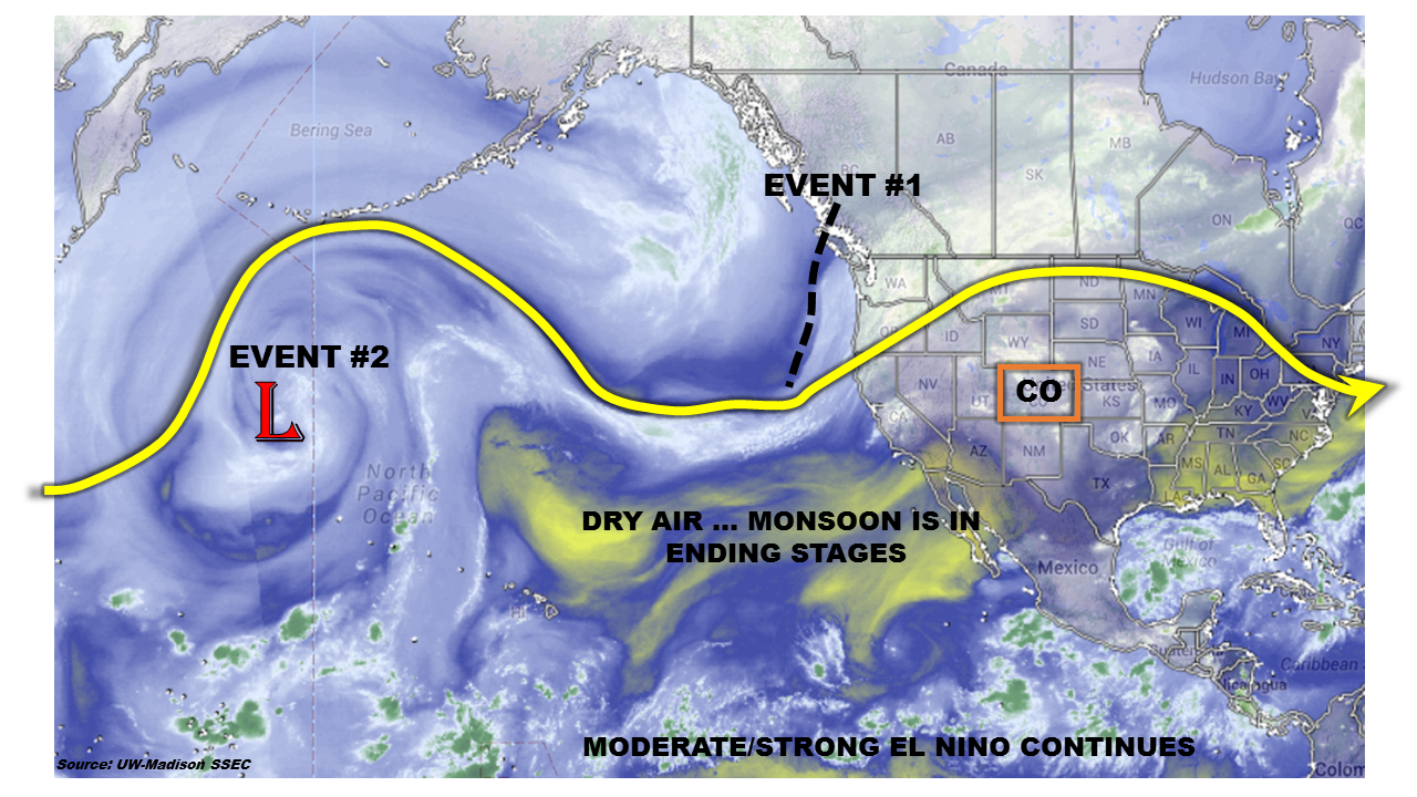
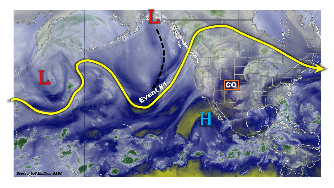
The water vapor image, above, shows the main features of the middle and upper-atmospheric circulation. A strong jet stream is found across southern Canada, extending far upstream into the North Pacific Ocean. A significant trough was located off the North American west coast. This trough will very slowly enter the continent and provide Colorado with a multi-day period of rainfall chances. Farther west, another trough/low-pressure system spins in the North Pacific. At this time, no impact is expected from this feature.

Thus, only one precipitation event is identified during this FTO. Details of this event follow.

Event #1 (Tuesday 9/29 – Friday 10/2):

No Apparent Flood Threat

A large-scale trough is expected to slowly approach the west coast of the U.S. By Tuesday (9/29) of next week, this feature is expected to impact Colorado. Atmospheric instability will once again be limited. Thus, it is not clear if there will be a potential for thunderstorm activity. Regardless, the passage of one or two cold fronts will maintain a chance of rainfall from Tuesday through Friday. As the cold front passages will be swift, rainfall will be on the light side. However, in total, between 0.5 and 0.75 inches of rain will be possible in the Central Mountains, Northern Mountains as well as the Front Range, Palmer Ridge and Northeast Plains. Thereafter, additional cold front passages will be likely during the week of Monday, 10/5. However, there are presently no indications that these events will lead to rainfall exceeding 0.5 inches.


Legend

FTO 09-21-2015: Three Events on the Horizon

Issue Date: 9/21/2015
Issue Time: 12:27 PM

Threat_Timeline_20150921

With the first official day of autumn only a few days away, the transition from the summer season is well underway. This transition manifests itself in changing leaves, cooler temperatures, and a more “active” storm track as the polar jet stream sags southward. A slightly more active pattern will be in place over the next 15 days, resulting in three events to discuss in this version of the Flood Threat Outlook. However, with the transition to fall also comes the transition to lessened moisture available to storms. For that reason, only one event garners an “elevated flood threat” distinction, while the other two show no apparent flood threat.

WV_20150921
The water vapor imagery tells the bulk of the story awaiting Colorado over the next 15 days. First, Event #1 is the result of the upper-level low sitting off CA/Baja coast funneling Tropical Depression 16-E into the southwestern US. A few days ago, it looked as if the significant moisture associated with the tropical disturbance would move northward into Colorado, but at the event has unfolded, it is becoming increasingly likely the bulk of the moisture remains over AZ/NM. After Event #1, drying and warming returns for a few days. More details on Event #1, plus discussions on Events #2 and #3 can be found in the event-specific discussions below.

Event #1: Tuesday (9-22-2015) and Wednesday (9-23-2015)

Elevated Flood Threat as Remnants of Tropical Depression 16-E Encroach on Southern Colorado

How far northward the tropical remnants will travel is the big question surrounding Event #1. Over the past few days, observational trends have shown that the track will likely take the best moisture south of Colorado and over New Mexico, leaving Colorado without widespread precipitation. Instead, it looks like the moisture shield will more or less encroach on Colorado, allowing for good moisture to filter into southern and far eastern portions of the state. Precipitable water values will climb to 0.8-1.25 inches in those areas. Instability will be limited by cloud cover, so heavy rainfall will be mitigated somewhat. Expect showers/thunderstorms to be efficient rain producers due to the amount of moisture available, and prolonged periods of rain will be the main focus for a developing flood threat. Be sure and check back in with the Flood Threat Bulletin tomorrow for the most up-to-date information.

Legend

Event #2: Saturday (9-26-2015) and Sunday (9-27-2015)

No Apparent Flood Threat from Potential Mountain Showers/Thunderstorms

Another upper-level low will southward along the west coast (purple “#2” in the water vapor image), with southwest flow bringing back moisture and the chance for rain in time for the weekend (9/26-9/27). This event hinges on the upper-level low over the central/southwestern US being shifted far enough eastward for moisture to return to Colorado. At this time, there is equal probability that the upper ridge either a) remains over Colorado, shutting off moisture and keeping the state dry and warm through the weekend, or b) shifts east due to influence of upper-level trough, allowing southwest flow and subtropical moisture to return.
If moisture returns, the result will mainly be mountain showers/thunderstorms, but significant precipitation is not expected (less than a half inch everywhere). This event will come into better focus over the next few days so stay tuned.

Event #3: Saturday (10-3-2015) through Monday (10-5-2015)

No Apparent Flood Threat

The upper-level trough mentioned in Event #2 will finally look to move across the western US during this time period. How potent this system will be as it moves across Colorado, and the amount of moisture available, remains to be seen; a more northward track will keep precipitation out of Colorado, but a more southern track will bring the bulk of rainfall to the state. At this time, with plenty of uncertainty surrounding Event #3, no precipitation map is warranted.

FTO 09-17-2015: Season Winding Down, Two Events on the Horizon

Issue Date: 9/17/2015
Issue Time: 1:22 PM

Threat_Timeline_20150917

As the season winds down, we often see Nature’s last gasps at any significant rainfall events. During this period, there will be one event that grabs attention, while the other remains too distant to show an apparent flood threat. Over the next few days, enough moisture will remain over Colorado to allow for isolated-to-scattered showers/weak thunderstorms to develop with the influence of weak disturbances aloft. No significant precipitation is expected with this activity, thus no event designation will be given. Following shortly after, Event #1 (9/22-9/24) will bring an elevated flood threat to western Colorado as the upper-level trough digs along the West Coast and then pushes across the Rockies. You can see the event lurking over the eastern Pacific on the water vapor image below.

WV_20150917
After Event #1, Colorado dries out for the remainder of the period, minus a potential event (Event #2) materializing for Tuesday and Wednesday (9/29-9/30). Low confidence exists for Event #2 bringing rainfall to Colorado, as the storm track looks to keep the rainfall north and east of the state. Outside of Event #2, there isn’t any other rainfall of which to speak in the extended range. Stay tuned.

Event #1: Tuesday (9-22-2015) through Thursday (9-24-2015)

Elevated Flood Threat, Western Colorado the Likely Target

Southwest flow aloft will increase with the approach of an upper-level trough from the west/southwest, allowing subtropical moisture to re-enter Colorado. This event will mainly be a western Colorado event, as a surface trough over the eastern Plains promotes downsloping winds/drying for areas east of the mountains. There is *some* disagreement in the amount of subtropical moisture that will be available, but there is good confidence that this will be a fairly wet period for western Colorado. Timing of shortwave disturbances will be important to watch; favorable timing will mean a greater risk for heavy rain, as well as increase precipitation chances for eastern Colorado.

Legend

Event #2: Tuesday (9-29-2015) and Wednesday (9-30-2015)

No Apparent Flood Threat, But Will Be Watching Closely

Event #2 is still coming into focus, and relatively low confidence exists in the event materializing for Colorado. Most likely, the storm track/disturbances pass too far to the north, keeping the rainfall north and east of Colorado. Any shift southward in the storm track would bring the rainfall to Colorado. At this time, this means that no flood threat designation is warranted, and we will continue watching and update the forecast with Monday’s edition of the FTO.

FTO 09-14-2015: Rainfall Chances To Continue, But With Only Brief Elevated Flood Threat

Issue Date: 9/14/2015
Issue Time: 2:25PM
Valid Dates: 9/15 – 9/29

Overview

threat_timeline.20150914

The most significant news of this Flood Threat Outlook is that the 2015 Southwest United States monsoon appears to be gradually closing up shop. Interestingly, given the presence of the moderate to strong El Nino, this early exit is consistent with what was observed in the past. And as the water vapor image shows, below, there exists a wide area of very dry conditions in the subtropical Pacific Ocean. However, despite the fact that the monsoon may shut off a little early, an active atmosphere over the North Pacific Ocean will continue to supply Colorado with rainfall chances throughout the coming 15-day period. Fortunately, aside from a very brief window next week, the rainfall will fall in a relatively calm fashion.

watervapor_20150914Two widespread precipitation events are identified during this edition of the Outlook. Let us look at each event separately.

Event #1: Tuesday (9/15) – Wednesday (9/16)

No Apparent Flood Threat With Rainfall Mostly West Of The Divide

The first event will be a continuation of today’s (Monday) rainfall in western Colorado. A large-scale trough will propagate over the northern Rockies, supporting two additional days of rainfall. With the very fast steering flow overhead and only limited instability, numerous rounds of showers and perhaps a weak thunderstorm will characterize this period. However, rainfall will be largely limited to western Colorado, as downsloping flow will prevent rainfall over the eastern Plains. In all, up to 1 inch of rainfall will be possible in isolated regions of the Northern Mountains, Central Mountains and San Juans. In lower elevations, 0.25 to 0.5 inches of rain can be expected.

Legend

Event #2: Wednesday (9/23) – Friday (9/25)

Brief Elevated Flood Threat, Followed By Non-Threatening Rainfall

After Event #1, conditions quite down for a prolonged period of time. Then, current guidance suggests that another large-scale trough will get organized in the North Pacific and come ashore the western North American coastline. Although instability will once again be a limiting factor (it is, after all, mid-September), the initial surge of moisture and atmospheric dynamics will provide for an Elevated flood threat over the Central Mountains. A round of thunderstorms is anticipated on Wednesday. These will be capable of 1 inch per hour rainfall that could cause some isolated flash flooding, mud flows and debris slides. Following this initial round of rainfall, widespread light to moderate rainfall will be possible on Thursday and Friday. Again, most of the action appears will likely be limited to western Colorado, but a cold front passage on Thursday may help the Northeast Plains get some much needed rainfall. At this time, rainfall on Thursday and Friday is expected to be limited to about 0.5 inches.

Legend