Issue Date: 9/17/2015
Issue Time: 1:22 PM

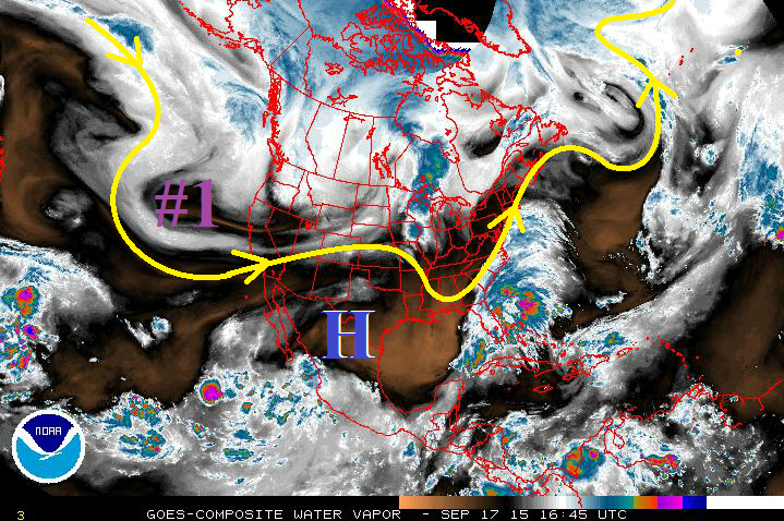
As the season winds down, we often see Nature’s last gasps at any significant rainfall events. During this period, there will be one event that grabs attention, while the other remains too distant to show an apparent flood threat. Over the next few days, enough moisture will remain over Colorado to allow for isolated-to-scattered showers/weak thunderstorms to develop with the influence of weak disturbances aloft. No significant precipitation is expected with this activity, thus no event designation will be given. Following shortly after, Event #1 (9/22-9/24) will bring an elevated flood threat to western Colorado as the upper-level trough digs along the West Coast and then pushes across the Rockies. You can see the event lurking over the eastern Pacific on the water vapor image below.
After Event #1, Colorado dries out for the remainder of the period, minus a potential event (Event #2) materializing for Tuesday and Wednesday (9/29-9/30). Low confidence exists for Event #2 bringing rainfall to Colorado, as the storm track looks to keep the rainfall north and east of the state. Outside of Event #2, there isn’t any other rainfall of which to speak in the extended range. Stay tuned.
Event #1: Tuesday (9-22-2015) through Thursday (9-24-2015)
Elevated Flood Threat, Western Colorado the Likely Target
Southwest flow aloft will increase with the approach of an upper-level trough from the west/southwest, allowing subtropical moisture to re-enter Colorado. This event will mainly be a western Colorado event, as a surface trough over the eastern Plains promotes downsloping winds/drying for areas east of the mountains. There is *some* disagreement in the amount of subtropical moisture that will be available, but there is good confidence that this will be a fairly wet period for western Colorado. Timing of shortwave disturbances will be important to watch; favorable timing will mean a greater risk for heavy rain, as well as increase precipitation chances for eastern Colorado.

Event #2: Tuesday (9-29-2015) and Wednesday (9-30-2015)
No Apparent Flood Threat, But Will Be Watching Closely
Event #2 is still coming into focus, and relatively low confidence exists in the event materializing for Colorado. Most likely, the storm track/disturbances pass too far to the north, keeping the rainfall north and east of Colorado. Any shift southward in the storm track would bring the rainfall to Colorado. At this time, this means that no flood threat designation is warranted, and we will continue watching and update the forecast with Monday’s edition of the FTO.