Issue Date: 9/14/2015
Issue Time: 2:25PM
Valid Dates: 9/15 – 9/29
Overview

The most significant news of this Flood Threat Outlook is that the 2015 Southwest United States monsoon appears to be gradually closing up shop. Interestingly, given the presence of the moderate to strong El Nino, this early exit is consistent with what was observed in the past. And as the water vapor image shows, below, there exists a wide area of very dry conditions in the subtropical Pacific Ocean. However, despite the fact that the monsoon may shut off a little early, an active atmosphere over the North Pacific Ocean will continue to supply Colorado with rainfall chances throughout the coming 15-day period. Fortunately, aside from a very brief window next week, the rainfall will fall in a relatively calm fashion.
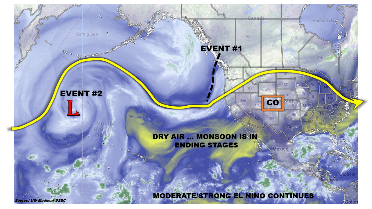 Two widespread precipitation events are identified during this edition of the Outlook. Let us look at each event separately.
Event #1: Tuesday (9/15) – Wednesday (9/16)
No Apparent Flood Threat With Rainfall Mostly West Of The Divide
The first event will be a continuation of today’s (Monday) rainfall in western Colorado. A large-scale trough will propagate over the northern Rockies, supporting two additional days of rainfall. With the very fast steering flow overhead and only limited instability, numerous rounds of showers and perhaps a weak thunderstorm will characterize this period. However, rainfall will be largely limited to western Colorado, as downsloping flow will prevent rainfall over the eastern Plains. In all, up to 1 inch of rainfall will be possible in isolated regions of the Northern Mountains, Central Mountains and San Juans. In lower elevations, 0.25 to 0.5 inches of rain can be expected.

Event #2: Wednesday (9/23) – Friday (9/25)
Brief Elevated Flood Threat, Followed By Non-Threatening Rainfall
After Event #1, conditions quite down for a prolonged period of time. Then, current guidance suggests that another large-scale trough will get organized in the North Pacific and come ashore the western North American coastline. Although instability will once again be a limiting factor (it is, after all, mid-September), the initial surge of moisture and atmospheric dynamics will provide for an Elevated flood threat over the Central Mountains. A round of thunderstorms is anticipated on Wednesday. These will be capable of 1 inch per hour rainfall that could cause some isolated flash flooding, mud flows and debris slides. Following this initial round of rainfall, widespread light to moderate rainfall will be possible on Thursday and Friday. Again, most of the action appears will likely be limited to western Colorado, but a cold front passage on Thursday may help the Northeast Plains get some much needed rainfall. At this time, rainfall on Thursday and Friday is expected to be limited to about 0.5 inches.