Issue Date: 9/21/2015
Issue Time: 12:27 PM

With the first official day of autumn only a few days away, the transition from the summer season is well underway. This transition manifests itself in changing leaves, cooler temperatures, and a more “active” storm track as the polar jet stream sags southward. A slightly more active pattern will be in place over the next 15 days, resulting in three events to discuss in this version of the Flood Threat Outlook. However, with the transition to fall also comes the transition to lessened moisture available to storms. For that reason, only one event garners an “elevated flood threat” distinction, while the other two show no apparent flood threat.
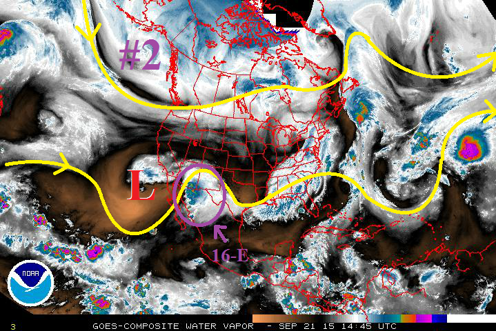
The water vapor imagery tells the bulk of the story awaiting Colorado over the next 15 days. First, Event #1 is the result of the upper-level low sitting off CA/Baja coast funneling Tropical Depression 16-E into the southwestern US. A few days ago, it looked as if the significant moisture associated with the tropical disturbance would move northward into Colorado, but at the event has unfolded, it is becoming increasingly likely the bulk of the moisture remains over AZ/NM. After Event #1, drying and warming returns for a few days. More details on Event #1, plus discussions on Events #2 and #3 can be found in the event-specific discussions below.
Event #1: Tuesday (9-22-2015) and Wednesday (9-23-2015)
Elevated Flood Threat as Remnants of Tropical Depression 16-E Encroach on Southern Colorado
How far northward the tropical remnants will travel is the big question surrounding Event #1. Over the past few days, observational trends have shown that the track will likely take the best moisture south of Colorado and over New Mexico, leaving Colorado without widespread precipitation. Instead, it looks like the moisture shield will more or less encroach on Colorado, allowing for good moisture to filter into southern and far eastern portions of the state. Precipitable water values will climb to 0.8-1.25 inches in those areas. Instability will be limited by cloud cover, so heavy rainfall will be mitigated somewhat. Expect showers/thunderstorms to be efficient rain producers due to the amount of moisture available, and prolonged periods of rain will be the main focus for a developing flood threat. Be sure and check back in with the Flood Threat Bulletin tomorrow for the most up-to-date information.

Event #2: Saturday (9-26-2015) and Sunday (9-27-2015)
No Apparent Flood Threat from Potential Mountain Showers/Thunderstorms
Another upper-level low will southward along the west coast (purple “#2” in the water vapor image), with southwest flow bringing back moisture and the chance for rain in time for the weekend (9/26-9/27). This event hinges on the upper-level low over the central/southwestern US being shifted far enough eastward for moisture to return to Colorado. At this time, there is equal probability that the upper ridge either a) remains over Colorado, shutting off moisture and keeping the state dry and warm through the weekend, or b) shifts east due to influence of upper-level trough, allowing southwest flow and subtropical moisture to return.
If moisture returns, the result will mainly be mountain showers/thunderstorms, but significant precipitation is not expected (less than a half inch everywhere). This event will come into better focus over the next few days so stay tuned.
Event #3: Saturday (10-3-2015) through Monday (10-5-2015)
No Apparent Flood Threat
The upper-level trough mentioned in Event #2 will finally look to move across the western US during this time period. How potent this system will be as it moves across Colorado, and the amount of moisture available, remains to be seen; a more northward track will keep precipitation out of Colorado, but a more southern track will bring the bulk of rainfall to the state. At this time, with plenty of uncertainty surrounding Event #3, no precipitation map is warranted.