FTO 06-02-2016: Warmer Period Ahead with Rainfall Chances In Question

Issue Date: Thursday, June 2nd, 2016
Issue Time: 12:45PM MDT

wv_markup

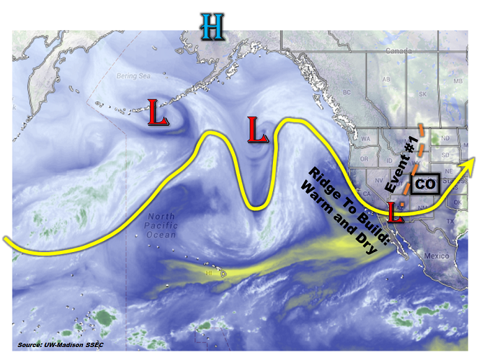
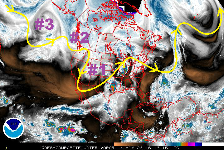
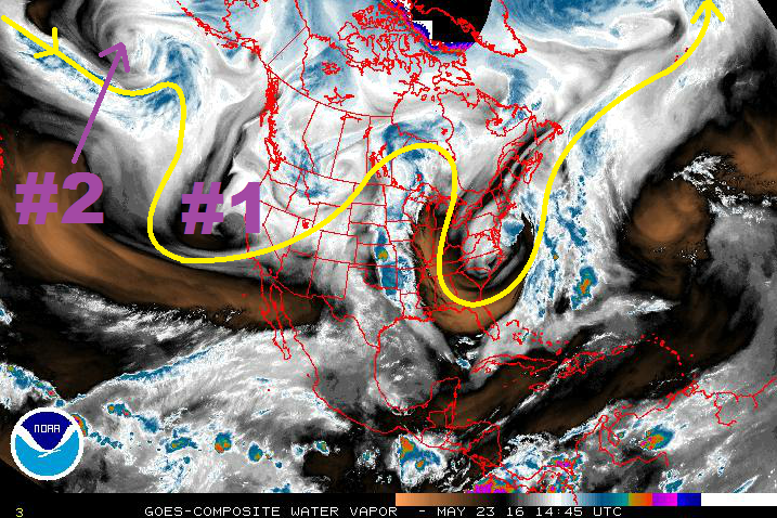
As discussed in today’s (6/2) Flood Threat Bulletin and shown in the expanded water vapor image, below, a ridge has begun to expand across the US west coast. Under the ridge, temperatures will certainly feel like summer with parts of Arizona forecast to be 5-15F above normal for the next 3-5 days. For Colorado, the ridge will not be an intense heat producer as much as it will block the upstream flow from disturbances. While in the past few days, it appeared that the ridge could setup for a prolonged period of time (7+ days), this is no longer certain. Instead, several low-pressure disturbance have the potential to propagate and weaken the ridge during the middle part of next week (6/7 – 6/9).

wv_markup

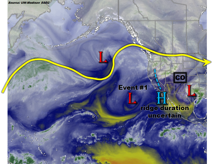
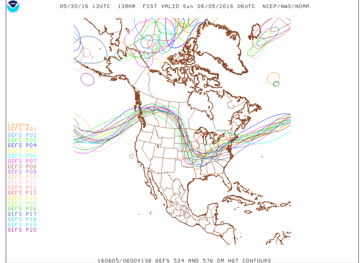
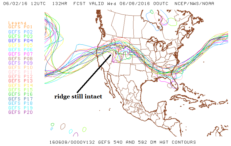
Of particular note are the labeled low-pressure disturbances in the eastern Pacific Ocean. These are forecast to move towards the western US coast and could dent the ridge. However, the main word here is “could”. At this moment, while there is certainly a chance that the disturbances make it all the way into Colorado, this does not appear like a given or even probable. For example, the spaghetti plot below shows the spread in GFS ensemble guidance for the position of the southern disturbance for mid next-week. While most of the ensembles have the slight trough feature that identifies the disturbance near the UT/CO border, it is also clear that the larger-scale pattern shows a ridge. This kind of setup is not particularly conducive to heavy rainfall chances across the state, especially because the extent of sufficient return flow (i.e. moisture feed from the Gulf of Mexico) is in doubt. A similar pattern follows for week 2 of the forecast period: the ridge is largely intact, but several disturbances could modulate its strength. However, no identifiable events exist at this time.

gfs_ens

Below we describe next week’s event in more detail.

Event #1: Tuesday 6/7 – Thursday 6/9

No Apparent Flood Threat as ridge strength and duration is uncertain

The cut-off low and large-scale trough features currently found in the eastern Pacific will progress east and potentially begin to flatten the ridge located over the western Rocky Mountain states. One or both of these features could penetrate far enough east to organize shower and thunderstorm activity mainly over northern and northeastern Colorado. However, at this moment, it does not appear that these events will be able to generate widespread precipitation above 1 inch. Thus, no precipitation map is provided today.

FTO 05-30-2016: Elevated Flood Threat Tuesday, Followed By Prolonged Warm and Dry Period

Issue Date: Monday, May 30th, 2016
Issue Time: 12:45PM MDT

threat_timeline

May has been a cool month for most of Colorado (see our Storm Total Precipitation discussion for 5/30/2016). As the water vapor image shows, below, an amplified pattern with at least two distinct ridge-trough couplets is seen across the vast North Pacific Ocean. At face value, this may seem to suggest that unsettled weather will continue as these features move east in the jet stream’s steering winds. But given that we are about to enter the first week of June, this is never guaranteed! Indeed, it appears that after tomorrow’s passage of a large-scale trough (Event #1) that will deliver widespread showers and thunderstorms, the overall pattern will calm down significantly.

watervapor_20160530

The reason for a calmer pattern will be the development of a stout early summer ridge that is currently in its infancy off the southwest US coast. The map below shows the GFS ensembles’ depiction of the upper atmosphere’s pattern for next Sunday 6/5. Note that by this time, there is essentially unanimous support for a ridge that covers the entire western United States. The implications of this are a prolonged warm and mainly dry period for Colorado starting mid-week last through at least mid-week next week. This does not imply that rainfall will not be found, but simply that it will be generally light and likely favoring high-elevation locations in accordance with Colorado’s summer climatology.

gfs_500mb

Thereafter, guidance is no longer as consistent, with some suggestions of the ridge quickly breaking down and storminess returning east of the Divide. There is enough loose consensus for us to bring in Event #2 starting late next week. However, there is not enough consensus to be able to estimate rainfall amounts, yet.

Event #1: Tuesday, May 31st

Elevated Flood Threat for Southeast Colorado

A cut-off low will propagate eastward, providing favorable dynamics for a widespread rain event for the Palmer Ridge, Southeast Mountains, Raton Ridge, Southeast Plains and parts of the Urban Corridor. A cool front passage will limit instability the farther north one goes, thus lighter rainfall rates will result north of Colorado Springs. In areas to the south, rainfall amounts up to 2 inches will be possible as at least one round of thunderstorms moves through the area during the afternoon and evening hours. An elevated flood threat is warranted for this region. Check out tomorrow’s Flood Threat Bulletin for the most up-to-date discussion and rainfall estimates.


Legend

Event #2: Saturday, June 11th through Monday, June 13th

No Apparent Flood Threat as timing of ridge weakening is uncertain

After a prolonged warm and mainly dry period, there are indications that the upper-level ridge will break down. This will open up the door for northwest flow and disturbances that could generate heavy rainfall mainly east of the Continental Divide. At this time, there is not enough guidance to pinpoint rainfall amounts. However, climatologically speaking, the northeast part of the state, including the Front Range and Urban Corridor, is the most likely target for the threat.

FTO 05-26-2016: 3 Events in the Next 15 Days

Issue Date: 5/26/2016
Issue Time: 1:05 PM

Threat_Timeline_20160526

The water vapor image below highlights the fairly active/transient pattern that will mark the next 15 days. Event #1 is a continuation from Monday’s FTO; the upper-level trough continues to behave as expected, moving east-northeastward across the central Rockies and into the Central US Plains. After Event #1, residual moisture will allow scattered thunderstorms to develop during the afternoon/evening on Saturday and Sunday. Event #2 will skirt across the Central/Northern Rockies, ejecting from the Pacific NW late Sunday (5/29), early Monday (5/30). The upper-level trough associated with Event #2 will not dig along the West Coast as the last couple have, allowing it to move eastward quickly. This will not only shorten the period between events #1 and #2, but it also will allow the low to move out of the region in fairly short order.

WV_20160526

Stronger ridging will build in behind Event #2, allowing for a brief drying/warming period. The main circulation associated with Event #3 will remain anchored to, or near, its current position. It will, however, eject a shortwave trough that will move across the western US and across Colorado late next week/over the weekend. Ensemble model solutions diverge on the exact timing, path, and evolution of this wave, so uncertainty is high. Updates will be given in the Monday FTO. After the wave of Event #3, ridging will build across the west, and the Summer heat will be on.

Event #1: Friday (05-27-2016)

Elevated Flood Threat Continues as Upper-Level Low Exits Region

The upper-level low/trough will continue to slide to the east, keeping broad-scale lift overhead. Surface moisture will remain across eastern Colorado, especially in the wake of today’s shower/thunderstorm activity. Storms will be ongoing during the morning hours tomorrow, then another round of showers and thunderstorms will fire up in the afternoon. Stay tuned to tomorrow’s FTB for an update.

Legend

Event #2: Monday (05-30-2016) and Tuesday (05-31-2016)

Elevated Flood Threat

This upper-level trough will begin to eject eastward late Sunday (5/29), early Monday (5/30). Colorado will see an uptick in showers/thunderstorms beginning on Monday. Leeside trough-ing will transport good surface moisture into eastern Colorado, setting the stage for showers and thunderstorms on Monday and Tuesday. Dewpoints in the 40s/50s will be enough moisture for the production of moderate-to-heavy rainfall.

Legend

Event #3: Friday (06-03-2016) through Sunday (06-05-2016)

No Apparent Flood Threat Due to Diverging Solutions

Ensemble model solutions diverge on the exact timing, path, and evolution of this wave (mentioned above). No precipitation map will be made due to considerable uncertainty. Stay tuned to future FTO’s for updates on this time period.

FTO 05-23-2016: Two Elevated Flood Threats on the Horizon

Issue Date: 5/23/2016
Issue Time: 1:18 PM

Threat_Timeline_20160523

Looking at the water vapor image below, it is fairly easy to pick out the two events highlighted in this edition of the FTO. Event #1 is a short duration event, brought on by a passing upper-level trough. Event #2, on the other hand, opens up an extended period where daily threats will need to be assessed thanks to a persistent West Coast trough and stalled mid-/upper-level low.

Prior to Event #1, severe weather will make a return to northeast and far eastern Colorado on Tuesday. A surface low will develop over southeastern CO/western KS, with flow around the center bringing moisture back into northeastern Colorado. Daytime heating will contribute to the development of strong instability, especially near the eastern border where CO, KS, and NE all meet. A Denver Cyclone will be in place, providing a local enhancement/convergence to thunderstorm development. The main threats will be large hail and damaging winds, including a couple tornadoes. The flood threat will be assessed tomorrow, hinging on how much moisture can move back into Colorado and the expected storm motions.

WV_20160523

Event #1 will take place on Thursday (5/26) and Friday (5/27), as the upper-level low/trough slides to the east, moving across the 4-corners first, then across Colorado and over the Central US Plains. Broad scale lift aloft will overspread low-level moisture across Eastern Colorado. Easterly, upslope flow will bring the best chance of precipitation, including localized heavy rain, to the southern Front Range, Southeast Mountains, southern Urban Corridor, Palmer Ridge, and Southeast Plains.

For Event #2, a shortwave associated with the long-wave trough will move into the Pacific Northwest on Saturday (5/28), bringing south-southwesterly flow aloft back to Colorado. This trough-ing along the West Coast becomes persistent, being reinforced by shortwave troughs that round the base of the trough and eject across Colorado. These shortwaves will bring “bursts” of upper-level support for scattered thunderstorm development. The end of Event #2 will be brought on by its own reinforcements. By Wednesday (6/1), a stronger, upper-level low will dig into the Pacific Northwest, deepening the persistent trough. This low will then stall over the Great Basin before opening up and lifting to the northeast on Sunday (6/5), well north of Colorado. The introduction of the strong upper-low will deepen the upper-level trough, allowing the upper-level ridge across the central US to retrograde westward. The presence of the ridge will introduce a warming and drying trend that will look to continue through the remainder of the period.

Event #1: Thursday (05-26-2016) and Friday (05-27-2016)

Elevated Flood Threat as Upslope Flow Pools Moisture near Mountains

The upper-level low/trough will slide to the east, introducing broad scale lift aloft overtop low-level moisture across Eastern Colorado. Easterly, upslope flow will bring the best chance of precipitation, including localized heavy rain, to the southern Front Range, Southeast Mountains, southern Urban Corridor, Palmer Ridge, and Southeast Plains. Stay tuned to the daily FTB.

Legend

Event #2: Saturday (05-28-2016) through Wednesday (06-01-2016)

Elevated Flood Threat as Low-Level Moisture Increases across Eastern Colorado

South-southwesterly flow aloft will return to Colorado as an upper-level trough moves back into the Pacific Northwest. The persistent trough-ing will be reinforced by shortwave troughs that round the base of the trough and eject across Colorado. These shortwaves will bring “bursts” of upper-level support for scattered thunderstorm development, while High pressure over the central US transports low-level moisture back into eastern Colorado. This period has the early looks of an active severe weather period for eastern Colorado, especially the eastern Plains, so stay tuned. An update to this period will be provided in Thursday’s FTO.

Legend