Issue Date: 5/26/2016
Issue Time: 1:05 PM

The water vapor image below highlights the fairly active/transient pattern that will mark the next 15 days. Event #1 is a continuation from Monday’s FTO; the upper-level trough continues to behave as expected, moving east-northeastward across the central Rockies and into the Central US Plains. After Event #1, residual moisture will allow scattered thunderstorms to develop during the afternoon/evening on Saturday and Sunday. Event #2 will skirt across the Central/Northern Rockies, ejecting from the Pacific NW late Sunday (5/29), early Monday (5/30). The upper-level trough associated with Event #2 will not dig along the West Coast as the last couple have, allowing it to move eastward quickly. This will not only shorten the period between events #1 and #2, but it also will allow the low to move out of the region in fairly short order.
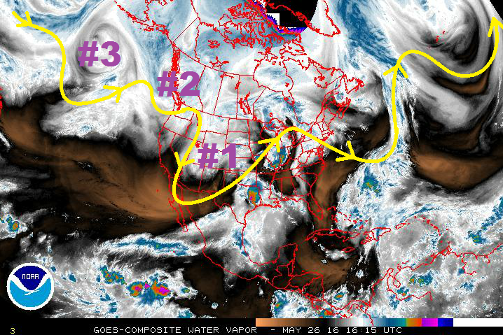
Stronger ridging will build in behind Event #2, allowing for a brief drying/warming period. The main circulation associated with Event #3 will remain anchored to, or near, its current position. It will, however, eject a shortwave trough that will move across the western US and across Colorado late next week/over the weekend. Ensemble model solutions diverge on the exact timing, path, and evolution of this wave, so uncertainty is high. Updates will be given in the Monday FTO. After the wave of Event #3, ridging will build across the west, and the Summer heat will be on.
Event #1: Friday (05-27-2016)
Elevated Flood Threat Continues as Upper-Level Low Exits Region
The upper-level low/trough will continue to slide to the east, keeping broad-scale lift overhead. Surface moisture will remain across eastern Colorado, especially in the wake of today’s shower/thunderstorm activity. Storms will be ongoing during the morning hours tomorrow, then another round of showers and thunderstorms will fire up in the afternoon. Stay tuned to tomorrow’s FTB for an update.

Event #2: Monday (05-30-2016) and Tuesday (05-31-2016)
Elevated Flood Threat
This upper-level trough will begin to eject eastward late Sunday (5/29), early Monday (5/30). Colorado will see an uptick in showers/thunderstorms beginning on Monday. Leeside trough-ing will transport good surface moisture into eastern Colorado, setting the stage for showers and thunderstorms on Monday and Tuesday. Dewpoints in the 40s/50s will be enough moisture for the production of moderate-to-heavy rainfall.
Event #3: Friday (06-03-2016) through Sunday (06-05-2016)
No Apparent Flood Threat Due to Diverging Solutions
Ensemble model solutions diverge on the exact timing, path, and evolution of this wave (mentioned above). No precipitation map will be made due to considerable uncertainty. Stay tuned to future FTO’s for updates on this time period.