Issue Date: 5/23/2016
Issue Time: 1:18 PM

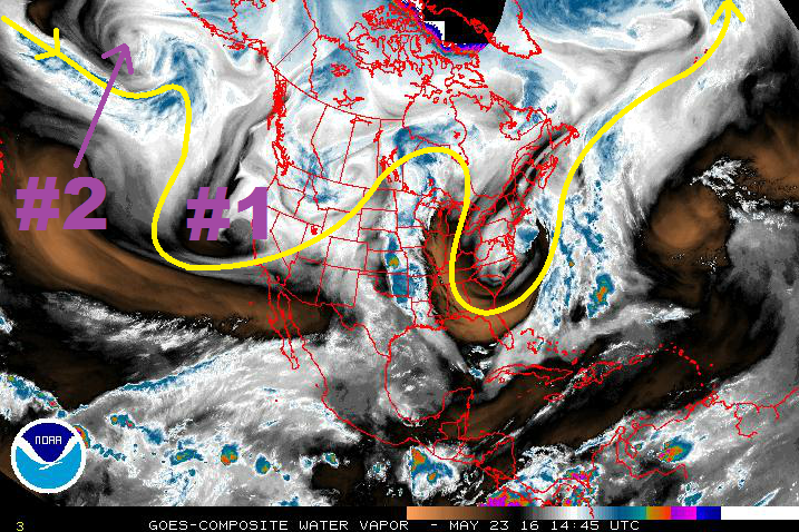
Looking at the water vapor image below, it is fairly easy to pick out the two events highlighted in this edition of the FTO. Event #1 is a short duration event, brought on by a passing upper-level trough. Event #2, on the other hand, opens up an extended period where daily threats will need to be assessed thanks to a persistent West Coast trough and stalled mid-/upper-level low.
Prior to Event #1, severe weather will make a return to northeast and far eastern Colorado on Tuesday. A surface low will develop over southeastern CO/western KS, with flow around the center bringing moisture back into northeastern Colorado. Daytime heating will contribute to the development of strong instability, especially near the eastern border where CO, KS, and NE all meet. A Denver Cyclone will be in place, providing a local enhancement/convergence to thunderstorm development. The main threats will be large hail and damaging winds, including a couple tornadoes. The flood threat will be assessed tomorrow, hinging on how much moisture can move back into Colorado and the expected storm motions.
Event #1 will take place on Thursday (5/26) and Friday (5/27), as the upper-level low/trough slides to the east, moving across the 4-corners first, then across Colorado and over the Central US Plains. Broad scale lift aloft will overspread low-level moisture across Eastern Colorado. Easterly, upslope flow will bring the best chance of precipitation, including localized heavy rain, to the southern Front Range, Southeast Mountains, southern Urban Corridor, Palmer Ridge, and Southeast Plains.
For Event #2, a shortwave associated with the long-wave trough will move into the Pacific Northwest on Saturday (5/28), bringing south-southwesterly flow aloft back to Colorado. This trough-ing along the West Coast becomes persistent, being reinforced by shortwave troughs that round the base of the trough and eject across Colorado. These shortwaves will bring “bursts” of upper-level support for scattered thunderstorm development. The end of Event #2 will be brought on by its own reinforcements. By Wednesday (6/1), a stronger, upper-level low will dig into the Pacific Northwest, deepening the persistent trough. This low will then stall over the Great Basin before opening up and lifting to the northeast on Sunday (6/5), well north of Colorado. The introduction of the strong upper-low will deepen the upper-level trough, allowing the upper-level ridge across the central US to retrograde westward. The presence of the ridge will introduce a warming and drying trend that will look to continue through the remainder of the period.
Event #1: Thursday (05-26-2016) and Friday (05-27-2016)
Elevated Flood Threat as Upslope Flow Pools Moisture near Mountains
The upper-level low/trough will slide to the east, introducing broad scale lift aloft overtop low-level moisture across Eastern Colorado. Easterly, upslope flow will bring the best chance of precipitation, including localized heavy rain, to the southern Front Range, Southeast Mountains, southern Urban Corridor, Palmer Ridge, and Southeast Plains. Stay tuned to the daily FTB.

Event #2: Saturday (05-28-2016) through Wednesday (06-01-2016)
Elevated Flood Threat as Low-Level Moisture Increases across Eastern Colorado
South-southwesterly flow aloft will return to Colorado as an upper-level trough moves back into the Pacific Northwest. The persistent trough-ing will be reinforced by shortwave troughs that round the base of the trough and eject across Colorado. These shortwaves will bring “bursts” of upper-level support for scattered thunderstorm development, while High pressure over the central US transports low-level moisture back into eastern Colorado. This period has the early looks of an active severe weather period for eastern Colorado, especially the eastern Plains, so stay tuned. An update to this period will be provided in Thursday’s FTO.