FTO 07-28-2016: Potential for the First High Threat of 2016 Shows up for Event #3

Issue Date: 7/28/2016
Issue Time: 1:30 PM

Threat_Timeline_20160728

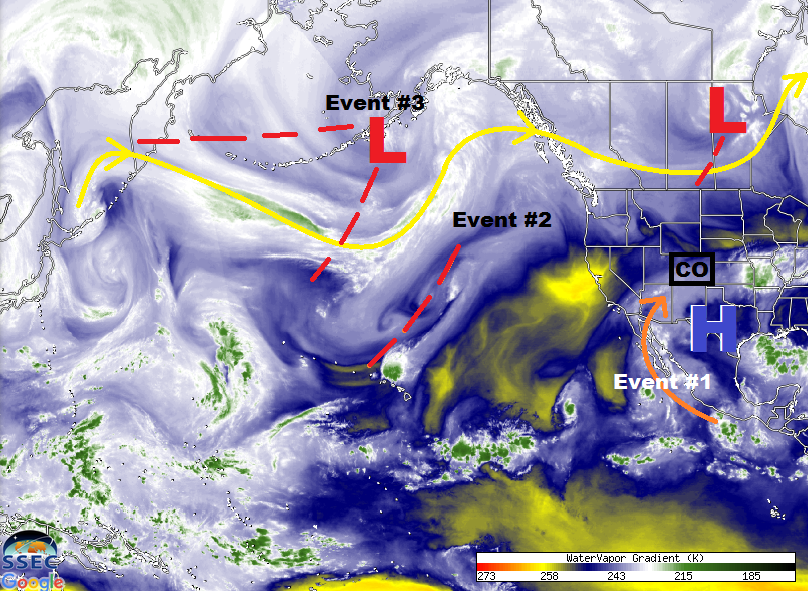
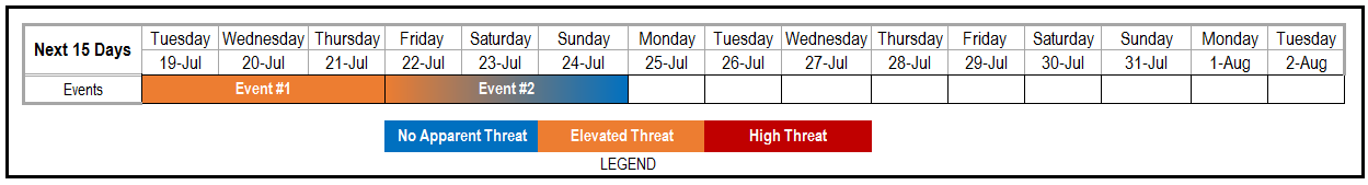
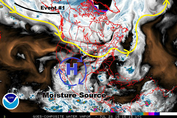
Three events await Colorado over the next fifteen days, with two main culprits at which to point. The first culprit is the upper-level trough denoted as Event #1 in the water vapor image below. Within this trough, there are multiple low pressure circulations, and this will allow for the more poleward circulation to split from the main trough and become embedded in the main flow channel aloft. This will flatten the ridge, provide a shortwave disturbance to focus Event #1’s flood threat on Friday, and then exit to the east in a generally quick fashion. The more equatorward disturbance will instead dig along the West Coast and set the stage for Event #2, the early stages of the next monsoon surge. Event #2 receives no flood threat designation at this time, as there isn’t enough indication of a widespread heavy rain event. That doesn’t mean a flood threat will not present itself during the FTB, so stay tuned to daily updates.

WV_20160728

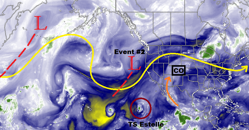
Event #2 can be described as the precursory event to the main monsoon surge associated with Event #3 – the big show in this Flood Threat Outlook period. An influx of deep moisture from the south/southwest looks increasingly likely, providing plenty of fuel for multiple days of showers and thunderstorms capable of heavy rainfall. This is a fairly typical monsoon setup for August, and we have our eyes on it. We will continue to monitor this period as we move forward in time. After Event #3, the monsoon will slowly subside, leading to generally less coverage throughout the rest of the period. Temperatures will heat up during this time frame, likely above average for many locations, but such is August weather in Colorado.

Event #1: Friday (07-29-2016)

Elevated Flood Threat as Upslope Flow Reinforces Moisture

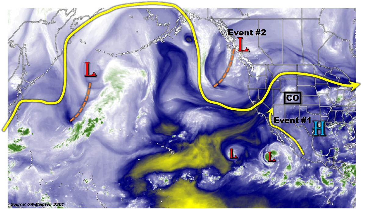
The upper-level high will get pushed eastward as the upper-level low digs along the West Coast, which will help a little extra mid-level moisture work its way into Colorado. Meanwhile, at the surface, upslope flow behind a cool front will reinforce moisture across eastern Colorado. This moisture influx will set the stage for a shortwave aloft to kick off scattered showers/thunderstorms across the Front Range/Southeast Mountains, working across the adjacent lower elevation. A moderately capped environment will exist across the far eastern plains, so expect less coverage there. Out west, it will remain dry and hot.

Legend

Event #2: Sunday (07-31-2016) through Wednesday (08-03-2016)

No Apparent Flood Threat as we Await More Details

Monsoon moisture will begin to increase across the state underneath the building ridge aloft, while a mid-/upper-level low spins over/near the Pacific NW. The moisture tap will not quite get unleashed, remaining steady or only slightly increasing each day. Pinning down the exact location of any disturbance aloft will be key in identifying any developing flood threats, but, at this time, there isn’t enough indication of a widespread heavy rain event to require a flood threat. We will watch this time frame closely in case moisture, instability, or upper-level support are better than currently advertised.

Legend

Event #3: Thursday (08-04-2016) through Tuesday (08-09-2016)

Elevated Flood Threat as Monsoon Tap Opens Up

The monsoon moisture tap will really open up during this time frame, with deep south-southwesterly flow aloft across the region. This influx in deep moisture will look to bring about a widespread heavy rain threat for multiple days. The longer the moisture tap remains open, the more concerning this period may potentially become due to antecedent conditions. This period may require an upgrade to high threat as details become clearer over the next few days. Stay tuned.

Legend

FTO 07-25-2016: Elevated Flood Threat in Short-term, Extended Wet Period Awaiting?

Issue Date: 7/25/2016
Issue Time: 1:32 PM

Threat_Timeline_20160725

For Tuesday (Event #1), the upper-level ridge over the Desert Southwest will continue to rebound and build across the region. However, residual/monsoonal moisture (orange arrow in WV image below), and weak west/northwest flow aloft (while waiting on the ridge to rebound) will keep showers and thunderstorms in the forecast. Activity will be isolated over the mountains and widely scattered over the plains, similar to today’s FTB forecast. There will be sufficient instability and wind shear to produce a few isolated strong-to-severe thunderstorms, especially over the Northeast Plains. These storms will continue to have the threat of heavy rain, thus the “elevated” flood threat tag. Stay tuned to tomorrow’s FTB for more specific information.

Event #2, marked in the water vapor image below, is a shortwave disturbance that will push across the Northern Rockies on Thursday/Friday. At the surface, a cool front will push southward across eastern Colorado. This will allow for low-level moisture to move back into the plains, and perhaps back into the Front Range foothills. At this time, it looks like instability and wind shear will be sufficient for a couple strong/severe storms over the plains. With deepening low-level moisture behind the front with upslope flow, the threat for heavy rain will exist, thus the “elevated” flood threat designation. After Event #2, there will be a short break before the beginning of Event #3. During this break, typical summertime weather is expected as residual moisture and sunshine/orographic influences will promote isolated thunderstorms over the mountains and adjacent valleys/plains.

WV_20160725

Event #3 was discussed during the previous two FTO’s as a possibility, and it is beginning to come into focus. The upper-level low (and multiple shortwave troughs associated with it) will move into the Pacific Northwest by Sunday, July 31. The flow aloft will turn southwest across Colorado, bringing the next surge of monsoonal moisture. At the same time, the upper-level low will eject disturbances across the region, although their exact timing and placement are still uncertain. Also uncertain, but equally important, will be the placement of the high pressure center over the central US. Too far north and west, and the best moisture will miss Colorado and a dry period will ensue. If it slides far enough to the south and east, then deep moisture will overspread Colorado, and it will be an extended wet period with multiple days of flood threats. This will continue to be monitored, so please stay tuned for more information in Thursday’s FTO.

Event #1: Tuesday (07-26-2016)

Elevated Flood Threat as Ridge Rebounds

Residual/monsoonal moisture and weak west/northwest flow aloft will keep isolated-to-widely scattered showers and thunderstorms in the forecast. There will be enough instability and wind shear to organize a couple isolated strong-to-severe storms across the Northeast Plains. The threat of heavy rain is still present, and antecedent conditions are a concern in some areas. Stay tuned to tomorrow’s FTB for updated information.

Legend

Event #2: Thursday (07-28-2016) and Friday (07-29-2016)

Elevated Flood Threat as a Shortwave and Cool Front Join Forces

A shortwave disturbance will push across the Northern Rockies on Thursday/Friday. At the surface, a cool front will push southward across eastern Colorado, allowing low-level moisture to return to the plains, and perhaps back into the Front Range foothills. Instability and wind shear will likely be sufficient for a couple strong/severe storms over the plains. Local details will be of utmost importance in the location of the flood threat, so stay tuned to the FTB for each day.

Legend

FTO 07-21-2016: Wet and Unsettled to Start, Then the Heat Returns

Issue Date: 7/21/2016
Issue Time: 10:00 AM

Threat_Timeline_20160721

It has been an active past week or so with the first big surge of monsoonal moisture, bringing beneficial rain to many locations that were experiencing dry and hot conditions. With the moisture, Mother Nature helped bring an end to the streak of enhanced fire danger that gripped the High Country and Western Slope which resulted in a number of wildfires. You can see the monsoonal moisture surge being pulled from deep within the subtropics on the water vapor image below (orange arrow). This moisture stream will continue to flow into Colorado for one more day (Friday) before being shunted to the west as the upper-ridge flattens under the influence of Event #2 (denoted below).

As the upper-level shortwave marked “Event #2” moves across the northern US, it will usher a surface cold front across eastern Colorado on Saturday morning, resulting in moist, easterly upslope flow by Saturday afternoon. This will bring scattered-to-widespread showers and thunderstorms to the eastern mountains and plains, with locally heavy rainfall likely under stronger storms. Not much change to this pattern will occur through Sunday, keeping the flood threat elevated through the weekend.

WV_20160721

By Monday and Tuesday, the upper-level ridge that had been flattened over the Desert Southwest will begin to rebound and build across the region. However, residual moisture and weak west/northwest flow aloft (while waiting on the ridge to rebound) will keep showers and thunderstorms in the forecast, mainly over the Front Range and northeast Colorado. The Southeast Plains and far western Colorado will be the first regions to see the moisture shut off. This reduction in moisture/storms due to the rebounding of the ridge is represented by the gradient of “Elevated” to “No Apparent Threat” in the flood threat timeline above. After Event #2, Colorado will return to the dry and hot conditions for about a week or so. The unfortunate side to the dry and hot period will be the return of fire danger.

Event #3 was alluded to during the previous FTO discussion on Monday, as Dima wrote: “[T]here is only a loose indication that the ridge will cede its position to another monsoonal surge at the tail end of this forecast period.” Ensembles continue to hint at the ridge sliding to the east, re-centering over the central US, and turning back on the monsoonal moisture tap by the end of this period (August 2nd – August 5th). Uncertainty remains surrounding this outcome, so there will not be an event discussion generated below. Stay tuned for the next FTO on Monday for an update.

Event #1: Friday (07-22-2016)

Elevated Flood Threat for Monsoonal Moisture’s Final Stand (For Now)

Before the upper-ridge becomes flattened, it will bring one more day of good monsoonal moisture to Colorado. Scattered-to-widespread showers/thunderstorms are expected across the High Country and Western Slope, with storms moving to the east/northeast across eastern Colorado, driven by the mean flow aloft. Locally heavy rainfall under thunderstorms is likely, especially concerning for areas that have seen repeated rounds of rainfall the last few days. Debris/mud flows and rock slides will be a concern for steeper terrain areas. The outlined area in the precipitation map below depicts the 0.5-1.0 inch range, but one or two locations within the area may receive more than that. Stay tuned to the FTB forecast tomorrow.

Legend

Event #2: Saturday (07-23-2016) through Tuesday (07-26-2016)

Elevated Flood Threat as Surface Cold Frontal Passage Brings Upslope Flow

A surface cold front will be ushered across eastern Colorado on Saturday morning as the upper-level shortwave passes across the northern US. This will result in moist, easterly upslope flow by Saturday afternoon, pooling deep moisture along the eastern mountains and across the plains. Scattered-to-widespread showers and thunderstorms are expected for the eastern mountains and plains, with locally heavy rainfall likely under stronger storms. Meanwhile, residual moisture will keep diurnal showers/thunderstorms active across much of the High Country/Western Slope. Not much change to the pattern is expected through the weekend, with the flood threat diminishing moving through Monday and Tuesday.

Legend

FTO 07-18-2016: Monsoon Flow Early, Then Dry And (Very?) Hot

Issue Date: Monday, July 18th, 2016
Issue Time: 3:00PM MDT
Valid Period: July 19th – August 2nd

threat_timelineThe big news in this Flood Threat Outlook is the welcome arrival of 2016’s first large-scale monsoonal surge. It came just in time, as parts of the Continental Divide and Western Slope had endured a significant patch of dry weather. At least half a dozen wildfires popped up around the state as a result of this. As shown in the water vapor image, below, the monsoonal surge is originating from deep in the subtropics along the western Mexican coastline. It may even be indirectly aided by outflow from Tropical Storm Estelle (the easternmost “L” in the map below), which will likely become a hurricane before dissipating far out at sea. The monsoonal surge (Event #1) is expected to last for the next 72 hours and will impact mostly the Western Slope. However, the disturbance currently off the northwest coast (Event #2) could then drag a Pacific cool front across the northern Rockies and provide another few days of heavy rainfall east of the Divide. However, this is far from guaranteed at the moment, hence its classification as an Elevated Threat transitioning to a No Apparent Threat.

wv_markup

Unfortunately, it does not look like this wet surge of weather will break the overall drier pattern seen during June and July. The set of maps below show the forecasted pattern anomaly centered on next Tuesday, 7/26. A large-scale, moderate strength ridge will once again re-establish itself in the northern Rocky Mountain states possibly stretching southwest off the California coast and northeast towards northeastern North America. Such a ridge position is not conducive to widespread rainfall across Colorado (i) because it blocks off the southerly monsoonal flow mainly across the Western Slope, and (ii) because it prevents northwest flow disturbance from impacting the eastern Plains. Accordingly, Precipitable Water and precipitation are both below normal during this kind of regime (note the precipitation colorbar is flipped: positive values are purple). There are some indications that this ridge will rapidly strengthen which could several days of extremely hot and dry weather. At this time, there is only a loose indication that the ridge will cede its position to another monsoonal surge at the tail end of this forecast period (August 1 – 2). At this time, there is far from enough confidence to label this an event.

analogs_6_10Below, we describe the two identified events in more detail.

Event #1: Tuesday (7/19) through Thursday (7/21)

An Elevated Flood Threat mainly west of the Divide as monsoonal pulses flow north

Daily pulses of monsoonal moisture will flow northward out of Mexico and the eastern tropical Pacific, providing widespread parts of the western slope with shower and thunderstorm activity. At this time, the event looks to be spread out enough in space and time that only an elevated threat is needed. We anticipate many regions tallying over 1 inch of rainfall, with climatologically favored parts of the San Juan mountains tallying closer to 2 inches. With this much rainfall, isolated flash flooding will be possible, along with debris slides and mud flows especially over particularly parched terrain. Each day, part of this activity will make it over the Continental Divide and provide isolated to scattered storms for northeast Colorado. However, storms will have a difficult time sustaining themselves under the strong ridge positioned to the southeast. Thus, only sub-flood threat level rainfall up to 1 inch is expected for eastern areas.

Legend

Event #2: Friday (7/22) through Sunday (7/24)

An initially Elevated Flood Threat followed by less certain chances of heavy rainfall

The monsoonal push will wind down as the ridge expands westward and turns the steering winds westerly, causing substantial drying. However, there is enough consensus that the large-scale disturbance currently off the northwest US coast will slowly propagate east and make it over the Rocky Mountains. This will be followed by a cool front passage, which will bring plenty of residual moisture east of the Divide. This time of year, moisture alone is usually enough for a heavy rainfall threat. Thus, we expect that Friday will see a round of heavy rainfall across the Plains. Up to 1.5 inches will be possible with the storms, leading to isolated flash flooding, roadway and field flooding. Severe weather is not expected at this time due to warm upper-level temperatures and weak shear. The flow turns more uncertain by Saturday and Sunday when it is unclear if enough moisture will remain to cause widespread heavy rainfall. At this time, we are marking this as a No Apparent Threat, though it is possible this may need to be upgraded for the next FTO.

Legend