Issue Date: Monday, July 18th, 2016
Issue Time: 3:00PM MDT
Valid Period: July 19th – August 2nd
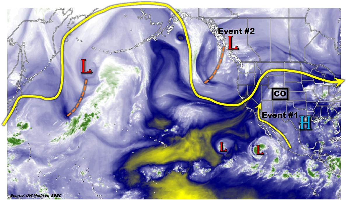
 The big news in this Flood Threat Outlook is the welcome arrival of 2016’s first large-scale monsoonal surge. It came just in time, as parts of the Continental Divide and Western Slope had endured a significant patch of dry weather. At least half a dozen wildfires popped up around the state as a result of this. As shown in the water vapor image, below, the monsoonal surge is originating from deep in the subtropics along the western Mexican coastline. It may even be indirectly aided by outflow from Tropical Storm Estelle (the easternmost “L” in the map below), which will likely become a hurricane before dissipating far out at sea. The monsoonal surge (Event #1) is expected to last for the next 72 hours and will impact mostly the Western Slope. However, the disturbance currently off the northwest coast (Event #2) could then drag a Pacific cool front across the northern Rockies and provide another few days of heavy rainfall east of the Divide. However, this is far from guaranteed at the moment, hence its classification as an Elevated Threat transitioning to a No Apparent Threat.
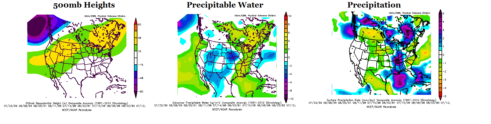
Unfortunately, it does not look like this wet surge of weather will break the overall drier pattern seen during June and July. The set of maps below show the forecasted pattern anomaly centered on next Tuesday, 7/26. A large-scale, moderate strength ridge will once again re-establish itself in the northern Rocky Mountain states possibly stretching southwest off the California coast and northeast towards northeastern North America. Such a ridge position is not conducive to widespread rainfall across Colorado (i) because it blocks off the southerly monsoonal flow mainly across the Western Slope, and (ii) because it prevents northwest flow disturbance from impacting the eastern Plains. Accordingly, Precipitable Water and precipitation are both below normal during this kind of regime (note the precipitation colorbar is flipped: positive values are purple). There are some indications that this ridge will rapidly strengthen which could several days of extremely hot and dry weather. At this time, there is only a loose indication that the ridge will cede its position to another monsoonal surge at the tail end of this forecast period (August 1 – 2). At this time, there is far from enough confidence to label this an event.
 Below, we describe the two identified events in more detail.
Event #1: Tuesday (7/19) through Thursday (7/21)
An Elevated Flood Threat mainly west of the Divide as monsoonal pulses flow north
Daily pulses of monsoonal moisture will flow northward out of Mexico and the eastern tropical Pacific, providing widespread parts of the western slope with shower and thunderstorm activity. At this time, the event looks to be spread out enough in space and time that only an elevated threat is needed. We anticipate many regions tallying over 1 inch of rainfall, with climatologically favored parts of the San Juan mountains tallying closer to 2 inches. With this much rainfall, isolated flash flooding will be possible, along with debris slides and mud flows especially over particularly parched terrain. Each day, part of this activity will make it over the Continental Divide and provide isolated to scattered storms for northeast Colorado. However, storms will have a difficult time sustaining themselves under the strong ridge positioned to the southeast. Thus, only sub-flood threat level rainfall up to 1 inch is expected for eastern areas.

Event #2: Friday (7/22) through Sunday (7/24)
An initially Elevated Flood Threat followed by less certain chances of heavy rainfall
The monsoonal push will wind down as the ridge expands westward and turns the steering winds westerly, causing substantial drying. However, there is enough consensus that the large-scale disturbance currently off the northwest US coast will slowly propagate east and make it over the Rocky Mountains. This will be followed by a cool front passage, which will bring plenty of residual moisture east of the Divide. This time of year, moisture alone is usually enough for a heavy rainfall threat. Thus, we expect that Friday will see a round of heavy rainfall across the Plains. Up to 1.5 inches will be possible with the storms, leading to isolated flash flooding, roadway and field flooding. Severe weather is not expected at this time due to warm upper-level temperatures and weak shear. The flow turns more uncertain by Saturday and Sunday when it is unclear if enough moisture will remain to cause widespread heavy rainfall. At this time, we are marking this as a No Apparent Threat, though it is possible this may need to be upgraded for the next FTO.