Issue Date: 7/21/2016
Issue Time: 10:00 AM

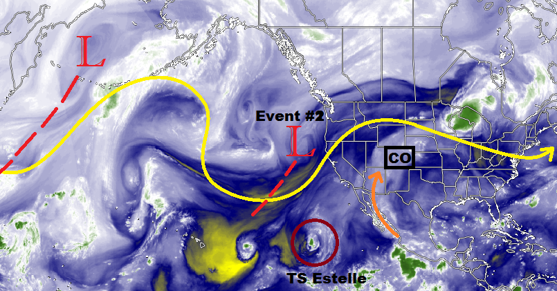
It has been an active past week or so with the first big surge of monsoonal moisture, bringing beneficial rain to many locations that were experiencing dry and hot conditions. With the moisture, Mother Nature helped bring an end to the streak of enhanced fire danger that gripped the High Country and Western Slope which resulted in a number of wildfires. You can see the monsoonal moisture surge being pulled from deep within the subtropics on the water vapor image below (orange arrow). This moisture stream will continue to flow into Colorado for one more day (Friday) before being shunted to the west as the upper-ridge flattens under the influence of Event #2 (denoted below).
As the upper-level shortwave marked “Event #2” moves across the northern US, it will usher a surface cold front across eastern Colorado on Saturday morning, resulting in moist, easterly upslope flow by Saturday afternoon. This will bring scattered-to-widespread showers and thunderstorms to the eastern mountains and plains, with locally heavy rainfall likely under stronger storms. Not much change to this pattern will occur through Sunday, keeping the flood threat elevated through the weekend.
By Monday and Tuesday, the upper-level ridge that had been flattened over the Desert Southwest will begin to rebound and build across the region. However, residual moisture and weak west/northwest flow aloft (while waiting on the ridge to rebound) will keep showers and thunderstorms in the forecast, mainly over the Front Range and northeast Colorado. The Southeast Plains and far western Colorado will be the first regions to see the moisture shut off. This reduction in moisture/storms due to the rebounding of the ridge is represented by the gradient of “Elevated” to “No Apparent Threat” in the flood threat timeline above. After Event #2, Colorado will return to the dry and hot conditions for about a week or so. The unfortunate side to the dry and hot period will be the return of fire danger.
Event #3 was alluded to during the previous FTO discussion on Monday, as Dima wrote: “[T]here is only a loose indication that the ridge will cede its position to another monsoonal surge at the tail end of this forecast period.” Ensembles continue to hint at the ridge sliding to the east, re-centering over the central US, and turning back on the monsoonal moisture tap by the end of this period (August 2nd – August 5th). Uncertainty remains surrounding this outcome, so there will not be an event discussion generated below. Stay tuned for the next FTO on Monday for an update.
Event #1: Friday (07-22-2016)
Elevated Flood Threat for Monsoonal Moisture’s Final Stand (For Now)
Before the upper-ridge becomes flattened, it will bring one more day of good monsoonal moisture to Colorado. Scattered-to-widespread showers/thunderstorms are expected across the High Country and Western Slope, with storms moving to the east/northeast across eastern Colorado, driven by the mean flow aloft. Locally heavy rainfall under thunderstorms is likely, especially concerning for areas that have seen repeated rounds of rainfall the last few days. Debris/mud flows and rock slides will be a concern for steeper terrain areas. The outlined area in the precipitation map below depicts the 0.5-1.0 inch range, but one or two locations within the area may receive more than that. Stay tuned to the FTB forecast tomorrow.

Event #2: Saturday (07-23-2016) through Tuesday (07-26-2016)
Elevated Flood Threat as Surface Cold Frontal Passage Brings Upslope Flow
A surface cold front will be ushered across eastern Colorado on Saturday morning as the upper-level shortwave passes across the northern US. This will result in moist, easterly upslope flow by Saturday afternoon, pooling deep moisture along the eastern mountains and across the plains. Scattered-to-widespread showers and thunderstorms are expected for the eastern mountains and plains, with locally heavy rainfall likely under stronger storms. Meanwhile, residual moisture will keep diurnal showers/thunderstorms active across much of the High Country/Western Slope. Not much change to the pattern is expected through the weekend, with the flood threat diminishing moving through Monday and Tuesday.