Issue Date: 7/25/2016
Issue Time: 1:32 PM

For Tuesday (Event #1), the upper-level ridge over the Desert Southwest will continue to rebound and build across the region. However, residual/monsoonal moisture (orange arrow in WV image below), and weak west/northwest flow aloft (while waiting on the ridge to rebound) will keep showers and thunderstorms in the forecast. Activity will be isolated over the mountains and widely scattered over the plains, similar to today’s FTB forecast. There will be sufficient instability and wind shear to produce a few isolated strong-to-severe thunderstorms, especially over the Northeast Plains. These storms will continue to have the threat of heavy rain, thus the “elevated” flood threat tag. Stay tuned to tomorrow’s FTB for more specific information.
Event #2, marked in the water vapor image below, is a shortwave disturbance that will push across the Northern Rockies on Thursday/Friday. At the surface, a cool front will push southward across eastern Colorado. This will allow for low-level moisture to move back into the plains, and perhaps back into the Front Range foothills. At this time, it looks like instability and wind shear will be sufficient for a couple strong/severe storms over the plains. With deepening low-level moisture behind the front with upslope flow, the threat for heavy rain will exist, thus the “elevated” flood threat designation. After Event #2, there will be a short break before the beginning of Event #3. During this break, typical summertime weather is expected as residual moisture and sunshine/orographic influences will promote isolated thunderstorms over the mountains and adjacent valleys/plains.
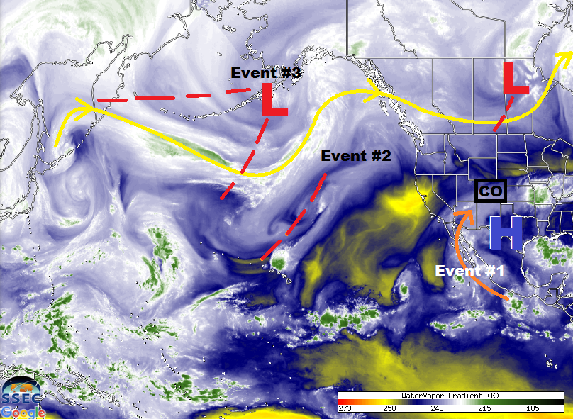
Event #3 was discussed during the previous two FTO’s as a possibility, and it is beginning to come into focus. The upper-level low (and multiple shortwave troughs associated with it) will move into the Pacific Northwest by Sunday, July 31. The flow aloft will turn southwest across Colorado, bringing the next surge of monsoonal moisture. At the same time, the upper-level low will eject disturbances across the region, although their exact timing and placement are still uncertain. Also uncertain, but equally important, will be the placement of the high pressure center over the central US. Too far north and west, and the best moisture will miss Colorado and a dry period will ensue. If it slides far enough to the south and east, then deep moisture will overspread Colorado, and it will be an extended wet period with multiple days of flood threats. This will continue to be monitored, so please stay tuned for more information in Thursday’s FTO.
Event #1: Tuesday (07-26-2016)
Elevated Flood Threat as Ridge Rebounds
Residual/monsoonal moisture and weak west/northwest flow aloft will keep isolated-to-widely scattered showers and thunderstorms in the forecast. There will be enough instability and wind shear to organize a couple isolated strong-to-severe storms across the Northeast Plains. The threat of heavy rain is still present, and antecedent conditions are a concern in some areas. Stay tuned to tomorrow’s FTB for updated information.

Event #2: Thursday (07-28-2016) and Friday (07-29-2016)
Elevated Flood Threat as a Shortwave and Cool Front Join Forces
A shortwave disturbance will push across the Northern Rockies on Thursday/Friday. At the surface, a cool front will push southward across eastern Colorado, allowing low-level moisture to return to the plains, and perhaps back into the Front Range foothills. Instability and wind shear will likely be sufficient for a couple strong/severe storms over the plains. Local details will be of utmost importance in the location of the flood threat, so stay tuned to the FTB for each day.