FTO 08-11-2016: Two Events in the First 11 Days

Issue Date: 8/11/2016
Issue Time: 1:07 PM

Threat_Timeline_20160811

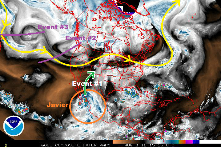
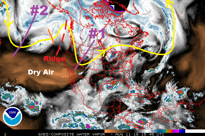
Current water vapor analysis (below) shows the key features with regards to this edition of the FTO. Event #1 is currently underway (Thursday was highlighted as the beginning to this event in Monday’s FTO), and will continue through Saturday as the upper-trough (marked by the purple line, #1) sweeps across the northern US. The trough is in the process of pushing a cool front through the state today, and behind it will be the return of upslope flow. This will provide a slight uptick in low-level moisture for eastern Colorado on Friday, as well as enhance wind shear, leading to the return of organized convection, with a few storms on the strong/severe side. For Saturday, more thunderstorms are in the forecast, although a downtick in coverage and intensity is expected due to lesser instability/shear values, as well as slightly less moisture.

For western Colorado, the drier air that is noted in the water vapor image will continue to push in as the upper-level ridging (red dashes) builds aloft, subduing the majority of convection. A few isolated showers/thunderstorms will pop up over the higher terrain, working on residual moisture and orographic effects. Overall, the area will be mainly dry, with mostly sunny skies dominating a majority of the region.

WV_20160811

After Event #1, a drier period will take hold of Colorado as upper-ridging builds aloft and precipitable water values fall due to the influx of drier air. Isolated showers and garden variety thunderstorms will develop over the higher terrain due to daytime heating and orographic effects, resulting in mainly gusty winds and light rainfall. A weak disturbance threatens to break up the dry pattern on Tuesday/Wednesday (orange line), but it remains to be seen where its eventual path will take it. At this time, it looks to pass too far north and east to bring meaningful precipitation to Colorado, but it needs monitoring.

Event #2 will be associated with the upper-level trough marked on the water vapor image above. Currently, the timing for its impacts to reach Colorado will be Friday, August 19th. No flood threat is apparent at this time as there is too much uncertainty regarding its eventual path and the amount of moisture that can return ahead of it. Much will depend on the eventual movement/placement of the upper-level high pressure center, and whether or not monsoonal flow will make a return. Models have been wishy-washy, which reduces our confidence in any particular outcome. Stay tuned to Monday’s FTO for more on this time frame.

Event #1: Friday (08-12-2016) and Saturday (08-13-2016)

Elevated Flood Threat due to Upslope Flow and Potential for Stronger Thunderstorms

Behind the cool front of today will be the return of upslope flow. Due to this, an uptick in wind shear, instability, and moisture is expected, which will lead to more organized convection across eastern Colorado. A few storms will be on the strong/severe side of the scale, producing strong winds, hail, and locally heavy rainfall. For Saturday, a slight downtick in coverage and intensity is expected, but the flood threat will continue, mainly for southeastern Colorado.

Legend

Event #2: Friday (08-19-2016) through Monday (08-22-2016)

No Apparent Flood Threat as Details Remain “Cloudy”

Event #2 is associated with the next upper-level trough poised to swing across the western United States. No flood threat is apparent at this time as there is too much uncertainty regarding its eventual path and the amount of moisture that can return ahead of it. Much will depend on smaller-scale features not evident at this time, including the development of any cool fronts/lee side troughs, monsoonal flow returning, and any other small-scale disturbances in the flow. Not helping matters is that models have been wishy-washy of late, which reduces our confidence in any particular outcome. The precipitation map below represents our latest best thinking, but be aware that it will likely be adjusted as we move forward. Stay tuned to Monday’s FTO for more on this time frame.

Legend

FTO 08-08-2016: Two Events Early, then Drier Period

Issue Date: 8/8/2016
Issue Time: 1:02 PM

Threat_Timeline_20160808

The monsoon has been in high gear to start the month of August, with most days being marked by showers and thunderstorms producing periods of heavy rainfall. This was especially true across southern and southwestern Colorado where the deepest moisture settled most often. Events #1 and #2 in this period will look to address that with a bit more moisture being pulled northward, spreading the wealth of rainfall, so to speak. Without any further ado, let’s jump right into the forecast.

Current water vapor analysis tells this FTO story well, with all 3 events on the horizon being noted in this afternoon’s imagery. Event #1 is the next monsoon surge, courtesy of subtropical moisture ahead of Tropical Storm Javier (orange circle). This surge in moisture will bring an uptick in showers and thunderstorms, mainly over the mountains on Wednesday. Areas that have received plenty of rainfall recently, namely the Southwest Slope and San Juan Mountains, will be at the most risk, relatively speaking, for flooding issues. These details will be fine-tuned by the FTB on Wednesday, so stay tuned to that.

WV_20160808

Event #2 will begin to impact the area on Thursday, as dynamics ahead of the upper-level trough provide broad-scale support for showers and thunderstorms. At the same time, a cold front will move southeastward across Colorado, forcing a few showers/thunderstorms as it passes through. Behind it, however, is the bigger story of upslope flow. This will provide an uptick in low-level moisture, as well as enhance wind shear, leading to the return of organized convection, with a few storms on the strong/severe side. Friday and Saturday, as the upper-level trough passes to the east, expect the air mass to gradually dry out from west to east, with fewer storms each day. After Event #2, an upper-level ridge will build in ahead of Event #3, leading to a drier period overall. Aside from a few weaker thunderstorms over the higher terrain that can make the most of residual moisture and orographic effects, much of the state will remain mostly sunny and dry, especially over far eastern Colorado.
Event #3 will be associated with the upper-level disturbance/trough marked on the water vapor image above. Currently, the timing for its impacts to reach Colorado will be Sunday, August 21st. No flood threat is apparent at this time as there is too much uncertainty regarding its eventual path and the amount of moisture that can return ahead of it. For that reason, no event discussion will be issued below. Stay tuned to Thursday’s FTO for more on this time frame.

Event #1: Wednesday (08-10-2016)

Elevated Flood Threat due to Subtropical Moisture Surge

Before the next upper-level trough can move into the region, a subtropical moisture surge from the southwest will bring an increase in showers/thunderstorms. Much of this increase will be felt over the mountains, but a few storms will work across the lower elevations of eastern Colorado, as well. Antecedent conditions from previous rainfall is a concern across southwestern Colorado, especially in the steep terrain.

Legend

Event #2: Thursday (08-11-2016) through Saturday (08-13-2016)

Elevated Flood Threat as Upper-Level Trough Slides Through

The first impacts from Event #2 will be felt on Thursday, as broad-scale support fills in overhead with the approach of the upper-level trough. Meanwhile, at the surface, a cold front will move across the state, forcing a few showers/thunderstorms as it passes through. Behind it, upslope flow will provide an uptick in low-level moisture, fueling more efficient rainfall. Additionally, enhanced wind shear due to the change in surface wind direction will result in more organized convection, with a few storms becoming strong/severe. As the upper-level trough continues to pass to the east on Friday and Saturday, each day will result in fewer storms as the air mass gradually dries out from west to east.

Legend

FTO 08-04-2016: High Threat Continues, Followed By Drier Period

Issue Date: 8/4/2016
Issue Time: 1:00 PM

Threat_Timeline_20160804

The High Threat that was issued on Monday for Event #1 continues in this edition of the FTO. The increase in monsoonal moisture has been substantial, with Grand Junction’s IPW value reaching towards 1.4 inches this afternoon. The three other reporting stations that are frequently referenced in the FTB (Boulder, Schriever AFB, and Pueblo) all continue to sit near 1 inch. Those values are expected to increase this evening as the moisture surge continues to the east-northeast.

IPW_20160804

Multiple shortwave disturbance continue to be noted in the water vapor imagery (purple line) while subtle disturbances embedded in the monsoonal flow (green arrow) continue to round the ridge into the region. These disturbances provide broad-scale support for showers and thunderstorms, while the deep moisture provides the fuel necessary for efficient rainfall. The monsoonal tap will remain open through Event #1, with the height of the moisture/flooding threat being Friday and Saturday. More on this situation in the event discussions below.

WV_20160804

The state will begin to dry out from west-to-east starting late Sunday/early Monday as the flow aloft becomes more westerly, advecting in drier air noted currently to the west. This will cause a downturn in showers and thunderstorms, especially from Tuesday onward, but some diurnal activity driven by orographic influences is still expected. Locally heavy rainfall will be much less of a concern during this period, which is why no event designation is needed.

Event #2 will be a quick hit event occurring late next week; current thinking is next Friday, August 12th. A quick-moving, mid-level disturbance is expected to move across the region as the ridging continues to build overhead, pushing a weak cool front through eastern Colorado. This will allow for moist, upslope flow to make a brief return, bringing the threat of a few strong-to-severe thunderstorms back to eastern Colorado. The areas to watch for this event will be those that are along and east of the Front Range/Southeast Mountains. Event #2 is designated a “No Apparent Flood Threat” event, but we will continue to monitor this event in the coming days. An update will come in the next FTO. After Event #2, ridging is expected to build quickly and decisively, drying out Colorado for the remainder of this FTO period.

Event #1: Friday (08-05-2016) through Sunday (08-07-2016)

High Flood Threat Continues as Deep Moisture Remains Overhead

Shortwave disturbances, both upper-level and mid-level, are expected to continue supporting rounds of scattered-to-widespread showers/thunderstorms over the next few days. Friday and Saturday will be the height of the event before it begins to wind down on Sunday. There is plenty of moisture to fuel efficient rainfall, and antecedent conditions are becoming a concern in steeper terrain areas after heavy rain today and yesterday. Burn scars will need to be watched closely, as well.

Legend

Event #2: Friday (08-12-2016)

No Apparent Threat for Quick-Hitting event

A quick-moving, mid-level disturbance is expected to move across the region as the ridging continues to build overhead, pushing a weak cool front through eastern Colorado. Moist, upslope flow will return as a result for a brief period of time. This will bring the threat of a few strong-to-severe thunderstorms back to eastern Colorado.

Legend

FTO 08-01-2016: First High Threat of the FTO Season for Event #1

Issue Date: 8/01/2016
Issue Time: 1:40 PM

Threat_Timeline_20160801

The first High Threat of this FTO season has been issued for Event #1; a result of increasing monsoonal moisture and multiple shortwave disturbances expected to provide broad-scale support to thunderstorms. If you take a look at the water vapor image below, you can see the disturbances lined up one right after the other (purple lines). The green arrow represents the monsoonal flow that has provided the past couple of days of moisture; this tap will remain open through Event #1, with the height of the moisture/flooding threat being Thursday – Saturday. Locations across southwestern Colorado may receive as much as 2.5-3.0 inches of rain. More on this situation in the event discussions below.

WV_20160801

After Event #1, the state will largely dry out through Wednesday, August 10th. There will still be diurnal showers/thunderstorms driven by orographic influences, and locally heavy rainfall is a possibility, but not on a large enough scale to warrant an event designation in the Flood Threat Outlook. In other words: It will be a stretch of typical Colorado summer days. Event #2 is expected to begin late next week, approx. Thursday, August 11th, continuing until Saturday, August 13th. Monsoon moisture will return as westerly flow aloft turns back southwesterly and opens the tap once again. During this event, the southern half of Colorado will be under the gun for the most rainfall as drier air to the north will work against its northward progression. The Raton Ridge, Southwestern Slope, and San Juan Mountains will be the areas to watch. After Event #2, the atmosphere dries back out as an upper-level trough digs along the West Coast, amplifying the ridge overhead.

Event #1: Wednesday (08-03-2016) through Sunday (08-07-2016)

High Flood Threat as Multiple Disturbances Work on Monsoonal Moisture

Widespread, deeper moisture is expected to overspread Colorado as the monsoonal surge increases through the week. Multiple disturbances aloft will provide broad-scale support for showers/thunderstorms. Instability values will be sufficient for organized thunderstorms, especially over southern zones. The Northeast Plains will have to work to overcome a weak mid-level cap, so expect that region to see the least activity, comparatively speaking.

Legend

Event #2: Thursday (08-11-2016) through Saturday (08-13-2016)

Elevated Flood Threat as the Monsoon Returns

Monsoon moisture will return as westerly flow aloft turns back southwesterly and opens the tap once again. The monsoonal surge will have to battle drier air to the north, likely positioning the best moisture across the southern half of Colorado. As mentioned above, the Raton Ridge, Southeast Mountains, Southwestern Slope, and San Juan Mountains will be the main areas to watch, without discounting adjacent zones to the north.

Legend