Issue Date: 8/4/2016
Issue Time: 1:00 PM

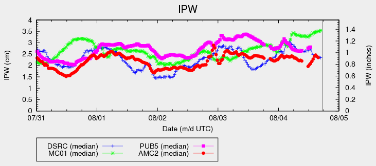
The High Threat that was issued on Monday for Event #1 continues in this edition of the FTO. The increase in monsoonal moisture has been substantial, with Grand Junction’s IPW value reaching towards 1.4 inches this afternoon. The three other reporting stations that are frequently referenced in the FTB (Boulder, Schriever AFB, and Pueblo) all continue to sit near 1 inch. Those values are expected to increase this evening as the moisture surge continues to the east-northeast.
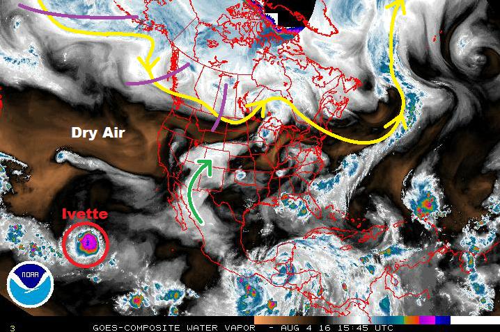
Multiple shortwave disturbance continue to be noted in the water vapor imagery (purple line) while subtle disturbances embedded in the monsoonal flow (green arrow) continue to round the ridge into the region. These disturbances provide broad-scale support for showers and thunderstorms, while the deep moisture provides the fuel necessary for efficient rainfall. The monsoonal tap will remain open through Event #1, with the height of the moisture/flooding threat being Friday and Saturday. More on this situation in the event discussions below.
The state will begin to dry out from west-to-east starting late Sunday/early Monday as the flow aloft becomes more westerly, advecting in drier air noted currently to the west. This will cause a downturn in showers and thunderstorms, especially from Tuesday onward, but some diurnal activity driven by orographic influences is still expected. Locally heavy rainfall will be much less of a concern during this period, which is why no event designation is needed.
Event #2 will be a quick hit event occurring late next week; current thinking is next Friday, August 12th. A quick-moving, mid-level disturbance is expected to move across the region as the ridging continues to build overhead, pushing a weak cool front through eastern Colorado. This will allow for moist, upslope flow to make a brief return, bringing the threat of a few strong-to-severe thunderstorms back to eastern Colorado. The areas to watch for this event will be those that are along and east of the Front Range/Southeast Mountains. Event #2 is designated a “No Apparent Flood Threat” event, but we will continue to monitor this event in the coming days. An update will come in the next FTO. After Event #2, ridging is expected to build quickly and decisively, drying out Colorado for the remainder of this FTO period.
Event #1: Friday (08-05-2016) through Sunday (08-07-2016)
High Flood Threat Continues as Deep Moisture Remains Overhead
Shortwave disturbances, both upper-level and mid-level, are expected to continue supporting rounds of scattered-to-widespread showers/thunderstorms over the next few days. Friday and Saturday will be the height of the event before it begins to wind down on Sunday. There is plenty of moisture to fuel efficient rainfall, and antecedent conditions are becoming a concern in steeper terrain areas after heavy rain today and yesterday. Burn scars will need to be watched closely, as well.

Event #2: Friday (08-12-2016)
No Apparent Threat for Quick-Hitting event
A quick-moving, mid-level disturbance is expected to move across the region as the ridging continues to build overhead, pushing a weak cool front through eastern Colorado. Moist, upslope flow will return as a result for a brief period of time. This will bring the threat of a few strong-to-severe thunderstorms back to eastern Colorado.