Issue Date: 8/01/2016
Issue Time: 1:40 PM
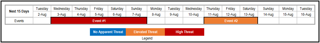
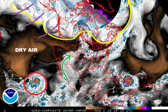
The first High Threat of this FTO season has been issued for Event #1; a result of increasing monsoonal moisture and multiple shortwave disturbances expected to provide broad-scale support to thunderstorms. If you take a look at the water vapor image below, you can see the disturbances lined up one right after the other (purple lines). The green arrow represents the monsoonal flow that has provided the past couple of days of moisture; this tap will remain open through Event #1, with the height of the moisture/flooding threat being Thursday – Saturday. Locations across southwestern Colorado may receive as much as 2.5-3.0 inches of rain. More on this situation in the event discussions below.
After Event #1, the state will largely dry out through Wednesday, August 10th. There will still be diurnal showers/thunderstorms driven by orographic influences, and locally heavy rainfall is a possibility, but not on a large enough scale to warrant an event designation in the Flood Threat Outlook. In other words: It will be a stretch of typical Colorado summer days. Event #2 is expected to begin late next week, approx. Thursday, August 11th, continuing until Saturday, August 13th. Monsoon moisture will return as westerly flow aloft turns back southwesterly and opens the tap once again. During this event, the southern half of Colorado will be under the gun for the most rainfall as drier air to the north will work against its northward progression. The Raton Ridge, Southwestern Slope, and San Juan Mountains will be the areas to watch. After Event #2, the atmosphere dries back out as an upper-level trough digs along the West Coast, amplifying the ridge overhead.
Event #1: Wednesday (08-03-2016) through Sunday (08-07-2016)
High Flood Threat as Multiple Disturbances Work on Monsoonal Moisture
Widespread, deeper moisture is expected to overspread Colorado as the monsoonal surge increases through the week. Multiple disturbances aloft will provide broad-scale support for showers/thunderstorms. Instability values will be sufficient for organized thunderstorms, especially over southern zones. The Northeast Plains will have to work to overcome a weak mid-level cap, so expect that region to see the least activity, comparatively speaking.

Event #2: Thursday (08-11-2016) through Saturday (08-13-2016)
Elevated Flood Threat as the Monsoon Returns
Monsoon moisture will return as westerly flow aloft turns back southwesterly and opens the tap once again. The monsoonal surge will have to battle drier air to the north, likely positioning the best moisture across the southern half of Colorado. As mentioned above, the Raton Ridge, Southeast Mountains, Southwestern Slope, and San Juan Mountains will be the main areas to watch, without discounting adjacent zones to the north.