Issue Date: 8/8/2016
Issue Time: 1:02 PM

The monsoon has been in high gear to start the month of August, with most days being marked by showers and thunderstorms producing periods of heavy rainfall. This was especially true across southern and southwestern Colorado where the deepest moisture settled most often. Events #1 and #2 in this period will look to address that with a bit more moisture being pulled northward, spreading the wealth of rainfall, so to speak. Without any further ado, let’s jump right into the forecast.
Current water vapor analysis tells this FTO story well, with all 3 events on the horizon being noted in this afternoon’s imagery. Event #1 is the next monsoon surge, courtesy of subtropical moisture ahead of Tropical Storm Javier (orange circle). This surge in moisture will bring an uptick in showers and thunderstorms, mainly over the mountains on Wednesday. Areas that have received plenty of rainfall recently, namely the Southwest Slope and San Juan Mountains, will be at the most risk, relatively speaking, for flooding issues. These details will be fine-tuned by the FTB on Wednesday, so stay tuned to that.
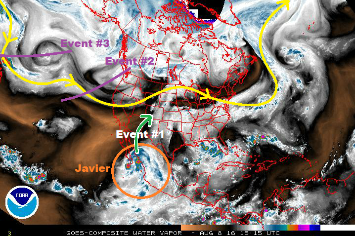
Event #2 will begin to impact the area on Thursday, as dynamics ahead of the upper-level trough provide broad-scale support for showers and thunderstorms. At the same time, a cold front will move southeastward across Colorado, forcing a few showers/thunderstorms as it passes through. Behind it, however, is the bigger story of upslope flow. This will provide an uptick in low-level moisture, as well as enhance wind shear, leading to the return of organized convection, with a few storms on the strong/severe side. Friday and Saturday, as the upper-level trough passes to the east, expect the air mass to gradually dry out from west to east, with fewer storms each day. After Event #2, an upper-level ridge will build in ahead of Event #3, leading to a drier period overall. Aside from a few weaker thunderstorms over the higher terrain that can make the most of residual moisture and orographic effects, much of the state will remain mostly sunny and dry, especially over far eastern Colorado.
Event #3 will be associated with the upper-level disturbance/trough marked on the water vapor image above. Currently, the timing for its impacts to reach Colorado will be Sunday, August 21st. No flood threat is apparent at this time as there is too much uncertainty regarding its eventual path and the amount of moisture that can return ahead of it. For that reason, no event discussion will be issued below. Stay tuned to Thursday’s FTO for more on this time frame.
Event #1: Wednesday (08-10-2016)
Elevated Flood Threat due to Subtropical Moisture Surge
Before the next upper-level trough can move into the region, a subtropical moisture surge from the southwest will bring an increase in showers/thunderstorms. Much of this increase will be felt over the mountains, but a few storms will work across the lower elevations of eastern Colorado, as well. Antecedent conditions from previous rainfall is a concern across southwestern Colorado, especially in the steep terrain.

Event #2: Thursday (08-11-2016) through Saturday (08-13-2016)
Elevated Flood Threat as Upper-Level Trough Slides Through
The first impacts from Event #2 will be felt on Thursday, as broad-scale support fills in overhead with the approach of the upper-level trough. Meanwhile, at the surface, a cold front will move across the state, forcing a few showers/thunderstorms as it passes through. Behind it, upslope flow will provide an uptick in low-level moisture, fueling more efficient rainfall. Additionally, enhanced wind shear due to the change in surface wind direction will result in more organized convection, with a few storms becoming strong/severe. As the upper-level trough continues to pass to the east on Friday and Saturday, each day will result in fewer storms as the air mass gradually dries out from west to east.